GIS Methodologies for Developing Conservation Strategies Part 10 pps
Bạn đang xem bản rút gọn của tài liệu. Xem và tải ngay bản đầy đủ của tài liệu tại đây (563.72 KB, 26 trang )
Appendix 1 221
Northstar Technologies 8500 Beacon Receiver Board NA $675 (24)
8700 GPS Sensor 12 $995 (24)
8800 Beacon Receiver NA $1,095 (24)
8900 DGPS Receiver 12 $2,780 (24)
941 Series GPS Navigator 12 $2,295–$3,295 (24)
951 Series Electronic Chart 12 $2,895–$3,795 (24)
NovAtel Communications GISMO 12 $9,950–$13,450 (24)
GPSCard OEM Performance 12 $3,495–$5,990 (12)
Series
GPSCard OEM Standard 12 $2,495–$3,990 (12)
Series
GPSCard PC Performance 12 $3,495–$5,990 (12)
Series
GPSCard PC Standard 12 $2,495–$3,990 (12)
Series
Hydrographic Surveyor 12 $6,995–$7,995 (12)
RT-20 12 $9,995 (12)
Omnistar 6300A Plus 8 $6,200 (12)
Premier GPS Inc. Newton Surveyor Jr. 8 $4,499 (12)
Smartbase-12 all in view $9,398 (12)
Smartbase-8 8 $7,998 (12)
Rockwell Zodiac/Jupiter 12 $70 (18)
Semiconductor Systems
Sercel NR 108 10 $9,980 (12)
Sokkia Corporation GSR 1000 (North and South 12 $9,000 (12)
America only)
GSR 1100 (North and South 12 $6,900 (12)
America only)
S100 6 $1,995 (12)
S200 12 NA (12)
Starlink Inc. DNAV-212 12 $5,000 (12)
Trimble Navigation GeoExplorer 8 $2,995 (3)
Mobile GPS Locator 8 $495 (12)
Mobile GPS PC Card 110 8 $595 (12)
Mobile GPS PC Card 115 8 $1,295 (12)
Site Surveyor SS 9 inquire (3)
(12 optional)
SVeeSix 104 8 OEM pricing
(12)
II Morrow Inc. Apollo Gis 940 6 $2,995 (12)
Max. no. List Price
satellites in U.S.$
Manufacturer Model tracked (war./mo.)
This page intentionally left blank
Appendix 2
Ordering Information for Map of the Habitats
of Costa Rica
A poster sized (26 x 30 inches) and more detailed version of the map shown in
color plate 1 is available. The map includes information on obtaining data sets
used in the USAID project that are currently available on the Internet. To place a
map order contact:
Kathy Skinner
Strom Thurmond Institute
PO Box 345130
Clemson University
Clemson, SC 29634–5130
telephone (864) 656–4700; fax (864) 656–4780
Shipping and handling costs for the map tube mailing are $5.00 for U.S. requests
and $8.00 for international requests (prices subject to change). Make checks
payable to Clemson University.
Appendix 3
Description of the Twenty-one Wildlife Species
Information on the bird species is from Perrins (1990) and Stiles and Skutch
(1989). Information on mammals is from Nowak (1991) and Timm et al. (1989).
Information on reptiles is from Burton and Burton (1975) and Ross and Magnus-
son (1989). Data on the status of species is from the World Conservation Union
(1988) and MINAREM/MNCR/INBIO (1992).
Mammal Species
Primates
Alouatta palliata (mantled howler monkey, Mono congo). The howler monkey is
among the largest of the New World primates, with a head and body length of
56 to 92 centimeters and a tail length of 59 to 92 centimeters. It has a preference
for primary forest but occurs in disturbed habitats as well and can be found
between southern Mexico and Ecuador. It is the most abundant nonhuman
primate in Costa Rica. The howler monkey is not listed by the IUCN.
Ateles geoffroyi (black-handed spider monkey, Mono colorado). The spider mon-
key is an agile primate measuring 38 to 64 centimeters in head and body length
and 51 to 89 centimeters in tail length. The black-handed spider monkey inhabits
rain and montane forests between northeastern and western Mexico and western
Panama. The spider monkey is listed as vulnerable by the IUCN.
226 Appendix 3
Cebus capucinus (white-faced capuchin, Mono carablanca). The white-faced capu-
chin inhabits a variety of types of forest types and can be seen in mangroves and
sparsely forested areas. The white-faced capuchin is found from Belize and
Honduras to western Colombia and Ecuador. It measures 31 to 57 centimeters in
head and body length and 30 to 56 centimeters in tail length. The white-faced
capuchin is not listed by the IUCN.
Saimiri oerstedii (Central American squirrel monkey, Mono ardilla). This squirrel
monkey is only found in a small area on the Pacific coast of Costa Rica and
Panama. It utilizes primary and secondary forests as well as cultivated areas. The
squirrel monkey has a head and body length of 26 to 36 centimeters and a tail
length of 35 to 43 centimeters. The squirrel monkey is listed as endangered
globally by the IUCN and vulnerable in Costa Rica.
Cats
Herpailurus yagouaroundi (jaguarundi, Leon Bren
˜
ero). The jaguarundi is a small
cat that inhabits lowland forests and thickets between southern Texas and north-
ern Argentina. It has two color phases, gray to black and red. The jaguarundi has
a head and body length of 55 to 77 centimeters, a tail length of 33 to 60 centime-
ters, and weighs 4.5 to 9 kilograms. The jaguarundi is listed as indeterminate by
the IUCN.
Leopardus pardalis (ocelot, Manigordo). The ocelot is also a small cat. It can be
found in humid tropical forests and fairly dry scrub between Texas and northern
Argentina. The ocelot has a background color of yellow to gray with dark streaks
and spots. It has a head and body length of 55 to 100 centimeters, a tail length of
30 to 45 centimeters, and weighs 11.3 to 15.8 kilograms. The ocelot is listed as
vulnerable by the IUCN and endangered in Costa Rica.
Leopardus wiedii (margay, Cauce
´
l). The margay resembles the ocelot but is smaller
and has a longer tail. It is mainly a forest dweller and can be found between
northern Mexico and northern Argentina. The margay is yellowish brown with
rows of dark brown spots. It has a head and body length of 46 to 79 centimeters
and a tail length of 33 to 51 centimeters. The margay is listed as vulnerable by
the IUCN.
Panthera onca (jaguar, Jaguar). The jaguar has been exterminated in the United
States, in much of Central America, and in most of Mexico, Argentina, and
eastern Brazil. It is a spotted cat that is found in forests and savannas. The jaguar
has a head and body length of 112 to 185 centimeters, a tail length of 45 to 75
centimeters, and weighs 36 to 158 kilograms. The jaguar is listed as vulnerable
by the IUCN and endangered in Costa Rica.
Appendix 3 227
Puma concolor (mountain lion or cougar, Puma). The mountain lion is also known
as cougar, panther, and puma. It has the greatest natural distribution of any
mammal in the western hemisphere other than man. It can be found at elevations
from sea level to 4,500 meters and in grasslands, swamps, and all types of forest.
The mountain lion can be found wherever cover and prey are available. It has
two color phases, cinnamon and gray. The male has a head and body length of
105 to 196 centimeters, a tail length of 66 to 78 centimeters, and weighs 67 to 103
kilograms. The cougar is listed as vulnerable in Costa Rica.
Other Mammals
Agouti paca (paca, Tepezcuintle). The paca is a nocturnal rodent that inhabits
forested areas near water. It is found between central Mexico and Paraguay. The
paca is brown to black with four rows of white spots on each side, and it has a
white underpart. It has a head and body length of 60 to 80 centimeters, a tail
length of 2 to 3 centimeters, and weighs 6.3 to 12 kilograms. The paca is not
listed by IUCN.
Myrmecophaga tridactyla (giant anteater, Oso caballo). The giant anteater is distin-
guished by its long narrow snout and its bushy tail. It is found in humid forests,
swamps, grasslands, and savannas between Belize and northern Argentina. The
giant anteater is gray with a black diagonal stripe with white borders. It has a
head and body length of 100 to 120 centimeters, a tail length of 65 to 90 centime-
ters, and weighs 18 to 39 kilograms. The giant anteater is listed as vulnerable by
the IUCN and endangered in Costa Rica, and might already be extinct in the
country.
Tapirus bairdii (Baird’s tapir, Danta). The tapir is a shy, solitary animal. It is dark
or reddish brown and has thick skin and bristly hair. The tapir inhabits woody
or grassy habitat where water is available. It can be found between southern
Mexico and Colombia and Ecuador. It has a head and body length of 180 to 250
centimeters, a tail length of 5 to 13 centimeters, and weighs 180 to 320 kilograms.
The tapir is listed as vulnerable by the IUCN.
Tayassu pecari (white-lipped peccary, Chancho de Monte) and Pecari tajacu (col-
lared peccary, Saı
´
no). The peccary is similar to the wild hog and grubs for food
with its snout. The species are found between southern Mexico and northeastern
Argentina. Peccaries utilize a variety of habitat from forest to desert scrub.
They are mostly herbivorous but will also consume snakes or small vertebrates.
Peccaries have a head and body length of 75 to 100 centimeters, a tail length of
1.5 to 5.5 centimeters, and weigh 14 to 30 kilograms. The white-lipped peccary is
larger than the collared peccary. The white-lipped peccary is dark brown to black
228 Appendix 3
and is white on the sides of its jaws. The collared peccary is dark gray with a
white collar on its neck. The white-lipped peccary is listed as vulnerable in Costa
Rica; neither species is listed by IUCN.
Bird Species
Ara ambigua (great green macaw, Guacamayo verde maior). The green macaw
inhabits humid lowland forests between eastern Honduras and northwest Co-
lombia and western Ecuador. It grows to 79 centimeters in height. In Costa Rica
it specializes on the fruit of Dipteryx panamensis and is largely restricted to the
Caribbean lowlands. The great green macaw is not listed by the IUCN. In Costa
Rica it is threatened.
Ara macao (scarlet macaw, Guacamayo rojo). The scarlet macaw is a multicolored
parrot which inhabits lowland forests up to elevations of 400 meters. The scarlet
macaw is an adaptable bird which thrives in a variety of habitats. Its populations
appear to be limited by the availability of trees having suitable nesting cavities.
Scarlet macaws are generally seen in pairs, grow to 85 centimeters, and can be
found from southern Mexico to northern Bolivia and central Brazil. Currently
restricted in Costa Rica to isolated areas and reserves on the Pacific slope. The
scarlet macaw is not listed by the IUCN, but is considered vulnerable in Costa
Rica.
Crax rubra (great curassow, Pavo
´
n grande). The great curassow is one of the first
birds to disappear after the forest is exploited by humans. It is similar in body
shape to a pheasant and is approximately 97 centimeters in length. The great
curassow inhabits undisturbed mature forest and scrub between Mexico and
western Ecuador and western Colombia. In Costa Rica it persists in some of the
larger national parks. The great curassow is not listed by the IUCN; it is vulnera-
ble in Costa Rica.
Harpia harpyja (harpy eagle, Aguila arpı
´
a). The harpy eagle is one of the most
powerful birds of prey in the world, capable of taking large monkeys, sloths, and
porcupines. It is 91 to 110 centimeters in height. The harpy eagle can be found
from southern Mexico to northern Argentina, typically in lowland tropical forest.
Nearly extinct in Costa Rica, with a few perhaps surviving in the Osa Peninsula,
the Talamanca Mountains, and near the Nicaraguan border. The harpy eagle is
listed by the IUCN as rare globally. It is considered threatened in Costa Rica.
Pharomachrus mocinno (resplendent quetzal, quetzal). The quetzal lives in humid
cloud forests, usually between elevations of 1,200 and 3,000 meters. It has a size
Appendix 3 229
of 35 to 38 centimeters and can be found between southern Mexico and western
Panama. It can be found in deforested areas if sufficient feeding and nesting trees
remain. The resplendent quetzal is listed by the IUCN as vulnerable.
Reptile Species
Caiman crocodilus (common caiman, Guajipal). The common caiman is indeed one
of the most common species of crocodilians and occurs in a variety of fresh water
habitats. Caimans feed primarily on insects, other invertebrates, crabs, and fish.
The caiman can be found from southern Mexico through the Amazon to northern
Argentina. The common caiman is listed by IUCN as threatened.
Crocodylus acutus (American crocodile, Cocodrilo). The American crocodile is
among the largest of reptiles and can attain lengths of greater than six meters. It
can be found in rivers and shallow waters such as swamps and marshes as well
as in estuarine and coastal areas. The crocodile can be found in Florida and the
Caribbean Basin and from southern Mexico to northern South America. It occurs
on both coasts of Costa Rica. The American crocodile is listed by IUCN as
endangered.
References
Burton, M. and R. Burton. 1975. Encyclopedia of reptiles, amphibians, and other cold-blooded
animals. New York: Crescent.
MINAREM/MNCR/INBIO. 1992. Estudio Nacional de Biodiversidad. San Jose
´
, C.R.: Minis-
terio de Recursos Naturales, Energı
´
a, y Minas, Museo Nacional de Costa Rica, Insti-
tuto Nacional de Biodiversidad.
Nowak, R. M. 1991. Walker’s mammals of the world. 5th ed. Baltimore: Johns Hopkins
University Press.
Perrins, C. M. 1990. The illustrated encyclopedia of birds: The definitive reference to birds of the
world. Englewood Cliffs, N.J.: Prentice-Hall.
Ross, C. A. and W. E. Magnusson. 1989. Living crocodilians. In C. A. Ross, ed., Crocodiles
and alligators, 58–73. New York: Facts on File.
Stiles, F. G. and A. F. Skutch. 1989. A guide to the birds of Costa Rica. Ithaca, N.Y.: Comstock.
Timm, R. M., D. E. Wilson, B. L. Clauson, R. K. LaVal, C. S. Vaughan. 1989. Mammals of La
Selva–Braulio Carrillo Complex, Costa Rica. North American Fauna no. 75. Washington,
D.C.: U.S. Fish and Wildlife Service, Department of the Interior.
World Conservation Union (IUCN). 1988. 1988 IUCN red list of threatened animals. Gland,
Switzerland: International Union for Conservation of Nature and Natural Resources.
This page intentionally left blank
Appendix 4
Summary of Wildlife Survey
Category Occupation Number
Researcher Parataxonomy 7
Wildlife 1
Conservation 13
Biology 5
Archaeology 1
Subtotal 27
Security Park Guard 59
Wildlife Inspector 11
Rural Guard 27
Police 3
Subtotal 100
Education Environmental Education 3
Teacher 2
Student 2
Retired 3
Subtotal 10
Domestic Housewives 5
Subtotal 5
232 Appendix 4
Service Industry Forest Fire Fighters 2
Municipal Government 2
Office Worker 2
Construction 7
Mason 1
Forestry Technician 2
Tanner 1
Maintenance 2
Waiter 2
Administrator 8
Miscellaneous 6
Drover 6
Photographer 2
Tourism Worker 5
Tour Guide 2
Subtotal 50
Fishing Fisherman 11
Subtotal 11
Agriculture Farmers 172
Ranchers 6
Day Laborer 8
Migrant Worker 6
Field Boss 5
Farm Owner 3
Equipment Operator 3
Subtotal 203
TOTAL 406
Category Occupation Number
Breakdown by Time of Residence
Range Number of People
0 to 5 years 55
6 to 10 years 46
11 to 15 years 28
16 to 25 years 64
More than 20 years 213
TOTAL 406
Appendix 5
List of Participants at UNA/USAID
GIS Workshop (March 6–8, 1995)
Institution Name
Acueductos y Alcantarillados Gerardo Ramirez Villegas
Roy Valverde Villalobos Ovares
Area de Conservacio
´
n La Amistad Nelson Mora Mora
Adrian Arias N.
Fernando Quiro
´
sB.
Boris Gamboa Valladares
Area de Conservacio
´
n Tortuguero Carlos Manuel Calvo Gutie
´
rrez
Eduardo Rodrı
´
guez Herrera
Area de Conservacio
´
n Pacifico Central Miguel Madrigal
Area de Conservacio
´
n Volcanica Rodolfo Tenorio Jime
´
nez
Central
CATIE, Turrialba Gre
´
goire Leclerc
Centro Cientı
´
fico Tropical Patricia Barrantes Padilla
Carlos Rodrı
´
guez Rodrı
´
guez
234 Appendix 5
Clemson University Thomas E. Lacher Jr.
Basil G. Savitsky
Comisio
´
n de la Sociedad Civil, Victor Villalobos Rodrı
´
guez
MIRENEM
Comisio
´
n de Ordenamiento Territorial, Jorge Cotera Mira
SINADES (Sistema Nacional de Oscar Luke Sa
´
nchez
Desarrollo Sostenible)
Consultora Cuatro Estaban Dorries B.
Direccio
´
n General Forestal Vera Violeta Montero Castro
DRIP (Desarrollo Rural Integral Tiny Luiten
Peninsula), Peninsula de Nicoya
Fundacio
´
n ACCESO Maria Sa
´
enz Go
´
mez
FUNDECOR Johnny Rodriguez Chaco
´
n
INBIO Marco Castro Campos
Vero
´
nica Sancho Solls
Instituto Costarricense de Electricidad Johnny Molina Garcia
Javier Saborio Bejarano
Instituto Costarricense de Turismo Francisco Arago
´
n Solo
´
rzano
Instituto Metereologico Nacional Jorge Arturo Barrantes
Instituto Desarrollo Agrario Jorge Campos Salas
Instituto Geogra
´
fico Nacional Fernando Quiro
´
s
Christian Asch Quiro
´
s
Carlos Elizondo Solls
Ministerio de Agricultura y Ganaderı
´
a Oscar Go
´
mez
Carlos Leo
´
n
Institution Name
Appendix 5 235
Institution Name
Ministerio de Ciencia y Tecnologia Teresita Quesada Granados
MIRENEM Walter Quiro
´
s Gonza
´
lez
OET Jenny Jua
´
rez Porras
Parques Nacionales Jorge Cerdas Aguilar
SENARA Sandra Arradondo Li
Germa
´
n Matamoros Blanco
SISVAH Melvin Molina Herra
UCR, Escuela de Geografı
´
a Francisco Solano Mata
UCR, CIGEFI Javier Soley Alfaro
UNA-ECG Timothy Robinson
UNA-TELESIG Jorge Fallas Gamboa
Wilfredo Segura Lo
´
pez
Carlos Madriz Vargas
Henry Chaves Klel
This page intentionally left blank
Contributors
Jeffery S. Allen is the Research Coordinator at the Strom Thurmond Institute of
Government and Public Affairs at Clemson University, Clemson, South Carolina.
Joseph A. Bishop is a Ph.D. candidate in ecology at Pennsylvania State Univer-
sity, State College, Pennsylvania.
G. Wesley Burnett is a professor at Clemson University, Clemson, South Caro-
lina, in the Department of History/Geography and the Department of Parks,
Recreation, and Tourism Management.
Margaret H. Carr is an assistant professor in the Department of Landscape
Architecture at the University of Florida, Gainesville.
Jorge Fallas is a professor in the Regional Wildlife Management Program for
Mesoamerica and the Caribbean (PRMVS) at Universidad Nacional, Heredia,
Costa Rica.
Thomas E. Lacher Jr. is Professor and Caesar Kleberg Chair in Wildlife Ecology
and Fisheries Sciences at Texas A&M University, College Station, Texas.
J. David Lambert is a Research Manager at the University of Florida Geoplan
Center and is a Ph.D. candidate in Urban and Regional Planning at the University
of Florida, Gainesville.
Gre
´
goire Leclerc has a Master of Science degree in Radiobiology and a Ph.D.
in Physics from Sherbrooke University, Canada. He completed a postdoctoral
fellowship with the Centre d’Applications et de Recherches en Te
´
le
´
de
´
tection
(CARTEL) in the Centro Agrono
´
mico Tropical de Investigacio
´
n y Ensen
˜
anza
(CATIE) in Costa Rica. He is now Senior Research Fellow working in the GIS
facility of the International Center for Tropical Agriculture (CIAT) in Cali, Co-
lombia.
Wilfredo Segura Lo
´
pez received his Master of Science degree at the Regional
Wildlife Management Program for Mesoamerica and the Caribbean (PRMVS) at
Universidad Nacional, Heredia, Costa Rica.
Michael McCoy is a professor in the Regional Wildlife Management Program for
Mesoamerica and the Caribbean (PRMVS) at Universidad Nacional, Heredia,
Costa Rica.
Jennifer N. Morgan received a Bachelor of Science degree in Aquaculture, Fisher-
ies, and Wildlife at Clemson University, Clemson, South Carolina, and is cur-
rently working toward a Master of Science degree in Forest Resources at the
University of Georgia, Athens.
Johnny Rodriguez Chaco
´
n has a Bachelor of Engineering degree in Tropical
Forestry from Universidad Nacional, Heredia, Costa Rica. He has been in charge
of the GIS facility of the Fundacio
´
n para el Desarrollo de la Cordillera Volcanica
Central (FUNDECOR) since 1993.
G. Arturo Sa
´
nchez-Azofeifa is an associate research professor at the Research
Center on Sustainable Development (CIEDES) at the University of Costa Rica,
San Jose
´
.
Basil G. Savitsky is an assistant professor in the Graduate School of Geography
at Clark University in Worcester, Massachusetts, and Coordinator of the Master’s
Program in GIS and International Development.
Christopher Vaughan is a professor in the Regional Wildlife Management Pro-
gram for Mesoamerica and the Caribbean (PRMVS) at Universidad Nacional,
Heredia, Costa Rica.
Elizabeth A. Wentz is an assistant professor in geography at Arizona State
University in Tempe.
238 Contributors
Index
accuracy assessment, 72, 171
aerial photography, 29, 48, 51, 53, 57, 100,
161
Africa, 46, 52, 53, 58, 59, 60, 152, 157, 181,
211, 212, 213, 218
Agenda 21, 154, 217
agroforestry, 84, 184
Amazon, 39, 52, 53, 58, 60, 153, 156, 202,
205, 229
anthropological reserve, 141, 142, 180, 181,
185, 186
ARC/INFO (software), 35, 66, 90, 91, 92,
95, 140, 159, 161, 165, 176, 179, 200
Arenal, 16, 130
automation. 31
AVHRR. See satellite sensors
biological corridors, 135, 138, 145
biological diversity, 12, 15, 60, 95, 142, 151,
152, 153, 155, 156, 157, 169, 178, 214, 218;
biodiversity, 10–13, 15, 22, 24–25, 42, 87,
95, 108, 138–39, 142–43, 146–47, 152–54,
156–58, 163–64, 169, 196–97, 203–205,
208–209, 217–18; biodiversity assess-
ment, 154, 204; biodiversity survey, 83
biological research station, 83
brain drain, 37, 201
Brazil, 10, 12, 39, 40, 55, 60, 65, 202, 205,
208, 226, 228
buffer areas, 108, 181, 192
buffer zone, 16, 108, 115, 116, 119, 123, 125,
139, 188, 205, 208
butterfly distributions, 163
CAMS. See satellite sensors
canopy map, 67, 68
Caribbean Conservation Corporation, 138
cartography, 29, 30, 31, 40, 61, 69, 106
catchment boundaries, 96, 101
CATIE (Centro Agrono
´
mico Tropical de In-
vestigacio
´
n y Ensenanza), 19, 109, 233
CD-ROM (hardware), 30, 38, 146, 152
Central Pacific, 16
change detection, 23, 36, 52–54
Cherokee Trail, 66
classification: supervised, 50, 51, 54, 103,
161; unsupervised, 50, 51, 54, 159
CI-SIG (GIS package), 200
cloud cover, 36–37, 56–57
coffee, 13, 17, 98,99
collaboration, 9, 54, 58, 138, 202–205, 217;
multinational, 138, 140, 146, 203, 204;
transboundary, 203; conflict resolution,
46, 216
conservation biology, 4, 12, 19, 23–25, 156–
57, 198, 213
conservation data center, 22, 163
conservation goals, 213, 216
Conservation International, 24, 136, 153,
156, 200, 202, 208, 209
240 Index
conservation planning, 23, 138, 144, 146,
154, 206, 212
conservation priorities, 152–53, 202, 205,
207, 209, 214
Corcovado National Park, 21
Cordillera Volcanica, 16, 108
critical areas, 108–11, 121, 123, 125
cropland, 5, 7
cross-disciplinary research, 86
data: ancillary, 53–54, 161; attribute, 44,
66–67, 70, 91; data exchange, 31; data
gap, 184–85, 189–90, 192–93; data integra-
tion, 38, 86, 92–93; data sharing, 38, 94;
data sources, 29–30, 36–7, 44, 48, 53, 57,
140, 159, 161; digital, 11, 21, 30–31, 36, 50,
86, 89, 130, 140; point, 91, 167, 186; raster,
44, 70; tabular, 89–90; vector, 44, 130, 142
decision cube, 151, 179–81, 191, 216
decision making, 9, 11, 45, 47, 135, 154,
179, 217
deforestation, 14, 20, 24, 32, 39, 52–53, 58–
60, 87, 95–96, 99, 102, 105–106, 110, 123–
25, 176, 185, 198
DEM. See digital elevation model(s)
design study, 84–88
developing countries, 6–7, 9, 29, 32–33,
35–37, 45–46, 58, 153, 199–202, 204–205,
210–11, 216–17
development: development plan, 206–207,
214, 216; economic development, 24, 46,
83, 152, 185, 198, 208, 214, 216; interna-
tional, 9, 46, 126, 207; sustainable, 7–8,
16, 23–24, 108, 152, 199, 206–208, 217–18
DGF (Direction General Forestal), 108, 115
Digital Chart of the World, 30, 38, 140, 146
digital elevation model(s), 96–97, 99–105
drainage network, 96–97, 100–102, 105–
106
Earth Observation Satellite Company (EO-
SAT), 200
Earth Observing System (EOS), 30
ecological triage, 205
ecosystem, 4, 10, 15, 24–25, 38, 52, 60, 151,
155, 156, 188, 203–206, 208, 213–14, 216
ecotourism, 13, 23, 108, 139
Endangered Species Act, 152
endemism, 155
Environmental Systems Research Institute
(ESRI), 30, 38, 95, 140, 142, 146, 200
error: biological, 170, 173–74; commission,
172; geographic, 170, 189; omission, 172
EOS. See Earth Observing System
EOSAT. See Earth Observation Satellite
Company
EROS (Earth Resources Observation Sys-
tem) Data Center, 100
ESRI. See Environmental Systems Re-
search Institute
field biology, 17–19, 24
field studies, 19, 23, 92
flow accumulation, 101
forested areas, 7, 65, 108, 141, 169, 189,
226–27, 229
fragmentation, 138, 156, 176
FUNDECOR: Fundacio
´
n para el Desar-
rollo de la Cordillera Volcanica Central
(Foundation for the Development of the
Central Cordillera), 108–10, 115–16, 118,
125–26, 234
game ranching, 128
geometry, 3, 4, 11
global change, 53, 200, 203, 207
Global Positioning System (GPS), 8, 29, 32,
38–40, 44, 57, 61–79, 130, 137, 151, 219–
21; differential correction, 64–65, 67, 69,
71–72, 78; elevation, 20, 31, 44, 53–54, 64,
74, 77, 92, 96, 99, 105–106, 158, 162, 173,
227–28; multi-channel, 67; Selective
Availability, 63
ground control point, 67–68
ground truth, 51, 72
Habitat Conservation Decision Cube, 151,
179–81, 191
habitat map, 54, 154, 158–59, 161, 166–67,
171–72, 210–11
habitat mapping, 48, 51, 52, 54–55, 57, 127,
135–36, 154, 210
habitat suitability index, 131
herpetology, 84, 169
IDA (Instituto de Desarrollo Agrario). See
Institute of Agrarian Reform
IDRISI (software), 35, 47, 110–11, 113–14,
117, 126, 130–31, 136, 200
IGN (Instituto Geogra
´
fico Nacional de
Costa Rica). See National Geographic In-
stitute of Costa Rica
Index 241
INBIO: Instituto Nacional de Biodiversi-
dad (National Institute of Biodiversity),
22, 205, 208, 225, 229, 234
indigenous population, 141, 142
information system, 4, 33–36, 38, 40–41,
47, 58–59, 78, 95, 106, 137, 156, 198
infrared, 48, 50–52, 89
Institute of Agrarian Reform (IDA), 110–
11, 118–19, 134
Internet, 30, 36, 71, 87, 223
island biogeography, 4, 12, 146
IUCN. See World Conservation Union
La Amistad, 16, 21, 185, 189–90, 192–93,
208, 233
land acquisition, 139, 151, 155, 181, 187–
88, 190
land cover, 30–31, 50–51, 53, 58, 60, 97, 115,
153, 155, 159, 166, 171, 177, 187, 210–11,
214
Landsat, 49–51, 53, 55–60, 67, 101, 123, 130,
152–53, 159, 200, 210
landscape, 3–5, 10–11, 15, 73, 99, 127,
138, 146–47, 156, 158, 161–64, 173, 184–
85, 188, 191, 195–97, 203, 205, 206,
208
land use, 3–7, 10–11, 22, 50–51, 60, 78, 87,
96–97, 99, 102–106, 123–24, 140, 155, 159,
169, 171, 177, 187, 193, 213–14, 216
lifezone, 15, 24, 53, 128, 130, 136, 141–42,
146, 158, 166, 169, 171, 173, 218
load capacity model, 135
mammalogy, 25
management: ecosystem, 213–14; inte-
grated, 203, 205; natural resource, 14–16,
38–40, 42, 59, 61; wildland, 15–16; wild-
life, 9, 12, 19, 23, 32, 38, 39, 72, 137, 152,
155, 165, 181, 185, 191, 208
metapopulation dynamics, 4, 11
MNCR (Museo Nacional de Costa Rica).
See National Museum of Costa Rica
monoculture, 17
MSS. See satellite sensors
multicriteria analysis, 109
multitemporal analysis, 52, 56
museums, 3, 19, 23, 39, 84, 204, 208
National Biological Service, 152
National Geographic Institute of Costa
Rica (IGN), 87, 89, 130, 159, 169, 171
National Museum of Costa Rica (MNCR),
23, 225, 229
natural history, 4, 18–19, 24, 39, 204, 208
Nature Conservancy, the, 22
navigation, 61–65, 67, 72, 78–79, 130, 137,
140, 219–21
Organization for Tropical Studies (OTS),
19, 73, 84, 94–95
ornithology, 84
Osa, 16, 169, 228
pair-wise analysis, 109–11
parks: boundary adequacy, 213; design of,
3–4; park boundaries, 87, 184, 213; pri-
vate reserves, 179, 186, 205; protected
area’s boundaries, 213
Paseo Pantera, 138–39, 141, 146, 179, 202
pasture, 5, 7, 51, 54, 84, 99, 104, 108, 131,
132, 159, 161, 166, 169, 172–73, 176, 187,
189, 192
Pathfinder, 53, 58, 66, 67, 70, 72–73, 79, 137
personal computer, 30, 35
policy, 9–11, 17, 23–24, 31, 41–42, 84, 87,
151–52, 156–57, 181, 184–85, 189, 191,
198, 200, 202, 208
population density, 110–11, 113, 116, 141–
43
positional accuracy, 64, 171
primates, 91, 162, 176, 181, 205, 225
protected areas, 3–4, 14–15, 24, 108, 139,
141, 143, 151–56, 158, 161–62, 169, 179–
80, 184, 185, 187, 190–91, 193, 196–97, 213
radio telemetry, 87
reforestation, 108
Regional Conservation Areas, 16. See also
individual names of RCAs
resolution: radiometric, 48–50; spatial, 44,
48–49, 51, 54–57, 210, 211; spectral, 48–49,
51; temporal, 48, 50
restoration, 15–16, 24, 139, 183–84, 189,
192, 198, 208, 216
satellite sensors, 48; AVHRR (Advanced
Very High Resolution Radiometer), 49–
53, 55–59, 211; CAMS (Calibrated Air-
borne Multispectral Scanner), 89; MSS
(Landsat Multispectral Scanner), 49–53,
55–56, 58, 200, 210, 211; radar, 37, 48, 54,
57–58, 60, 89; TIMS (Thermal Infrared
242 Index
satellite sensors (Continued)
Multispectral Scanner), 89; TM (Landsat
Thematic Mapper), 49–57, 60, 67–68, 101,
103, 123, 152, 159, 161, 171, 200, 210, 211
scanners, 35, 44, 48, 87, 89, 211
scientific imperialism, 204, 217
shape and function, 11
species: edge species, 174; endangered spe-
cies, 135, 152, 164, 184, 202, 205; general-
ist, 164, 174, 176, 184, 189; indicator spe-
cies, 162–64, 184, 195–97, 211–12; reintro-
duction, 128, 135, 184; species range
maps, 163
staff, 18, 33–35, 37–38, 51, 58, 72, 74, 84, 86,
93, 161, 165, 171, 179, 201–202, 204, 210
stream order, 102
Structured Query Language (SQL), 91
sustainable development, 7–8, 16, 23–24,
108, 152, 199, 206–208, 217–18
systematics, 11, 204
technical support, 35, 71, 87
technology, 8–11, 21, 23, 29, 31–33, 35–36,
38–39, 40, 46–47, 59–61, 69, 73, 78, 79, 93–
94, 125, 128, 141, 144, 151, 203–205, 207,
211, 217, 219
technology transfer, 9, 31–33, 39, 46, 69,
205, 217
Tempisque, 16, 128, 130
time series, 102
TIMS. See satellite sensors
TM. See satellite sensors
Tortuguero, 16, 169, 189, 192–93, 233
training, 12, 24, 35, 37–38, 46–47, 51, 54, 61,
63, 65, 69–70, 72–73, 78, 84, 86, 92–94,
200, 201, 217
transect, 66–7
tropics, 10–11, 23–24, 36–37, 48, 52, 54–57,
60, 74, 76, 84, 87, 97, 153, 177, 203–207,
210–12
United Nations Conference on Environ-
ment and Development (UNCED), 154
United Nations Environment Program
(UNEP), 154, 157, 208–209
United Nations Food and Agricultural Or-
ganization (UNFAO), 58
United States, 5, 8–10, 19, 22, 24, 36, 53, 66,
69–71, 95, 97, 116, 126, 138, 144, 152–54,
156, 163, 170, 181, 200, 202, 205–206, 217,
226
UNIX (workstation), 66, 91
United States Agency for International De-
velopment (USAID), 9, 39, 59, 72, 77, 108,
126, 138–39, 145, 151, 155, 174, 199, 202,
208, 214, 223, 233
U.S. Fish and Wildlife Service, 9, 127, 137,
178, 229
U.S. Government and Affiliate Users
(USGAU), 200
videography, 53, 57
water resources, 96–97, 105–106
watershed, 97, 105–107, 153, 156, 166, 202
waypoint, 68, 78
weighted criteria analysis, 142–43
white-tailed deer, 127, 131–33, 135–37
wildlife corridors, 4
wildlife data collection, 151, 162, 190, 193,
210, 211
workstation, 35, 66, 91
World Bank, 10, 12, 25, 39, 154, 206, 208–
209
World Conservation Union (IUCN), 155–
57, 204, 206–209, 218, 225–29
P
LATE
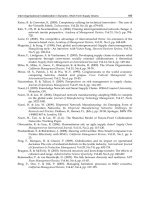
1 Habitat map of Costa Rica
P
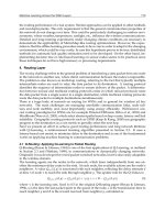
LATE
2 Simplified life zones of Costa Rica based upon methodology of Holdridge
(1971) and maps by Bolan
˜
os and Watson (1993). Potential forest types are based upon
altitude, precipitation, and evapotranspiration potential.
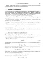
P
LATE
3 Overlay map of all twenty-one species