EARTH SCIENCES - Notable Research and Discoveries Part 5 docx
Bạn đang xem bản rút gọn của tài liệu. Xem và tải ngay bản đầy đủ của tài liệu tại đây (2.1 MB, 24 trang )
earth ScienceS
76
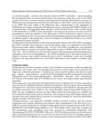
steady, entrenched in the mantle, and the plate will move past it. Plates
move slowly—in a range of one to six inches (2.5–15 cm) a year—but
over millions of years, this movement is signicant. Wilson’s theory
suggested that the chain of Hawaiian islands were formed from this
volcanic activity in a manner that reects the movement of the plate.
As the plate lingers over the hot spot, the volcanic activity builds a sea
-
mount, which gradually rises above the surface to create an island. Aer
some period of time, as the plate moves on, another island in the chain
forms, slightly behind the earlier island. Wilson published his theory in
a report, “A Possible Origin of the Hawaiian Islands,” in a 1963 issue of
the
Canadian Journal of Physics.
Kilauea is a highly active volcano located on the island of Hawaii
(the Big Island). According to Wilson’s theory, the islands farthest from
the current hot spot should be the oldest, since they were formed much
earlier. Kauai, the most northwestern of the major islands in the chain,
has rocks as old as 5 million years. is age contrasts with the Big Is
-
land—the most southeastern island—in which the oldest known rocks
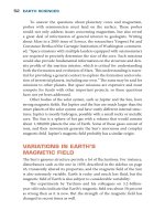
Molokini, a volcanic crater that forms a crescent-shaped island near Maui,
Hawaii (Ron Chapple/Getty Images)
FOS_Earth Science_DC.indd 76 2/8/10 10:58:02 AM
77
are less than 1 million years. e ages of the other islands also agree
with the theory.
Hawaiian volcanoes have been extremely important not only for
volcanologists interested in hot spot theory, but also for legions of tour
-
ists and interested onlookers. Native islanders have been observing
these volcanoes for many generations, and the British explorer Captain
James Cook (1728–79) sighted the Hawaiian Islands in 1778. Written
records of Kilauea began in 1790, showing that the volcano has been
active for most of the past two centuries. In periods of high activity,
such as during eruptions or when lava rises to a visible level, Kilauea
draws a crowd. People such as Mark Twain (1835–1910), who visited
the volcano in 1866, began writing about their experiences, and the
rest of the world became aware of the fascinating spectacle. In 1916 the
U.S. government established Hawaii Volcanoes National Park, which
includes Kilauea on the Big Island. Hawaiian volcanoes continue to be
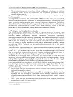
Volcanoes and hot Spots
As the plate moves over the hot spot, a series of volcanoes
form.
FOS_Earth Science_DC.indd 77 2/8/10 10:58:03 AM
earth ScienceS
78
the site of important observations and studies, as described in the fol-
lowing sidebar.
e Hawaiian Islands are the youngest in an extended chain of
volcanic islands and undersea mountains (which do not quite reach
the surface) stretching about 3,700 miles (5,920 km) across the Paci c
Ocean. is chain is known as the Hawaiian-Emperor Seamounts. Ages
of the rocks indicate a progressive increase from northwest to south-
east—the oldest rocks in the northwestern islands and seamounts are
millions of years older than those of the southeast, and the age increases
the farther one moves to the northwest. is “trail” probably marks the
track of the Paci c plate’s motion, but as shown in the following gure,
Hawaiian Volcano Observatory
Scientists who are seeking active volcanoes have found
Kilauea extremely attractive. Perret, the pioneering volca-
nologist, visited Kilauea in 1911, and a year later the Massa-
chusetts Institute of Technology professor Thomas A. Jaggar
(1871–1953) began excavating along the rim of the Kilauea
caldera. Jaggar and his team built a structure with a cel-
lar that housed a seismometer, which he used to monitor
the activity of the region. Money for this kind of geologi-
cal research became easier to obtain after the disaster in
Martinique in 1902 and the devastating earthquake in San
Francisco in 1906, as people started to realize the value of
volcanic and seismic research for society as well as science.
The facility at Kilauea was the beginning of the Hawaiian Vol-
cano Observatory.
Today the Hawaiian Volcano Observatory is a component
of the Volcano Hazards Program of the United States Geo-
logical Survey (USGS). (The history and functions of USGS
are outlined in a sidebar on page 10.) Researchers at the
observatory study Kilauea and Mauna Loa, another volcano
FOS_Earth Science_DC.indd 78 2/8/10 10:58:04 AM
79
there is a sharp bend at about the middle of the chain that is not yet
fully understood, corresponding to about 42 to 48 million years ago.
e plate may have changed direction at this point, or the hot spot may
not be stationary, as discussed below.
Chemical analysis of the lava from the Hawaiian volcanoes yields
clues about their origin. e lithosphere is about 50 miles (80 km)
thick underneath the Hawaiian Islands, so if the magma is coming
from underneath, it might be of a dierent chemical nature than the
lava erupting from shallow mid-ocean ridges. In particular, geolo
-
gists have examined the ratio of isotopes of certain elements such as
helium.
on the Big Island. Mauna Loa is an active volcano, erupting
more than 30 times since 1843, although it has not erupted
since 1984. This massive shield volcano is the largest vol-
cano on Earth—the mountain covers about half of the island
and rises 2.4 miles (4 km) above sea level; its flanks extend
another three miles (five km) beneath the surface of the
ocean.
It was the robust activity of these volcanoes that drew
geologists to the site, and researchers at Hawaiian Volcano
Observatory continue to monitor and track the volcanoes’
behavior, study the history of their eruptions by analyzing
volcanic rocks in the area, and inform the public of the na-
ture and potential hazards of these geological phenomena. In
addition, because the Hawaiian volcanoes are not on a plate
boundary, these volcanoes are important testing grounds
for hot spot theories, although researchers did not know of
this benefit when they initially set up the observatory. Sci-
entific advances come about because of the persistence,
intelligence, and, occasionally, good fortune of scientists.
Researchers who explore the frontiers of knowledge never
know in advance exactly where a project will take them or
how rewarding it will be.
Volcanoes and hot Spots
FOS_Earth Science_DC.indd 79 2/8/10 10:58:04 AM
earth ScienceS
80
Atoms of the same element may have a di erent number of neu-
trons in their nucleus, resulting in di erent isotopes such as helium-3
(which has three particles in the nucleus, two protons and one neu-
tron) and helium-4 (which has two protons and two neutrons in the
FOS_Earth Science_DC.indd 80 2/8/10 10:58:34 AM
81
nucleus). ese isotopes usually have the same chemical properties
but dier in stability—some isotopes are highly radioactive, decay-
ing into other nuclei by emitting certain particles. Helium-3 and
helium-4 are both stable, but helium-4 is a product of a number of
dierent radioactive decays and is far more abundant. e ratio of
helium-3 to helium-4 varies from place to place, and although this
ratio is sometimes dicult to measure—helium is a highly mobile
element—it does get trapped in Earth’s crust. Deeper sources tend to
have more helium-3, which was le over from Earth’s formation as
it coalesced from dust and gas in the galaxy. (Helium and most other
elements are made in stars, which form the materials of Earth and
living creatures.)
e helium-3/helium-4 ratio is distinctly higher in volcanic rocks
from Hawaii than in the volcanic rocks of the mid-ocean ridges. is
dierence suggests, although it does not prove, a dierent origin for the
magma of these two volcanic systems, with the Hawaiian system being
fed by deeper sources. Other isotope ratios from these two systems also
have diering values.
Hawaii is not the only hot spot in the world. Recall that about 5
percent of the world’s active volcanoes are found
at signicant dis
-
tances from plate boundaries. Yellowstone is another example of
hot spot volcanic activity. As in the Hawaiian-Emperor seamount
chain, a track of past volcanism marks a path from southern Oregon
through Idaho and on into Wyoming and Yellowstone, which may
indicate the movement of the North American plate as it glides past
the hot spot.
e existence of volcanoes far from plate boundaries compels geol
-
ogists to accept an alternative explanation for these volcanoes. In some
form or fashion, magma travels through the middle of a plate. But the
properties and origin of this magma have not yet been determined. One
idea involves narrow channels called
plumes reaching as far down as
the deepest part of the mantle, 1,800 miles (2,900 km) beneath Earth’s
surface.
(opposite page) The volcano trail that apparently tracks the movement of
the plate makes a sharp bend about 42 to 48 million years ago.
Volcanoes and hot Spots
FOS_Earth Science_DC.indd 81 2/8/10 10:58:35 AM
earth ScienceS
82
PluME HyPotHESIS
e Princeton geologist W. Jason Morgan published a paper, “Convec-
tion Plumes in the Lower Mantle,” in a 1971 issue of Nature. Morgan
extended Wilson’s hot spot idea by proposing the existence of deep
channels called plumes in which hot materials ow and transfer heat by
the mechanism of convection currents: “In my model there are about
twenty deep mantle plumes bringing heat and relatively primordial ma-
terial up to the asthenosphere and horizontal currents in the astheno-
sphere ow radially away from each of these plumes.” As tectonic plates
move over these magma jets, the molten rock burns a hole through the
plate, forming a hot spot volcano. is gives magma a channel to the
surface without having to seep through cracks between tectonic places.
Morgan believed these plumes play a role in continental dri.
e plume hypothesis is a simple idea. When approaching a problem,
scientists usually consider the simplest solution rst—it is the easiest one
to test, and there is no reason to make the situation any more complicated
than necessary. Geologists would love to be able to pry open the surface
beneath these hot spots and check for any plumes. Finding such
plumes
would be
a powerful piece of evidence supporting the hypothesis.
Searching the crust and mantle by drilling deeply into the surface is
not possible at the moment, so the “eyes” geologists use to study Earth’s
interior are seismic waves. By accumulating enough seismic wave data,
scientists can generate a three-dimensional image of the planet. Seis
-
mic tomography is the name of the technique geologists use to generate
these images. e term tomography comes from Greek words tomos,
meaning “section,” and graphein, “to write”; tomography is the process
of combining sections or slices of data into a three-dimensional image.
A geologist’s use of seismic tomography is similar to a physician
using ultrasound waves to map the interior of a patient’s body. But the
great size of the planet obscures images of the deepest parts. Adequate
pictures of the upper mantle are possible, and geologists have found
narrow channels that may be plumes, including one under Hawaii. But
no one is sure how deep these channels extend.
Recent improvements in seismic tomography have given geologists
the opportunity to probe even deeper. Raaella Montelli, a researcher
at Princeton University in New Jersey, and her colleagues at University
of California, San Diego, University of Colorado,
and National Taiwan
University
use a method known as nite-frequency tomography that
FOS_Earth Science_DC.indd 82 2/8/10 10:58:35 AM
83
combines a larger number of data sets. e method increases resolu-
tion—the ability to discern small or narrow objects in an image. Mon-
telli and her colleagues reported nding plumes that reach the lowest
depths of the mantle in several hot spots, including the Pacic islands
of Tahiti and Easter Island. e picture underneath Hawaii was fuzzier,
but there may also be a similar plume there as well. ese plumes range
in diameter from 60–240 miles (100–400 km). Montelli and her col
-
leagues published their report, “Finite-Frequency Tomography Reveals
a Variety of Plumes in the Mantle,” in a 2004 issue of
Science.
Although the latest methods of seismic tomography provide some
visual evidence for the existence of plumes, images of vast depth can be
hazy and dicult to interpret. ese channels may not be plumes at all.
And tomography has not been able to nd candidate channels in all hot
spot regions.
If the plumes exist, how do they form? Scientists usually consider
evidence for an object more compelling if there is a convincing explana
-
tion of how it can arise. If a plume is an improbable event that is dicult
or even impossible to understand, geologists will be more inclined to
look
for alternatives to explain the channels seen with seismic tomogra
-
phy without having to resort to plumes.
e long trail of islands in the Hawaiian-Emperor seamount chain
indicates that the hot spot currently under Hawaii has been active for
millions of years. is means the plume, if there is one, must be quite
stable. As mentioned earlier, the high temperatures and mobility of
Earth’s interior create convection currents that carry heat from the bot
-
tom upward, with the uid rising as it gets hot and become less dense.
Earth’s mantle is rocky, but the heat is intense, especially in the lower
depths, so the rocks are hot enough to undergo some degree of melt-
ing. is partial melting contributes to the shiing and gliding of the
tectonic plates and may also provide an environment in which narrow
jets—plumes—can survive for long periods of time.
Although the dynamics of Earth’s interior may create opportunities
for mantle plumes to form, how these narrow jets of magma actually arise
is not at all obvious. But Anne Davaille, a researcher at the Institut de
Physique du Globe de Paris (Institute of Geophysics of Paris) in France,
along with other scientists, has experimented with miscible viscous
u
-
ids—substances that can ow and mix together. When dierent uids
are placed in contact, such as pouring milk in a cup of water, the uids
Volcanoes and hot Spots
FOS_Earth Science_DC.indd 83 2/8/10 10:58:35 AM
earth ScienceS
84
will o en mix and form a single combined substance rather than form-
ing separate layers. But mixing does not always occur—oil and water, for
example, do not mix—and the degree of blending depends on the proper-
ties of the uids, such as thickness or resistance to owing (viscosity).
Davaille has tested the behavior of uids in a two-layer system, in
which she adjusted the viscosity of the uids by dissolving some amount
of salt or cellulose in them. She heated the bottom layer and cooled the
top layer, setting up a temperature gradient—a di erence—between the
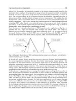
Plumes and Superplumes
A stable plume is a narrow jet of fl owing magma, but what
a young plume may look like is subject to a great deal of de-
bate. One scenario is that a plume begins at the boundary
between the lower mantle and the liquid outer core, perhaps
from a particularly violent wave or oscillation in the core.
The plume may start out with a huge volume of molten rock
fl owing up through the mantle, followed by a more stable but
thinner stream. This would give a plume an initial shape of a
mushroom, with a broad top—the plume head—trailed by a
narrow jet. When the plume head arrives at the surface, it
would cover a broad area with magma, which would cool into
igneous rocks. Such events may be responsible for broad
plains of volcanic rock that geologists refer to as large igne-
ous provinces.
In 1991 the University of Rhode Island researcher Roger
Larson suggested that even greater events have occurred in
Earth’s history. Larson noticed that a huge swath of crust
under the Pacifi c Ocean formed with extraordinary rapidity
during part of the Cretaceous period, as determined by the
age of these rocks. In the 40-million year span between 120
million and 80 million years ago, ocean crust production
increased by about 1.5 times the normal rate, and there
was a peak in the fi rst 20 million years of this time frame.
FOS_Earth Science_DC.indd 84 2/8/10 10:58:36 AM
85
two layers. Convection occurred. But there was a lot of variability at the
boundary between the layers, producing ows that resembled sheets or
conduits rather than a broad mingling of the two uids. Davaille re
-
ported this experiment, “Two-Layer ermal Convection in Miscible
Viscous Fluids,” in a 1999 issue of
Journal of Fluid Mechanics. is nd-
ing supports the notion that plumes can form in Earth’s interior layers.
Laura E. Schmidt and Wendy W. Zhang, researchers at the University
of Chicago in Illinois, analyzed and extended Davaille’s ndings. Schmidt
Larson referred to this dramatic increase during a short pe-
riod of time (geologically speaking) as a pulse, as opposed to
a steady formation. He proposed that a large plume event—
a superplume—erupted underneath the Pacific Ocean basin.
Larson published this idea in a paper, “Latest Pulse of Earth:
Evidence for a Mid-Cretaceous Superplume,” in a 1991 is-
sue of Geology.
An interesting possibility associated with this Cretaceous
superplume is the unusual lack of Earth’s magnetic field rever-
sals during this period. As discussed in chapter 2, the north
and south poles of Earth’s magnetic field have switched at
random intervals, every 500,000 years on average. But the
Cretaceous period contains a long stretch of time without
such a reversal. The superplume and the stability of Earth’s
magnetic poles may be related in some way, although no one
yet knows how or why.
Earth is not the only planet in the solar system with sig-
nificant volcanic activity. On Mars, the Tharsis region is an
elevated plateau about six miles (10 km) above the average
surface level and covers about one-fourth of the planet’s sur-
face. Several large volcanoes dot this plain, including a shield
volcano called Olympus Mons, which stands about 15 miles
(24 km) high and is the largest known volcano in the solar
system. Tharsis may be the result of a superplume, although
this is only a speculative hypothesis. Martian geology will re-
main mysterious until the planet is more fully explored.
Volcanoes and hot Spots
FOS_Earth Science_DC.indd 85 2/8/10 10:58:36 AM
earth ScienceS
86
and Zhang conducted a similar experiment with two layers of miscible
oils and discovered convection that consisted of thin tendrils rising from
the bottom layer to the top one. ese tendrils resemble hypothetical
mantle plumes. e researchers formulated a mathematical model of this
phenomena, using mathematical equations describing uid ow and dy
-
namics. In some cases, the narrow convection tendrils can be stable for
long periods of time, anchoring themselves at certain locations. Schmidt
and Zhang published their report, “Viscous Withdrawal of Miscible Liq
-
uid Layers,” in a 2008 issue of Physical Review Letters.
Narrow jets of magma are not the only possible convection pat-
terns. Researchers have also considered the possibility of temporary but
massive upwellings of magma, rising to the surface and spilling a lot
of material at once. Sometimes these events are called superplumes, as
described in the sidebar on page 84.
But plumes are not the only explanations for hot spot volcanism.
Although sophisticated techniques such as seismic tomography present
some evidence that plumes exist, the data is sketchy. While geologists
continue to collect data, observations that are not in accordance with
the plume hypothesis have also emerged.
altERnatIVE HyPotHESES to
ExPlaIn Hot SPotS
Marcia K. McNutt, a scientist at the Monterey Bay Aquarium Research
Institute in California, made the following observation in the Septem-
ber 8, 2006, issue of Science: “Scientists love beautiful theories—the
kind that are elegant, predictive, and have few free parameters. And
they hate it when theories like that prove to be wrong. It is thus with
much kicking, dragging, and screaming that geoscientists are being
brought to the realization that all might not be well with the concept of
mantle plumes.”
One of the agitating factors McNutt referred to is the recent ndings
of Naoto Hirano of the Tokyo Institute of Technology in Japan. Hirano,
along with a team of other researchers, recently found young volcanic
rocks in the Pacic Ocean near the coast of Japan. ese volcanic sea
-
mounts are perched on an old section of the Pacic plate, at some dis-
tance from any boundary. is location puts these volcanoes in the hot
spot category. But the researchers conducted chemical analyses on rock
FOS_Earth Science_DC.indd 86 2/8/10 10:58:36 AM
87
samples and found isotope ratios similar to those found in mid-ocean
ridges, suggesting a more shallow source for this material than other hot
spot volcanoes. is nding argues against the existence of a deep mantle
plume here. Another problem with the plumes hypothesis in this case is
that an earlier tomography survey indicated no trace of a channel or con
-
duit beneath this area. As McNutt wrote, “e authors describe a small
chain of hot spot volcanoes o the Japanese coast that almost assuredly
cannot have been formed by narrow, deep-Earth upwellings.”
As an alternative explanation, Hirano and his colleagues proposed
that the magma originated in the asthenosphere. e eruptions may
have occurred because the Pacic plate exed or cracked at this point,
possibly due to its collision farther west with the Eurasian plate, be
-
neath which the Pacic plate is diving. ese cracks would not be very
deep, but they could allow shallow magma to rise and erupt. Hirano and
his colleagues published their report, “Volcanism in Response to Plate
Flexure,” in a 2006 issue of
Science.
e results of Hirano and his colleagues do not disprove the plume
hypothesis, although their research does provide an example of hot
spot
volcanic activity
that does not appear to be caused by deep mantle
plumes. Shallow pools of magma may also fuel other hot spot volca
-
noes, although the isotope ratios of Hawaii and many of the others in
this category point toward a deeper source. As geologists probe deeper
into Earth—including the ambitious attempts to drill into the mantle,
as described in chapter 1—a better understanding of the chemistry of
Earth’s interior will emerge. Such knowledge will shed much light on
these questions.
Scientists will also continue to develop elaborate models to help
them explore and understand the hidden processes occurring in Earth’s
interior. To study the structure and kinematics—motion—of the Pacic
plate, Valérie Clouard and Muriel Gerbault of the University of Chile
devised a mathematical model of this plate. e researchers focused on
the forces acting on the plate as it moves across the surface of the planet,
colliding with other plates. ese collisions, along with volcanic activity
at the plate boundaries, generate enormous stresses and strains, result-
ing in some amount of deformation of even a rigid, rocky plate.
Clouard and Gerbault were particularly interested in studying the
behavior exhibited by their model around an area of the central Pacic
Ocean. is region contains several hot spots—Samoa, Cook Islands,
Volcanoes and hot Spots
FOS_Earth Science_DC.indd 87 2/8/10 10:58:36 AM
earth ScienceS
88
Austral Islands, Tahiti, Marquesas Islands, and Pitcairn (the island to
which Fletcher Christian and the other mutineers of the HMS Boun-
ty ed). e researchers performed a simulation of the Pacic plate’s
movement over the last few million years and discovered a shearing
force—a force tending to twist or tear—occurring around the middle of
the plate. Cracks opening up in this area could explain the magma up
-
wellings without the need of a deep mantle plume—magma from more
shallow sources can rise through the fracture. Clouard and Gerbault
published their report, “Break-up Spots: Could the Pacic Open as a
Consequence of Plate Kinematics?,” in a 2008 issue of
Earth and Plan-
etary Science Letters. From their results, the researchers concluded that
“the Pacic intraplate volcanism would correspond to the formation of
melting columns in the upper asthenosphere, in response to shearing
plate boundary conditions. Central Pacic hot spots should be seen as
break-up spots of shallow origin.” is suggestion is similar to the idea
put forward by Hirano and his colleagues. Clouard and Gerbault also
suggested that if the tearing force continues, the Pacic plate may be on
its way to splitting, although this would require a great deal of time.
ese simulations
and models of
Clouard and Gerbault suggest an
alternative to the plume hypothesis for hot spots such as Samoa, even
though the seismic tomography study described earlier oers evidence
for a deep mantle plume in this region. Competing ideas are productive
in science because they spur scientists to collect more data in order to
decide which of the competitors, if any, is correct. e plume hypothesis
and its alternatives are controversial at the present time and will remain
so until the issue is resolved. Perhaps the solution will involve all of the
these ideas, in one form or another, at various spots on the planet—Earth
is a large place and not generally uniform, so there is room for more than
one mechanism or process associated with hot spot volcanoes.
Another interesting question raised by the work of Clouard and
Gerbault, along with other researchers, concerns the mobility of hot
spots. Some scientists who have tracked the path of hot spot volcanoes
such as the Hawaiian-Emperor seamount chain have assumed hot spots
are stationary. Yet if plate movements and stresses are the source of
the volcanic activity, the hot spots may shi around depending on the
forces acting on the plate.
Anthony A. P. Koppers and Hubert Staudigel of Scripps Institu-
tion of Oceanography in California studied bends in the Gilbert ridge
FOS_Earth Science_DC.indd 88 2/8/10 10:58:37 AM
89
and Tokelau seamounts in the Pacic Ocean. ese bends are similar
in angle to the bend in the Hawaiian-Emperor seamount chain (see the
gure on page 80). If all of these bends are due to changes in the direc
-
tion of motion of the Pacic plate, as described above, then they should
have occurred at about the same time. As mentioned earlier, geologists
believe the bend in the Hawaiian-Emperor seamount chain occurred
around 42 to 48 million years ago.
However, when Koppers and Staudigel dated samples of the rocks
they obtained at the bends of the Gilbert ridge and Tokelau seamounts,
they discovered that the bend in the Gilbert ridge may have occurred
much earlier—about 67 million years ago—than that of the Hawaiian-
Emperor seamount chain. ey also found that the bend in the Tokelau
seamounts may have happened earlier than previously believed, around
57 million years ago. e important thing is that the result suggests that
the bends were asynchronous—occurring at dierent times—which is
dicult to reconcile with the notion of a change in plate direction. In
a rigid plate, a change in direction would occur throughout the plate at
the same time. Koppers and Staudigel proposed that at least some of the
hot
spots in the Pacic Ocean are due to extensions of magma through
local fractures rather than deep mantle plumes. e researchers pub
-
lished their ndings, “Asynchronous Bends in Pacic Seamount Trails:
A Case for Extensional Volcanism?,” in a 2005 issue of
Science.
ConCluSIon
In the nearly two millennia since the Vesuvius eruption of 79 .., sci-
entists have learned much about volcanoes. e majority of volcanoes
dot the boundaries between the enormous tectonic plates, where hot
magma rises up through the seams of Earth’s crust to fuel volcanic
activity. What causes hot spots—and the small number of volcanoes
situated away from plate boundaries—is not yet determined. In some
cases, magma may spurt from the depths of the lower mantle in nar
-
row plumes; in other cases, stress fractures in the middle of a plate may
provide vents for shallow pockets of localized magma. Some hot spot
volcanism may be due to some combination of the two, or some other,
as yet unknown, mechanism.
In order to achieve a better understanding of hot spots and their causes,
geologists will continue to study these phenomena. e determination to
Volcanoes and hot Spots
FOS_Earth Science_DC.indd 89 2/8/10 10:58:37 AM
earth ScienceS
90
learn more has not changed since
ancient times, when Pliny the Elder
risked his life to make close observa
-
tions of a volcanic eruption. And the
need for knowledge is greater than
ever before. Millions of people live
near active volcanoes, including hot
spot volcanoes. A more complete
understanding of these volcanoes
is necessary before scientists will be
able to predict their eruptions. Pre
-
diction is vitally important because
it will give people in the path of dan
-
ger ample time to escape, resulting
in fewer casualties when cataclysmic
eruptions occur.
Geologists can oen detect the
signals of an imminent eruption.
e volcano may actually swell as
it lls with magma, and the activity
generates small earthquakes that are
recorded on seismometers. For ex
-
ample, aer more than a century of
dormancy, Mount St. Helens suddenly began experiencing small tremors
in March 1980. is activity prompted USGS to issue a hazard alert. As
the seismic waves increased in intensity over the next month, USGS of
-
cials raised a more serious alarm, and most of the people living in the
danger zone evacuated the site. ese actions greatly decreased the loss
of life, but no one could tell exactly when, or if,
the volcano would erupt.
On May 18, 1980, Mount St. Helens nally erupted with an explosion that
sheared o about 1,300 feet (400 m) of the mountain.
Improved warning systems will save even more lives and decrease
the disruption of lengthy or unnecessary evacuations. e latest devel
-
opments use advanced technology such as satellite imagery. For exam-
ple, Falk Amelung, a geologist at the University of Miami in Florida,
along with colleagues in Miami and at Stanford University in Califor
-
nia, recently used the sophisticated radar of a Canadian satellite to map
the area around Mauna Loa. e radar measures the distance between
Geologist measuring the
height of a 1983 eruption
of Kilauea volcano (J. D.
Griggs/USGS)
FOS_Earth Science_DC.indd 90 2/8/10 10:58:38 AM
91
the ground and the satellite with a high degree of accuracy, providing
researchers with a precise measurement of ground deformation that is
associated with magma ow and volcanic activity.
Mauna Loa, the world’s largest single volcano, poses a serious
threat to Hawaiian residents, including the potential danger of a tsuna
-
mi. ese high-speed waves ood coastal areas, as in the Indian Ocean
tsunami of 2004 that claimed hundreds of thousands of lives. Triggers
for these disastrous waves include undersea earthquakes and landslides
falling into the ocean, such as might occur if a gigantic eruption col
-
lapses a wall or ank of Mauna Loa.
e satellite images gave Amelung and his colleagues the ability to
observe magma ows along ri zones—narrow valleys or cracks where
lava may extrude. As more magma enters the cracks, the stress of this
additional material pushes the crack wider, possibly leading to a signi
-
cant eruption. By tracking deformations with radar, geologists may be
able to get a better idea of when and where an eruption is likely to occur.
Amelung and his colleagues published their ndings, “Stress Control of
Deep Ri Intrusion at Mauna Loa Volcano, Hawaii,” in a 2007 issue of
Science. e researchers
showed that “the stress eld within the volcanic
edice
is a dominant eect in controlling magma accumulation. Space-
geodetic measurements can be used to infer changes to the stress eld
in the interior and contribute to better forecasts of the response of a
volcano to the arrival of new magma from below.”
Another potentially dangerous hot spot is Yellowstone. With the aid
of satellite radar and global positioning system (GPS) equipment, which
uses satellites to pinpoint the coordinates of a given spot on Earth, Wu-
Lung Chang, Robert B. Smith, and their colleagues at the University of
Utah and USGS observed an increased rate of upli in the Yellowstone
caldera. e accelerated upli, which occurred during the years 2004 to
2006, suggests a large quantity of magma is accumulating and expanding
the chambers underneath the surface. is episode does not imply that
an eruption or any elevated volcanic activity is forthcoming, but the size
of this system is so large that geologists will keep a close eye on it. e
researchers published this discovery in a paper, “Accelerated Upli and
Magmatic Intrusion of the Yellowstone Caldera, 2004 to 2006,” in a 2007
issue of
Science.
A Yellowstone eruption would have a huge impact on the United
States,
and, as gigantic eruptions of the past have shown, could aect
Volcanoes and hot Spots
FOS_Earth Science_DC.indd 91 2/8/10 10:58:38 AM
earth ScienceS
92
global weather patterns as well. e risk at present seems low, but a
more accurate theory of hot spots would lead to more condent evalu-
ations. Volcanoes and hot spots act as windows to Earth’s ery interior,
possibly as far down as the lowest depths of the mantle, and are at the
edge of a frontier of science that is essential to understand to predict
some of the most important hazards facing the world today.
CHRonoloGy
79 c.e. Mount Vesuvius in Italy erupts, burying the city
of Pompeii in ash and lava and destroying other
towns and houses nearby.
1815 Tambora in Indonesia erupts, sending so much gas
and ash into the atmosphere that Earth’s tempera-
ture was temporarily cooled, resulting in a snowy
summer in New England and elsewhere the follow
-
ing year.
1847 Italian scientists establish a volcanic observatory at
Vesuvius.
1883 e volcanic Indonesian island of Krakatoa ex-
plodes in an eruption that was one of the most vio-
lent events in history.
1902 Mount Pelée, a volcano on the Caribbean island
of Martinique, erupts, destroying the city of Saint-
Pierre and killing 30,000 people.
1912 e Massachusetts Institute of Technology pro-
fessor omas A.
Jaggar (1871–1953) and his col-
leagues
begin constructing what will become the
Hawaiian Volcano Observatory.
e German researcher Alfred Wegener (1880–
1930) proposes that Earth’s continents dri over
time. Although the idea was incorrect in some of its
FOS_Earth Science_DC.indd 92 2/8/10 10:58:38 AM
93
details, scientists later develop the theory of plate
tectonics, in which pieces of Earth’s crust move
slowly. Maps of volcano sites show that 95 percent
of the world’s active volcanoes are at or near a plate
boundary, at which point plates collide, separate,
or grind past one another.
1963 e Canadian geologist J. Tuzo Wilson (1908–93)
proposes the existence of a hot spot—a small re-
gion where magma rises to the surface through a
channel—to account for the presence of volcanoes
far removed from tectonic plate boundaries.
1971 e Princeton geologist W. Jason Morgan publishes
a paper, “Convection Plumes in the Lower Mantle,”
in which he explains hot spots by the presence of
deep channels through the mantle called plumes.
1980 Mount St. Helens in Washington erupts, killing 57
people.
1991 Roger Larson proposes that a large plume—a su-
perplume—is responsible for the outburst of crust
formation under the Pacic between 120 million
and 80 million years ago, during the Cretaceous
period. is event is sometimes called the Creta
-
ceous superplume.
2004 Using advanced seismic tomography, Raaella
Montelli and her colleagues nd evidence for deep
mantle plumes under several hot spots.
2006 Naoto Hirano and his colleagues report their
in-
vestigation
of young volcanic seamounts, perched
on an old section of the Pacic plate at some dis
-
tance from any boundary. But the researchers
found evidence supporting a shallow rather than a
deep source for the volcanic material, contrary to
the plume hypothesis.
Volcanoes and hot Spots
FOS_Earth Science_DC.indd 93 2/8/10 10:58:38 AM
EARTH SCIENCES
94
FuRtHER RESouRCES
Print and Internet
Amelung, Falk, Sang-Ho Yun, et al. “Stress Control of Deep Ri Intru-
sion at Mauna Loa Volcano, Hawaii.” Science 316 (May 18, 2007):
1,026–1,030. Amelung and his colleagues use satellite imagery to
study magma ows along ri zones.
De Boer, Jelle Zeilinga, and Donald eodore Sanders. Volcanoes in Hu-
man History: e Far-Reaching Eects of Major Eruptions. Princeton,
N.J.: Princeton University Press, 2002. is book covers famous and
disastrous volcanic eruptions, including Vesuvius in 79
.., Tam-
bora in 1815, Krakatoa in 1883, Mount Pelée in 1902, Mount St. Hel-
ens in 1980, and others.
Chang, Wu-Lung, Robert B. Smith, et al. “Accelerated Upli and Mag-
matic Intrusion of the Yellowstone Caldera, 2004 to 2006.” Sci-
ence 318 (November 9, 2007): 952–956. e researchers detect an
increased rate of upli in the Yellowstone caldera during the years
2004 to 2006.
Clouard, Valérie, and Muriel Gerbault. “Break-up Spots: Could the
Pacic Open as a Consequence of Plate Kinematics?” Earth and
Planetary Science Letters 265 (2008): 195–208. is model suggests
that some Pacic hot spots are due to intraplate cracks and shallow
magma sources.
Davaille, Anne. “Two-Layer ermal Convection in Miscible Viscous
Fluids.” Journal of Fluid Mechanics 379 (1999): 223–253. Davaille
reports on tests of the behavior of uids in a two-layer system
that
supports the notion of plumes.
Decker,
Robert, and Barbara Decker. Volcanoes, 4th ed. New York: W.
H. Freeman, 2005. Oering a wealth of information, Robert and
Barbara Decker describe the properties of volcanoes and eruptions,
with enough detail so that the reader learns not only about these
properties but also how volcanologists go about studying them.
Fisher, Richard V., Grant Heiken, and Jerey B. Hulen.
Volcanoes.
Princeton, N.J.: Princeton University Press, 1998. Written by expert
volcanologists, this book discusses topics including eruptions and
why they occur, hazards such as lava ows and ash clouds, and the
myths and allures of volcanoes.
FOS_Earth Science_DC.indd 94 2/8/10 10:58:38 AM
95
Foulger, Gillian R. “Mantle Plumes.” Available online. URL: http://www.
mantleplumes.org/. Accessed May 4, 2009. Founded in 2003, Mantle-
Plumes.org and the associated Web site aim to publicize the debate
and discussion over the issue of the possible causes of hot spot volca-
noes. e Web resource includes articles on Earth’s mantle, plumes
and superplumes, hot spots, and related subjects. Most of the articles
are contributions of geologists and experts, and although some of these
articles are written at an advanced level, all the fundamental problems
and debates swirling around this issue are discussed.
Giblin, Mildred. “Frank Alvord Perret.”
Bulletin of Volcanology 10
(1950): 191–196. e article recaps Perret’s life and scientic career.
Hirano, Naoto, Eiichi Takahashi, Junji Yamamoto, et al. “Volcanism in
Response to Plate Flexure.” Science 313 (September 8, 2006): 1,426–
1,428. is paper describes evidence of a hot spot volcano system
that appears not to be due to plumes.
Koppers, Anthony A. P., and Hubert Staudigel “Asynchronous Bends
in Pacic Seamount Trails: A Case for Extensional Volcanism?” Sci-
ence 307 (February 11, 2005): 904–907. e researchers propose that
at least some of the hot spots in the Pacic Ocean are due to ex-
tensions of magma through local fractures rather than deep
mantle
plumes.
Krystek,
Lee. “Is the Super Volcano Beneath Yellowstone Ready
to Blow?” Available online. URL: />supervol.htm. Accessed May 4, 2009. Discussions of the giant Yel-
lowstone volcano and its possible return to activity are usually ac-
companied by much hyperbole and as much heat and hot air as any
volcanic eruption. is article, an entry in the Museum of UnNatu-
ral Mystery, oers some of the facts and some of the speculation.
Larson, R. L. “Latest Pulse of Earth: Evidence for a Mid-Cretaceous
Superplume.” Geology 19 (1991): 547–550. Larson proposes that a
large plume event—a superplume—erupted underneath the Pacic
Ocean basin.
McNutt, Marcia. “Another Nail in the Plume Con.” Science 313 (Sep-
tember 8, 2006): 1,394–1,395. McNutt reviews evidence against the
plume hypothesis.
Montelli, Rafaella, Guust Nolet, et al. “Finite-Frequency Tomography
Reveals a Variety of Plumes in the Mantle.”
Science 303 (January 16,
Volcanoes and hot Spots
FOS_Earth Science_DC.indd 95 2/8/10 10:58:39 AM
earth ScienceS
96
2004): 338–343. Montelli and her colleagues report nding plumes
that reach the lowest depths of the mantle in several hot spots.
Morgan, W. Jason. “Convection Plumes in the Lower Mantle.” Nature
230 (March 5, 1971): 42–43. Morgan extends Wilson’s hot spot idea
by proposing the existence of deep channels called plumes in which
hot materials ow and transfer heat.
Pliny the Younger. e Letters of the Younger Pliny. New York: Penguin
Classics, 1963. is book reprints the letters of this ancient scholar.
Schmidt, Laura E., and Wendy W. Zhang. “Viscous Withdrawal of Mis-
cible Liquid Layers.” Physical Review Letters 100 (2008): 044502.1–
044502.4. Available online. URL:
Accessed May 4, 2009. e researchers formulated a mathematical
model of mantle plumes.
Smithsonian Institution. “Global Volcanism Program.” Available on-
line. URL: Accessed May 4, 2009. Maps,
reports, and photographs highlight this Web resource, which sur
-
veys large and small volcanic eruptions all over the world in the last
10,000 years.
ompson, Dick. Volcano Cowboys: e Rocky Evolution of a Dangerous
Science. New York: St. Martin’s Press, 2000. How does a volcanolo-
gist study volcanoes? Very carefully, of course, but even so, it is a
risky business. ompson tells the story of volcanologists on the job
at Mount St. Helens before and aer the 1980 eruption and Mount
Pinatubo
in the Philippines, which erupted violently in 1991.
United
States Geological Survey. “Hawaiian Volcano Observatory.”
Available online. URL: Accessed May 4,
2009. e Web site of the Hawaiian Volcano Observatory provides a
history of the observatory and the latest information on the status of
the Kilauea and Mauna Loa volcanoes.
———. “ ‘Hotspots’: Mantle ermal Plumes.” Available online. URL:
Accessed May 4,
2009. is brief article, although somewhat dated, is an excellent and
accessible introduction to the subject.
Volcano World Team. “Volcano World.” Available online. URL: http://
volcano.oregonstate.edu/. Accessed May 4, 2009. An educational
and public outreach project of the University of North Dakota and
FOS_Earth Science_DC.indd 96 2/8/10 10:58:39 AM
97
Oregon State University, this Web resource is a great place for vol-
cano enthusiasts to explore. Aimed at students as well as the general
public, Volcano World contains a huge quantity of information and
pictures of the world’s volcanoes. e resource also includes inter
-
views with volcanologists, updates on current eruptions, a glossary,
and historical data.
Wilson, J. Tuzo. “A Possible Origin of the Hawaiian Islands.” Canadian
Journal of Physics 41 (1963): 863–870. Wilson describes his hot spot
theory.
Winchester, Simon. Krakatoa: e Day the World Exploded: August 27,
1883. New York: HarperCollins, 2003. Although the subtitle is an
exaggeration, the volcanic explosion of this Indonesian island was
one of the most violent events in history. is book describes what
researchers have learned about the explosion and discusses its scien
-
tic, geographical, and political aereects.
Volcanoes and hot Spots
FOS_Earth Science_DC.indd 97 2/8/10 10:58:39 AM
98
4
GEOTHERMAL ENERGY—
A FURNACE BENEATH
THE SOIL
e term geothermal comes from Greek words geo, meaning “Earth,” and
therme, meaning “heat.” People have long observed geysers, hot springs, and
volcanoes, indicating that the interior of the planet stores at least some amount
of heat. e average temperature of Earth’s crust increases about 72°F/mile
(25°C/km), although there is considerable variability from place to place.
For instance, hot spots and other sites of volcanic activity are considerably
hotter at shallow depths than other areas. Earth’s mantle also gets warmer
with depth, although the temperature rise is not as great as the crust. Geolo-
gists can only estimate the core’s temperature, but the outer core is probably
5,430°F (3,000°C) and the inner core may be as hot as 14,400°F (8,000°C).
Heat is energy—the ability to do work or make something move. En-
ergy comes at a cost, such as the cost of food that people eat to provide
energy (including body heat) or the cost of electricity or oil for the heater.
Americans spend about $500 billion each year on energy, much of which
involves heat. People use some of this heat to stay warm, but people also
burn fuel in internal combustion engines, many of which use gasoline,
and in the huge electric generators of the power companies, which run on
high-pressure steam created by the heat from burning oil or coal. Most of
the world’s energy comes from burning these fossil fuels, which are hydro-
carbons—substances consisting of compounds of hydrogen and carbon—
FOS_Earth Science_DC.indd 98 2/8/10 10:58:40 AM
98
99
including oil, natural gas, and coal. ese substances are called fossil fu-
els because scientists believe they come from the remains of plants that
lived and died long ago and were buried in sediments, where heat and
pressure gradually transformed them into rich fuels. Although energy
companies continue to nd and extract fossil fuels from the ground,
these substances are not a renewable resource, since there is only a lim-
ited and exhaustible supply. e limited supplies, coupled with the in-
creasing demand of the world’s growing population, have led to fuel
shortages and spiking prices.
Burning fossil fuels is costly for the environment as well as the bank
account. For example, hydrocarbon combustion produces pollutants
responsible for smog. Yet about 85 percent of the energy in the United
States in 2007 came from fossil fuels, according to estimates of the De-
partment of Energy (DOE), the government agency responsible for ad-
vancing and developing energy technology.
4
Pollution from smokestacks (Rinderart/Dreamstime.com)
Geothermal Energy—a Furnace beneath the Soil
FOS_Earth Science_DC.indd 99 2/8/10 10:58:41 AM