GIS for Environmental Decision Making - Chapter 10 pptx
Bạn đang xem bản rút gọn của tài liệu. Xem và tải ngay bản đầy đủ của tài liệu tại đây (434.35 KB, 14 trang )
CHAPTER 10
Grid-Enabled GIS: Opportunities and Challenges
C. Jarvis
10.1 INTRODUCTION
An early definition of e-science was ‘the large scale science increasingly
carried out through distributed global collaborations enabled by the Internet’
(
www.rcuk.ac.uk/escience/), with a stress on the Grid as an infrastructure for
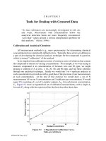
sharing computing resources and large collections of data. This is expressed
visually within Figure 10.1, where resources might include for example computing
power, databases and geographical services. Here, the Grid is a flexible cross-
organizational network where communications occur on a machine-machine basis
as opposed to the human-machine world of the Internet. Different ‘virtual
organizations’ form and dissipate with each use of the network, and the choice of
appropriate resources may itself be selected, as well as accessed, by machine rather
than human.
Figure 10.1 The general nature of virtual organizations in the ‘Grid’ (after Foster et al.
1
).
165
© 2008 by Taylor & Francis Group, LLC
166 GIS for environmental decision-making
More recently it has been suggested that ‘The ‘Grid’ … aims to provide an
infrastructure that enables flexible, secure, co-ordinated resource sharing among
dynamic collections of individuals, institutions and resources’
1
. This still
encompasses issues regarding computational systems and data storage, but is a
broader definition stressing collaborative (scientific) enterprise and transient virtual
organizations. These last points are critical. This rationale is a superset
encompassing both the earlier arguments in favor of intensive computing and also a
vision of the Grid’s potential to encourage changes to the very practice of science
itself. Adopting this wider stance, Table 10.1 highlights just a few of the areas in
which a Grid-enabled GIS might offer advantages over the status quo.
Table 10.1 Potential opportunities enabled by incorporating GIScience technologies within Grid
enabled systems
Data
•
Finding appropriate data sets
automatically
• Access to large data sets without
downloading them completely,
reducing data redundancy
• A potential means of linking data held
at multiple organizations
• Mobile and real time sensors as input
o Providing update through new
observation
o
o
To give information to decision
makers
Requiring new computation of models
Virtual organizations
•
A new way of carrying out
integrative modelling experiments
across multiple sites
• A means of bringing together
elements of GI applications that plays
to the strengths of individual
researchers who are freed by access
to appropriate interfaces
• A more equitable resourcing outcome,
both for researchers and governments?
Models and modelling
•
Access to models too complex to run
at the majority of locations
• A means of linking multiple models
without overloading one computer
system
• A means of linking models developed
at multiple sites without the
collocation of individuals or software
code
• Data mining for
associations/associated models
• Computing power to evaluate
sensitivity of simulation
models/evaluate uncertainties in
approach
Visualization for control,
monitoring and decision-making
•
Interactive, multi-site visualizations
to allow discussions of emerging
phenomena and to support multi-user
decisions
• Multiple views based on a similar
modelling flow, for example
researchers, farmers, advisors and
policy makers
• Visualization methods that might
assist with the monitoring of GRID
processing
© 2008 by Taylor & Francis Group, LLC
Grid-enabled GIS 167
Turning firstly to the left hand quadrants of Table 10.1, practical computational
challenges in the extent to which we are able to process increasing volumes of
satellite and other data and model inter-linked critical processes at global and
regional scales are perennial issues. The pooling of available computer resources
across international and institutional boundaries has the potential to allow us to
pursue previously intractable questions, reduce redundancy in data archives,
process uncertainty bounds on simulation runs and explore geographically localized
models
2
. The use of computational Grids for the processing of remotely sensed data
for example has seen early progress
3,4
. Alternatively, Grid services could be used to
speed up applied models to provide more responsive ‘real-time’ risk assessments
5
.
E-science technologies also offer the possibility of drawing on expertise, data,
knowledge and models in-situ in different parts of the world, opening opportunities
for increased interdisciplinary collaboration and a richer set of research and socio-
political perspectives. This may be deductive, or inductive through the further
facilitation of data mining opportunities that the Grid presents. Grid services of the
future for example should be able to find appropriate GIS models, functions and
data dynamically, a considerable step forward from the currently used Web
Services model.
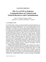
Putting some context to these possibilities, consider a Grid approach for
management and research regarding the causes and effects of urban atmospheric
sensors, computing power, models (geographical and non-geographical) and
expertise that are associated with these tasks. Many of these resources are currently
unconnected, either in terms of easy human access or web services, let alone via a
network. At present, an efficient flow of digital information to support, for
example, management of risk to asthmatics from localized extreme episodes or
responses to the threat of an impending critical episode is hampered by cross-
institutional and cross-disciplinary barriers. The types of entity that might form a
virtual organization in this case vary considerably in nature; the hospital expertise
and patient data of Figure 10.2 require strong controls on the access to personal
data to be in place
6
, while sensor and meteorological data have less restriction.
Work on Grid accessibility to this second type of data set is consequently more
advanced, for example through projects such as the ‘NERC DataGrid’ (see
Similar contrasts may be identified
between research and public service organizations, where progressing Grid services
is understandably more in keeping with the former at this early stage.
Hypothetically, advantages from all quadrants of Table 10.1 to adopting a Grid
approach in this application area can be identified. This is just one very brief
snapshot of the potential of cross-disciplinary and cross-institutional Grid
computing in the service of an application area; more details may be found
elsewhere
5
. Examples of on-going Grid work that incorporates GIS or remotely
© 2008 by Taylor & Francis Group, LLC
Grid; the bold lines in Figure 10.2 illustrate potential new connections across a Grid
pollution from traffic. Figure 10.2 identifies just some of the databases, automated
168 GIS for environmental decision-making
sensed data and/or functions and perspectives may be found in a diverse range of
subject areas connected with environmental decision-making, such as climate
modelling
7
, land-use change
8
and hydrological modelling
2
among others.
Figure 10.2 Inter-connected Grid resources for management and research regarding the causes and
effects of atmospheric pollution.
Before applying Grid-enabled GIS for science and decision making however,
we need to establish how close we really are to practicing GIS technologies on the
Grid. The reality is that many developments in computer science will be required if
data access, model integration and computing power are to be available and
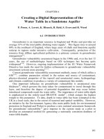
harnessed in a seamless and secure fashion. Figure 10.3 suggests a development
profile for Grid utilization in environmental science; currently, practice is moving
into the second stage but retains a data, as opposed to service, bias
7,9
that still also
exists at stage one. Thus, we should not lose sight of the fact that using the Grid to
support GIS applications currently requires considerable computing expertise on
the part of developers; the average GIS user is a long way from logging on to the
Grid in the same way that he or she logs on to a PC and searches the web.
© 2008 by Taylor & Francis Group, LLC
Grid-enabled GIS 169
Figure 10.3 Stages of development in Grid GIS for environmental decision-making.
This chapter focuses on the technical and indeed cultural aspects of GIScience
that might be further developed such that ‘doing’ interdisciplinary collaborative
work that incorporates GIS across the Grid is both seamless and straightforward in
the years to come. In other words, as Grid technologies mature, what does
GIScience need to research in order that GridGIS functionality will be available to
researchers and even to users who might not necessarily know that GIS
technologies are serving their requests? Issues of particular current importance in
meeting this goal are outlined in the right hand panel of Figure 10.3, and include
further research regarding the linked themes of metadata and ontologies, distributed
processing and federated databases. Work to assist users in managing remote data
and processes intelligently is also relatively immature in GIS
10
, while the area of
© 2008 by Taylor & Francis Group, LLC
170 GIS for environmental decision-making
collaborative analysis and spatial visualization
11
is also opening up as a dynamic
research area.
10.2 PROGRESS AND CHALLENGES
The challenges involved in realising the potential of Grid for applications
involving GIS are many. Firstly, as Figure 10.3 indicates, technical developments
will be required both from within and outside the GIScience arena if data access,
model integration and computing power are to be readily available in a seamless
and secure fashion. Secondly, there will be a need to review the way in which
research and data are managed, and to encourage ways of thinking and working that
support collaborative interdisciplinary science.
10.2.1 Technical Issues
Part of the remit of ‘e-Science’ is to build the infrastructure which delivers
efficient access to geographically distributed leading edge data storage,
computational and network resources. To date, this has involved a change of
orientation from the use of inter-connected super-computers towards a more
general concept of a ‘Grid’ of computational power
12
. The intention is that the
‘Grid’ architecture will use diverse, geographically distributed computers as if they
were a local resource, managed by software (termed ‘middleware’) that runs
between the ‘Grid’ and the local machines. Together, the infrastructure will be one
that ‘enables flexible, secure, co-ordinated resource sharing among dynamic
collections of individuals, institutions and resources’
12
. A toolkit named Globus
13
is
one example of emerging middleware. Emerging architectures for the Grid such as
the Open Grid Service Architecture (OGSA) have incorporated the features of Web
Services; the wide scale adoption of Web Services by the GIS community leaves it
particularly well placed to follow a Grid pathway in this respect.
At this point in time, references to ‘Grids’ rather than ‘the Grid’ are more
commonly found, and the pioneering work is being carried out on relatively small
clusters of distributed machines. This is because developing ‘the Grid’ holds many
technical challenges, from increasing network bandwidth and communication speed
to security and resource scheduling; as Figure 10.3 indicates, true dynamism falls a
step beyond what is currently feasible. Many of these issues fall beyond the
research of GIScientists, but will impact upon the sustainability of current interest
in the area. However, what emerges from the history of parallel processing and
Internet usage in GIS to date is that there will be emergent GIS-specific issues
relating to ‘doing’ GridGIS. Many of these fundamental GIScience issues can be
researched with a view to their application on more robust Grids of the future, but
with the expectation that smaller closed networks of resources will remain the
status quo for geographical and environmental applications for some while as our
understanding builds (Figure 10.3).
© 2008 by Taylor & Francis Group, LLC
Grid-enabled GIS 171
Fundamentally, if the opportunities presented by the Grid concept are to be
maximized, then computing using the Grid as opposed to any other computing
environment needs to be invisible. The applied user of GIS will not wish to grapple
with scheduling and task decomposition issues, obtrusive access requirements or
large seams between geographical databases. Additionally, just as how we see and
label our worlds is vital when searching for data
14
, any deficiencies and differences
in this are expected to become even more apparent when sourcing and using
networks of models and services from multiple disciplines. Furthermore, it will be
important to recognize that a significant amount of interdisciplinary science is
currently being carried out by researchers from one discipline stretching into the
domains of another. While GridGIS potentially offers an environment within which
research parties can access complementary expertise and work more fully towards
their individual strengths, we should also weigh how we can incorporate expert
geographical knowledge through hidden ‘intelligent’ infrastructures for providing
assistance with services and access to resources
10
. A further, and not
inconsiderable, GIScience challenge relates to how we communicate and manage
data, models and results designed across multiple scales and for various purposes.
10.2.1.1 Towards the ‘Invisible’ Grid: Semantics
Appropriate standards for metadata have been a subject of enquiry in the GI
world for some time, albeit rather focused on data
15
. This past focus on sharing data
and information rather than models and service resources has led to a paucity of
metadata schema and ontologies for geographical actions as opposed to objects,
although recent work has begun to close this gap
16-19
. The term ontology is used
here in the sense of a software engineering artifact used to describe a particular
domain, ‘An explicit specification of a conceptualization’
20
, as opposed to the more
philosophical “science of being”. Within a Grid context, further work regarding the
development of metadata and ontologies for activities and objects in combination
16
will be a valuable contribution. We also need to consider how metadata fields
might more easily be filled, for example using automated agents that mine
resource-use histories to assist with this time consuming process
21
. The
development of these semantic issues is important in building usable registries of
services that agents may find automatically across the Grid, for developing more
sophisticated data mining tools that move beyond the fixed registry approach and
for making appropriate use of data and services once found.
Within this research on ontology and metadata, further work remains to be done
regarding lineage, linking with Grid research on provenance. Additionally,
developing methods to identify the intended meaning of words
22
will be an
interesting challenge. Coming from the perspective of achieving improved
interdisciplinary working, Smith and Mark
23
note the benefits of being able to
account for differences in terminology for geographical processes and objects used
by geographers and others. It is likely that researchers in different spheres of
© 2008 by Taylor & Francis Group, LLC
172 GIS for environmental decision-making
geography will interact with models and geographical data in different ways, as
will decision makers. The question as to whether it is valuable to attempt to
concatenate local ontologies into global super-sets must be opened for debate, as
must the wisdom of adopting a hierarchical approach
24
to ontology building. For
flexibility, given the number of permutations in ontology likely to arise when
working in a global, interdisciplinary Grid context, it may be that pursuing methods
to bridge ontologies through dynamic negotiation according to context will be a
more fruitful avenue of research. Furthermore, incorporating changing contexts or
perceptions within ontologies will be a necessary challenge, given that no ontology
can ever be considered complete and immutable.
10.2.1.2 Towards the ‘Invisible’ Grid: Accessing and Scheduling GIS Procedures
As noted above, the average user of a GIS will not wish to grapple with many
of the technical issues involved in Grid computing. The aim must rather be one of
‘invisible computing’, where the tools ‘fit the person and tasks so well, are
sufficiently unobtrusive and inter-connectivity seamless, that the technological
details become virtually invisible compared to the task’
25
. Such an aim can only be
achieved by identifying and implementing appropriate Grid tools for geographical
contexts. This theme links with the intelligent GIS discussed below, but also
incorporates the more practical aspects of enabling and scheduling GI procedures.
Examples of geographical tools that will be desirable if we are to maximize the
potential of the Grid include a comprehensive and accessible set of web services for
GI functions that match those available in current GIS and beyond, and which
dovetail with Grid middleware. Additionally, the creation of toolkits and
frameworks that simplify model development for the Grid, such that the current
extra effort in wrapping a model as a grid service is removed, might do much to
make Grid computing a viable alternative for modellers
5
.
A wide range of methods for specifying the processing sequence or ‘workflow’,
that will collate and order services, is currently under investigation throughout the
Grid literature
26
. Scheduling algorithms that distribute the modelling tasks specified
in the workflow across multiple machines are a fundamental component of
developing the Grid from a computer science perspective. This distribution will
vary according to the geographical and temporal configuration of the task and
resources available at any one point in time. Investigation of how these scheduling
algorithms support spatial processing in particular will be useful; both previous
research ‘parallelizing’ GI tasks
27
and more recent Grid-focused work
28,29
suggests
that optimizing the way in which geographical modelling tasks are decomposed and
scheduled over multiple machines may be specific to the spatial context. Indeed,
understanding the changing space-time geographies of the Grid itself is likely to
prove an interesting research area, since ‘data “locality” can seriously affect
performance’
30
.
© 2008 by Taylor & Francis Group, LLC
Grid-enabled GIS 173
10.2.1.3 Intelligent Infrastructures
A considerable amount of interdisciplinary science is currently being carried out
by those of one discipline stretching into the domains of another. While the Grid
potentially offers an environment within which research parties can access
complementary expertise and work more fully towards their individual strengths,
we also need to consider how we can incorporate expert geographical knowledge
through hidden ‘intelligent’ infrastructures to provide assistance with services and
access to resources. At one level, this might involve metadata structures for
services that encode their assumptions for use or by wrapping intelligent agents
with services or data sets; at a more advanced level, the bigger challenge is to
associate geographical questions expressed in natural language with appropriate
workflows that are able solve the problem automatically using Grid-enabled
resources.
The dangers of providing access to specialist models or resources to non-
specialists have been highlighted by Anselin
31, p14-15
among others. Anselin for
example suggests, in the context of spatial analysis functions, that ‘with the vast
power of a user friendly GIS increasingly in the hands of the non specialist, the
danger that the wrong kind of spatial statistics will become the accepted practice is
great’. Seventeen years on, the creation of more ‘intelligent’ GIS and modelling
tools to support decision makers, long identified as a priority for basic research
within the environmental modelling community
32,33
, remains largely unachieved.
Concepts of knowledge networking, essentially a means of aggregating expertise,
knowledge and information, have emerged in relation to diabetes
34
and social
medicine
35
and point to possibilities for the development of ‘intelligent’
geographical tools for access across the Grid. However, how we encode what is
often incomplete knowledge and how we evaluate versions of encoded knowledge
according to their nature (e.g., prediction or interpretation) and quality are
questions for further research. Case-based reasoning methods have been used to
build inductive rules, models and more recently workflow procedures
36
, and these
complement the more formal encoding of deductively-derived cognitive
knowledge
10
. Research regarding how best to link local networks and work towards
global theories across spatial scales and multiple disciplines will be needed if this
‘knowledge network’ model is to be used as a basis for ‘intelligent’ collaborative
support tools. Furthermore, as Zhuge
37
notes, a semantically-enabled grid is a
necessary precursor to an effective knowledge grid.
10.2.2 Cultural Issues
It has been suggested that ‘e-Science is about global collaboration in key areas
of science, and the next generation of infrastructure that will enable it’
38
. Gober
39
is
among those who argue in a broader geographical context for the need for cultural
changes and the more thorough integration of specialisms.
© 2008 by Taylor & Francis Group, LLC
174 GIS for environmental decision-making
10.2.2.1 Interdisciplinary Practice
Issues that are likely to arise in the context of interdisciplinary modelling over
the Grid, such as the need to develop theories of scale that facilitate the linking of
economic and environmental models, and the better forging of links between
qualitative and quantitative research, provoke questions central to geography as a
discipline. It will be important for research under the banner of e-science in GIS to
be more than a consideration of technical issues, and moreover it must not hinge
simply on our ability to add together the ‘sum of the parts’ as an extension of the
status quo.
10.2.2.2 Collaborative Human–Computer Interaction
If we are to use the Grid as a collaborative tool, then the design of interactive
collaborative and multi-agency tools and research related to visual decision-making
will be important undertakings. Developments in collaborative decision-making
between different types of agency
40,41
could usefully be extended to Grid media to
support smaller-scale collaborative research amongst research communities. More
generic work, such as the “Access Grid” Project (
http://www-
fp.mcs.anl.gov/fl/Accessgrid/
) which ‘provide(s) a research environment for the
development of distributed data and visualization corridors and for studying issues
relating to collaborative work in distributed environments’, indicates starting points
for such research. MacEachren
42
provides a thorough overview of work in this
collaborative visualization domain from a geographical perspective, and draws up a
conceptual framework for collaborative geographic visualization that explicitly
incorporates scientific as well as decision-making collaborative environments. The
dynamics of human, versus computer, interaction need to be pursued in a manner
that explicitly considers geographical tasks by a variety of actors. While the
concept of the ‘collaboratory’
43
, or virtual collaborative working environment, has
yet to be explicitly implemented within geography, we should bear in mind that, of
recent attempts at developing collaboratories, some do not succeed because
‘distance still matters’
44
.
10.2.2.3 Geographically-Distributed Research
In looking to integrate research across disciplines, we must avoid the irony of
geographically-distributed research issuing from a very limited number of locations
and viewpoints. In this sense, it seems that technical and cultural changes need to
go hand in hand if we are to succeed with GridGIS. The pursuit of technical
geographies can assist in ensuring that structural and software developments in e-
science are ‘geographically enabled’, such that they provide a supportive and
potentially more democratic platform for greater collaboration, but firstly this
attitudinal shift needs to take place.
© 2008 by Taylor & Francis Group, LLC
Grid-enabled GIS 175
10.2.2.4 Data Access, Power and Purchasing
Significantly, attitudes towards data access and variations in quality and
quantity of digital data already impede global collaboration
45
. Moreover, the profile
of organizational agendas, control over data, privacy issues, charges for ‘public’
data and political interests within geography raised by Pickles
46
are accentuated
within our increasingly Internet-enabled societies. In moving to an environment of
e-services, a world in which payments for the use of GIS software and data
components are made on demand with each use, such contentions are likely to
multiply
47
. Changes in the business model on which GI software stands will be
inevitable.
Issues such as the ownership of knowledge, and the cost of encoding it, might
also be expected to become important research issues given such an expected
marked change in the design and use of computational and knowledge acquisition
resources. For example, in relation to ‘formal’ knowledge, the question is being
asked as to whether the days of refereed textual articles are numbered, to be
replaced by entries in knowledge ‘repositories’. Such viewpoints highlight the
changing cultural contexts of scientific research provoked by e-science concepts.
Just as the adoption of e-science is likely to affect the practice of research, new
economic and social geographies are likely to emerge in its wake.
10.3 CONCLUSIONS
The adoption of an e-science framework within which to carry out GIS
applications offers potential gains by providing access to both data, knowledge and
the computer resources with which to process them in a tractable fashion. These
same resources offer the potential for geographers to offer relevant, timely findings
to decision and policy makers for risk management and mitigation. Arguably then,
the e-science manifesto suits GIS well. However, we need to review our current
progress through the stages of development required for full and easy use of the
Grid by GI practitioners and users (Figure10.3); the technical and attitudinal
challenges posed by the Grid at its current stage of development are many, and a
long term view as to what might be possible is required.
Research regarding the ontologies of geography, and the way in which
geographies are practiced and perceived by different peoples and at different
locations, will be crucial if the overhead of carrying out e-science by geographers is
not to be too great. So too will theoretical research regarding the ‘invisible’
management of geographical modelling tasks at a variety of levels across multiple
resources. Culturally, fostering shifts towards greater interdisciplinary and
geographical collaboration is an important goal as is work challenging some
existing attitudes towards the sharing of data, knowledge and resources.
Arguably, it is the notions of collaborative scientific enterprise, semantic
expression and ‘invisible’ computing which most stretch our current notions of
© 2008 by Taylor & Francis Group, LLC
176 GIS for environmental decision-making
GIScience. This chapter began by noting two definitions of Grid computing. The
significance of the second definition stressing the virtual organization still requires
yet stronger emphasis if progress towards doing GIS over the Grid is not to be
thwarted, since there may be a lack of immediately applicable ‘big’ compute-
intensive applications. The Grid’s potential to empower using remote resources and
interdisciplinary communication must also be further evaluated if Grid GIS is to
prosper. Linked to this theme, we also need to keep a careful watch on issues of
democracy in research, security, intellectual property and privacy when moving
more closely towards such a component-based, global digital research world.
The Grid has the potential to provide the technical support for exciting new
developments in relevant, global geographies for the 22
nd
Century. However, in
closing, it is important to note that empirical geography supported by Grid must be
matched by developments in theory, particularly in relation to how we integrate
across scales and between disciplines, if we are not simply to achieve a faster ‘old’
geography or a collection of small components pushed together instead of a
dynamic new version.
10.4 REFERENCES
1.
Foster, I., Kesselman, C., and Tueke, S., The anatomy of the Grid: Enabling scalable virtual
organisations, International Journal of Supercomputer Applications, 15, 200-222, 2001.
2.
Beven, K. J., On environmental models everywhere on the Grid, Hydrological Processes, 17, 171-174,
2003.
3.
Aloisio, G. and Cafaro, M., A dynamic earth observation system, Parallel Computing, 29, 1357-1362,
2003.
4.
Shen, Z., Luo, J., Zhou, C., Cai, S., Zheng, J., Chen, Q., Ming, D., and Sun, Q., Architecture design of
grid GIS and its applications on image processing based on LAN, Information Sciences, 166, 1-17,
2004.
5.
Mineter, M. J., Dowers, S., Skouloudis, A. N., and Jarvis, C. H., Towards use of grids in
environmental research, management and policy, International Journal of Environment and Pollution,
20, 297-308, 2003.
6.
Hartswood, M., Ho, K., Procter, R., Slack, R., and Voss, A., Etiquettes of data sharing in healthcare
and healthcare research, in Proceedings of the 1st International Conference of E-Social Science,
Manchester, UK, 2005.
7.
Chervenak, A., Deelman, E., Kesselman, C., Allcock, B., Foster, I., Nefedova, V., Lee, J., Sim, A.,
Shoshani, A., and Drach, B., High-performance remote access to climate simulation data: a challenge
problem for data grid technologies, Parallel Computing, 29, 1335-1356, 2003.
8.
Edwards, P., Preece, A., Pignotti, E., Polhill, G., and Gotts, N., Lessons learnt from deployment of a
social simulation tool to the semantic Grid, in Proceedings of the 1st International Conference of E-
Social Science, Manchester, UK, 2005.
9.
Ananthanarayan, A., Balachandram, R., Grossman, R., Gu, Y., Hong, X., Levera, J., and Mazzucco,
M., Data webs for earth science data, Parallel Computing, 29, 1363-1379, 2003.
© 2008 by Taylor & Francis Group, LLC
Grid-enabled GIS 177
10.
Jarvis, C. H., Stuart, N., and Cooper, W., Infometric and statistical diagnostics to provide artificially-
intelligent support for spatial analysis: the example of interpolation, International Journal of
Geographical Information Science, 17, 495-516, 2003.
11.
MacEachren, A. M., Cartography and GIS: extending collaborative tools to support virtual teams,
Progress in Human Geography, 25, 431-444, 2001.
12.
Foster, I. and Kesselman, C., The Grid: Blueprint for a New Computing Infrastructure, Morgan
Kaufmann, New York, 1999.
13.
Foster, I. and Kesselman, C., Globus: a metacomputing infrastructure toolkit, International Journal of
Supercomputer Applications, 11, 115-128, 1997.
14.
Mark, D. M., Freksa, C., Hirtle, S. C., Lloyd, R., and Tversky, B., Cognitive models of geographic
space, International Journal of Geographical Information Science, 13, 747-774, 1999.
15.
Maguire, D. J. and Longley, P. A., The emergence of geoportals and their role in spatial data
infrastructures, Computers, Environment and Urban Systems, 29, 3-14, 2005.
16.
Kuhn, W., Ontologies in support of activities in geographical space, International Journal of
Geographical Information Science, 15, 613-631, 2001.
17.
Soon, K. and Kuhn, W., Formalizing user actions for ontologies, in Geographic Information Science,
Proceedings 2004, University of Maryland, 2004, 299-312.
18.
Duckham, M. and Worboys, M., An algebraic approach to automated geospatial information fusion,
International Journal of Geographical Information Science, 19, 537-557, 2005.
19.
Schade, S., Sahlmann, A., Lutz, M., Probst, F., and Kuhn, W., Comparing approaches for semantic
service description and matchmaking, in On the Move to Meaningful Internet Systems 2004: Coopls,
Doa, and Odbase, Pt 2, Proceedings, 2004, 1062-1079.
20.
Gruber, T. R., A translation approach to portable ontologies, Knowledge Acquisition, 5, 199-220,
1993.
21.
Gahegan, M. and Pike, W., A situated representation of GIS resources, in Annual Meeting of the
Association of American Geographers, Denver, US, 2005.
22.
Comber, A., Fisher, P., and Wadsworth, R., What is land cover?, Environment and Planning B:
Planning and Design, 32, 199-209, 2005.
23.
Smith, B. and Mark, D. M., Geographical categories: an ontological investigation, International
Journal of Geographical Information Science, 15, 591-612, 2001.
24.
Kokla, M. and Kavouras, M., Fusion of top-level and geographical domain ontologies based on
context formation and complementarity, International Journal of Geographical Information Science, 15,
679-687, 2002.
25.
Pawlikowski, K., Call for papers for InviCom 2001: International Workshop on Invisible Computing,
May 16-18, Brisbane, Australia,
ressim /msg00007.html, 2001.
26.
Yu, H., Bai, X., and Marinescu, D. C., Workflow management and resource discovery for an
intelligent grid, Parallel Computing, 31, 797-811, 2005.
27.
Mineter, M. J., Dowers, S., and Gittings, B. M., Towards a HPC framework for integrated processing
of geographical data: encapsulating the complexity of parallel algorithms, Transactions in GIS, 4, 245-
262, 2000.
© 2008 by Taylor & Francis Group, LLC
178 GIS for environmental decision-making
28.
Hu, Y. C., Xue, Y., Wang, J. Q., Sun, X. S., Cai, G. Y., Tang, J. K., Luo, Y. W., Zhong, S. B., Wang,
Y. G., and Zhang, A. J., Feasibility study of geo-spatial analysis using Grid computing, Computational
Science. Lecture Notes in Computer Science, 3039, 956-963, 2004.
29.
Wang, S. and Armstrong, M. P., A quadtree approach to domain decomposition for spatial
interpolation in Grid computing environments, Parallel Computing, 29, 1481-1504, 2003.
30.
Armstrong, M. P., Geography and computational science, Annals of the Association of American
Geographers, 90, 146-156, 2000.
31.
Anselin, L., What is Special About Spatial Data? Alternative Perspectives on Spatial Data Analysis,
NCGIA Technical Report 89/4, NCGIA, Santa Barbara, 1989.
32.
Burrough, P. A., Development of intelligent geographical information systems, International Journal
of Geographical Information Systems, 6, 1-11, 1992.
33.
Densham, P. J. and Goodchild, M. F., Spatial decision support systems: a research agenda, in
Proceedings of GIS/LIS'89, ACSM/ASPRS/AAG, Virginia, 1989, 707-716.
34.
Uelpenich, S. and Bodendorf, F., Knowledge organisation and knowledge modelling in consulting
companies, Wirtschaftsinformatik, 43, 469, 2001.
35.
Cravey, A. J., Washburn, S. A., Gesler, W. M., Arcury, T. A., and Skelly, A. H., Developing socio-
spatial knowledge networks: a qualitative methodology for chronic disease prevention, Social Science
and Medicine, 52, 1763-1775, 2001.
36.
Kaster, D. S., Medeiros, C. B., and Rocha, H. V., Supporting modeling and problem solving from
precedent experiences: the role of workflows and case-based reasoning, Environmental Modelling and
Software, 20, 689-704, 2005.
37.
Zhuge, H., Semantics, Resource and Grid, Future Generation Computer Systems, 20, 1-5, 2004.
38.
Taylor, J., Director-General of the Research Councils, OST, , 2002.
39.
Gober, P., In search of synthesis, Annals of the Association of American Geographers, 90, 1-11, 2000.
40.
Jankowski, P. and Nyerges, T., GIS-supported collaborative decision making: results of an
experiment, Annals of the Association of American Geographers, 91, 48-70, 2000.
41.
Churcher, C. and Churcher, N., Realtime conferencing in GIS, Transactions in GIS, 3, 23-30, 1999.
42.
MacEachren, A. M., Cartography and GIS: extending collaborative tools to support virtual teams,
Progress in Human Geography, 25, 431-444, 2001.
43.
Kouzes, R., Myers, J., and Wulf, W., Collaboratories: doing science on the Internet, Computer, 29,
40-46, 1996.
44.
Olson, G. M. and Olson, J. S., Distance matters, Human-Computer Interaction, 15, 139-178, 2000.
45.
Hulme, M., Global warming, Progress in Physical Geography, 24, 591-599, 2000.
46.
Pickles, J., Ground Truth, Guildford Press, New York, 1995.
47.
Braynov, S. and Sandholm, T., Contracting with uncertain level of trust, Computational Intelligence,
18, 501-514, 2002.
© 2008 by Taylor & Francis Group, LLC