Understanding GPS Principles and Applications Second Edition
Bạn đang xem bản rút gọn của tài liệu. Xem và tải ngay bản đầy đủ của tài liệu tại đây (8.16 MB, 723 trang )
Understanding GPS
Principles and Applications
Second Edition
For a listing of recent titles in the Artech House
Mobile Communications Series, turn to the back of this book.
Understanding GPS
Principles and Applications
Second Edition
Elliott D. Kaplan
Christopher J. Hegarty
Editors
artechhouse.com
Library of Congress Cataloging-in-Publication Data
Understanding GPS: principles and applications/[editors], Elliott Kaplan,
Christopher Hegarty.—2nd ed.
p. cm.
Includes bibliographical references.
ISBN 1-58053-894-0 (alk. paper)
1. Global Positioning System. I. Kaplan, Elliott D. II. Hegarty, C. (Christopher J.)
G109.5K36 2006
623.89’3—dc22
2005056270
British Library Cataloguing in Publication Data
Kaplan, Elliott D.
Understanding GPS: principles and applications.—2nd ed.
1. Global positioning system
I. Title II. Hegarty, Christopher J.
629’.045
ISBN-10: 1-58053-894-0
Cover design by Igor Valdman
Tables 9.11 through 9.16 have been reprinted with permission from ETSI. 3GPP TSs and TRs
are the property of ARIB, ATIS, ETSI, CCSA, TTA, and TTC who jointly own the copyright
to them. They are subject to further modifications and are therefore provided to you “as is”
for informational purposes only. Further use is strictly prohibited.
© 2006 ARTECH HOUSE, INC.
685 Canton Street
Norwood, MA 02062
All rights reserved. Printed and bound in the United States of America. No part of this book
may be reproduced or utilized in any form or by any means, electronic or mechanical, including photocopying, recording, or by any information storage and retrieval system, without
permission in writing from the publisher.
All terms mentioned in this book that are known to be trademarks or service marks have
been appropriately capitalized. Artech House cannot attest to the accuracy of this information. Use of a term in this book should not be regarded as affecting the validity of any trademark or service mark.
International Standard Book Number: 1-58053-894-0
10 9 8 7 6 5 4 3 2 1
To my wife Andrea, whose limitless love and support enabled
my contribution to this work. She is my shining star.
—Elliott D. Kaplan
To my family—Patti, Michelle, David, and Megan—
for all their encouragement and support
—Christopher J. Hegarty
Contents
Preface
Acknowledgments
CHAPTER 1
Introduction
xv
xvii
1
1.1 Introduction
1.2 Condensed GPS Program History
1.3 GPS Overview
1.3.1 PPS
1.3.2 SPS
1.4 GPS Modernization Program
1.5 GALILEO Satellite System
1.6 Russian GLONASS System
1.7 Chinese BeiDou System
1.8 Augmentations
1.9 Markets and Applications
1.9.1 Land
1.9.2 Aviation
1.9.3 Space Guidance
1.9.4 Maritime
1.10 Organization of the Book
References
1
2
3
4
4
5
6
7
8
10
10
11
12
13
14
14
19
CHAPTER 2
Fundamentals of Satellite Navigation
21
2.1 Concept of Ranging Using TOA Measurements
2.1.1 Two-Dimensional Position Determination
2.1.2 Principle of Position Determination Via
Satellite-Generated Ranging Signals
2.2 Reference Coordinate Systems
2.2.1 Earth-Centered Inertial Coordinate System
2.2.2 Earth-Centered Earth-Fixed Coordinate System
2.2.3 World Geodetic System
2.2.4 Height Coordinates and the Geoid
2.3 Fundamentals of Satellite Orbits
2.3.1 Orbital Mechanics
2.3.2 Constellation Design
2.4 Position Determination Using PRN Codes
2.4.1 Determining Satellite-to-User Range
2.4.2 Calculation of User Position
21
21
24
26
27
28
29
32
34
34
43
50
51
54
vii
viii
Contents
2.5 Obtaining User Velocity
2.6 Time and GPS
2.6.1 UTC Generation
2.6.2 GPS System Time
2.6.3 Receiver Computation of UTC (USNO)
References
58
61
61
62
62
63
CHAPTER 3
GPS System Segments
67
3.1 Overview of the GPS System
3.1.1 Space Segment Overview
3.1.2 Control Segment (CS) Overview
3.1.3 User Segment Overview
3.2 Space Segment Description
3.2.1 GPS Satellite Constellation Description
3.2.2 Constellation Design Guidelines
3.2.3 Space Segment Phased Development
3.3 Control Segment
3.3.1 Current Configuration
3.3.2 CS Planned Upgrades
3.4 User Segment
3.4.1 GPS Set Characteristics
3.4.2 GPS Receiver Selection
References
67
67
68
68
68
69
71
71
87
88
100
103
103
109
110
CHAPTER 4
GPS Satellite Signal Characteristics
113
4.1 Overview
4.2 Modulations for Satellite Navigation
4.2.1 Modulation Types
4.2.2 Multiplexing Techniques
4.2.3 Signal Models and Characteristics
4.3 Legacy GPS Signals
4.3.1 Frequencies and Modulation Format
4.3.2 Power Levels
4.3.3 Autocorrelation Functions and Power Spectral Densities
4.3.4 Cross-Correlation Functions and CDMA Performance
4.4 Navigation Message Format
4.5 Modernized GPS Signals
4.5.1 L2 Civil Signal
4.5.2 L5
4.5.3 M Code
4.5.4 L1 Civil Signal
4.6 Summary
References
113
113
113
115
116
123
123
133
135
140
142
145
145
147
148
150
150
150
Contents
ix
CHAPTER 5
Satellite Signal Acquisition, Tracking, and Data Demodulation
153
5.1 Overview
5.2 GPS Receiver Code and Carrier Tracking
5.2.1 Predetection Integration
5.2.2 Baseband Signal Processing
5.2.3 Digital Frequency Synthesis
5.2.4 Carrier Aiding of Code Loop
5.2.5 External Aiding
5.3 Carrier Tracking Loops
5.3.1 Phase Lock Loops
5.3.2 Costas Loops
5.3.3 Frequency Lock Loops
5.4 Code Tracking Loops
5.5 Loop Filters
5.6 Measurement Errors and Tracking Thresholds
5.6.1 PLL Tracking Loop Measurement Errors
5.6.2 FLL Tracking Loop Measurement Errors
5.6.3 C/A and P(Y) Code Tracking Loop Measurement Errors
5.6.4 Modernized GPS M Code Tracking Loop Measurement Errors
5.7 Formation of Pseudorange, Delta Pseudorange, and Integrated Doppler
5.7.1 Pseudorange
5.7.2 Delta Pseudorange
5.7.3 Integrated Doppler
5.8 Signal Acquisition
5.8.1 Tong Search Detector
5.8.2 M of N Search Detector
5.8.3 Direct Acquisition of GPS Military Signals
5.9 Sequence of Initial Receiver Operations
5.10 Data Demodulation
5.11 Special Baseband Functions
5.11.1 Signal-to-Noise Power Ratio Meter
5.11.2 Phase Lock Detector with Optimistic and Pessimistic Decisions
5.11.3 False Frequency Lock and False Phase Lock Detector
5.12 Use of Digital Processing
5.13 Considerations for Indoor Applications
5.14 Codeless and Semicodeless Processing
References
153
155
158
159
161
162
164
164
165
166
170
173
179
183
184
192
194
199
200
201
216
218
219
223
227
229
231
232
233
233
233
235
235
237
239
240
CHAPTER 6
Interference, Multipath, and Scintillation
243
6.1 Overview
6.2 Radio Frequency Interference
6.2.1 Types and Sources of RF Interference
6.2.2 Effects of RF Interference on Receiver Performance
6.2.3 Interference Mitigation
6.3 Multipath
243
243
244
247
278
279
x
Contents
6.3.1 Multipath Characteristics and Models
6.3.2 Effects of Multipath on Receiver Performance
6.3.3 Multipath Mitigation
6.4 Ionospheric Scintillation
References
281
285
292
295
297
CHAPTER 7
Performance of Stand-Alone GPS
301
7.1 Introduction
7.2 Measurement Errors
7.2.1 Satellite Clock Error
7.2.2 Ephemeris Error
7.2.3 Relativistic Effects
7.2.4 Atmospheric Effects
7.2.5 Receiver Noise and Resolution
7.2.6 Multipath and Shadowing Effects
7.2.7 Hardware Bias Errors
7.2.8 Pseudorange Error Budgets
7.3 PVT Estimation Concepts
7.3.1 Satellite Geometry and Dilution of Precision in GPS
7.3.2 Accuracy Metrics
7.3.3 Weighted Least Squares (WLS)
7.3.4 Additional State Variables
7.3.5 Kalman Filtering
7.4 GPS Availability
7.4.1 Predicted GPS Availability Using the Nominal 24-Satellite
GPS Constellation
7.4.2 Effects of Satellite Outages on GPS Availability
7.5 GPS Integrity
7.5.1 Discussion of Criticality
7.5.2 Sources of Integrity Anomalies
7.5.3 Integrity Enhancement Techniques
7.6 Continuity
7.7 Measured Performance
References
301
302
304
305
306
308
319
319
320
321
322
322
328
332
333
334
334
335
337
343
345
345
346
360
361
375
CHAPTER 8
Differential GPS
379
8.1 Introduction
8.2 Spatial and Time Correlation Characteristics of GPS Errors
8.2.1 Satellite Clock Errors
8.2.2 Ephemeris Errors
8.2.3 Tropospheric Errors
8.2.4 Ionospheric Errors
8.2.5 Receiver Noise and Multipath
8.3 Code-Based Techniques
8.3.1 Local-Area DGPS
379
381
381
382
384
387
390
391
391
Contents
xi
8.3.2 Regional-Area DGPS
8.3.3 Wide-Area DGPS
8.4 Carrier-Based Techniques
8.4.1 Precise Baseline Determination in Real Time
8.4.2 Static Application
8.4.3 Airborne Application
8.4.4 Attitude Determination
8.5 Message Formats
8.5.1 Version 2.3
8.5.2 Version 3.0
8.6 Examples
8.6.1 Code Based
8.6.2 Carrier Based
References
394
395
397
398
418
420
423
425
425
428
429
429
450
454
CHAPTER 9
Integration of GPS with Other Sensors and Network Assistance
459
9.1 Overview
9.2 GPS/Inertial Integration
9.2.1 GPS Receiver Performance Issues
9.2.2 Inertial Sensor Performance Issues
9.2.3 The Kalman Filter
9.2.4 GPSI Integration Methods
9.2.5 Reliability and Integrity
9.2.6 Integration with CRPA
9.3 Sensor Integration in Land Vehicle Systems
9.3.1 Introduction
9.3.2 Review of Available Sensor Technology
9.3.3 Sensor Integration Principles
9.4 Network Assistance
9.4.1 Historical Perspective of Assisted GPS
9.4.2 Requirements of the FCC Mandate
9.4.3 Total Uncertainty Search Space
9.4.4 GPS Receiver Integration in Cellular Phones—Assistance Data
from Handsets
9.4.5 Types of Network Assistance
References
459
460
460
464
466
470
488
489
491
491
496
515
522
526
528
535
540
543
554
CHAPTER 10
GALILEO
559
10.1 GALILEO Program Objectives
10.2 GALILEO Services and Performance
10.2.1 Open Service (OS)
10.2.2 Commercial Service (CS)
10.2.3 Safety of Life (SOL) Service
10.2.4 Public Regulated Service (PRS)
10.2.5 Support to Search and Rescue (SAR) Service
559
559
560
562
562
562
563
xii
Contents
10.3 GALILEO Frequency Plan and Signal Design
10.3.1 Frequencies and Signals
10.3.2 Modulation Schemes
10.3.3 SAR Signal Plan
10.4 Interoperability Between GPS and GALILEO
10.4.1 Signal in Space
10.4.2 Geodetic Coordinate Reference Frame
10.4.3 Time Reference Frame
10.5 System Architecture
10.5.1 Space Segment
10.5.2 Ground Segment
10.6 GALILEO SAR Architecture
10.7 GALILEO Development Plan
References
563
563
565
576
577
577
578
578
579
581
585
591
592
594
CHAPTER 11
Other Satellite Navigation Systems
595
11.1 The Russian GLONASS System
11.1.1 Introduction
11.1.2 Program Overview
11.1.3 Organizational Structure
11.1.4 Constellation and Orbit
11.1.5 Spacecraft Description
11.1.6 Ground Support
11.1.7 User Equipment
11.1.8 Reference Systems
11.1.9 GLONASS Signal Characteristics
11.1.10 System Accuracy
11.1.11 Future GLONASS Development
11.1.12 Other GLONASS Information Sources
11.2 The Chinese BeiDou Satellite Navigation System
11.2.1 Introduction
11.2.3 Program History
11.2.4 Organization Structure
11.2.5 Constellation and Orbit
11.2.6 Spacecraft
11.2.7 RDSS Service Infrastructure
11.2.8 RDSS Navigation Services
11.2.9 RDSS Navigation Signals
11.2.10 System Coverage and Accuracy
11.2.11 Future Developments
11.3 The Japanese QZSS Program
11.3.1 Introduction
11.3.2 Program Overview
11.3.3 Organizational Structure
11.3.4 Constellation and Orbit
11.3.5 Spacecraft Development
595
595
595
597
597
599
602
604
605
606
611
612
614
615
615
616
617
617
617
618
621
622
623
623
625
625
625
626
626
627
Contents
xiii
11.3.6 Ground Support
11.3.7 User Equipment
11.3.8 Reference Systems
11.3.9 Navigation Services and Signals
11.3.10 System Coverage and Accuracy
11.3.11 Future Development
Acknowledgments
References
628
628
628
628
629
629
630
630
CHAPTER 12
GNSS Markets and Applications
635
12.1 GNSS: A Complex Market Based on Enabling Technologies
12.1.1 Market Scope, Segmentation, and Value
12.1.2 Unique Aspects of GNSS Market
12.1.3 Market Limitations, Competitive Systems, and Policy
12.2 Civil Navigation Applications of GNSS
12.2.1 Marine Navigation
12.2.2 Air Navigation
12.2.3 Land Navigation
12.3 GNSS in Surveying, Mapping, and Geographical Information Systems
12.3.1 Surveying
12.3.2 Mapping
12.3.3 GIS
12.4 Recreational Markets for GNSS-Based Products
12.5 GNSS Time Transfer
12.6 Differential Applications and Services
12.6.1 Precision Approach Aircraft Landing Systems
12.6.2 Other Differential Systems
12.6.3 Attitude Determination Systems
12.7 GNSS and Telematics and LBS
12.8 Creative Uses for GNSS
12.9 Government and Military Applications
12.9.1 Military User Equipment—Aviation, Shipboard, and Land
12.9.2 Autonomous Receivers—Smart Weapons
12.9.3 Space Applications
12.9.4 Other Government Applications
12.10 User Equipment Needs for Specific Markets
12.11 Financial Projections for the GNSS Industry
References
635
638
639
640
641
642
645
646
647
648
648
649
650
650
650
651
651
652
652
654
654
655
656
657
657
657
660
661
APPENDIX A
Least Squares and Weighted Least Squares Estimates
663
Reference
664
APPENDIX B
Stability Measures for Frequency Sources
665
B.1
665
Introduction
xiv
Contents
B.2
B.3
Frequency Standard Stability
Measures of Stability
B.3.1 Allan Variance
B.3.2 Hadamard Variance
References
665
667
667
667
668
APPENDIX C
Free-Space Propagation Loss
669
C.1 Introduction
C.2 Free-Space Propagation Loss
C.3 Conversion Between PSDs and PFDs
References
669
669
673
673
About the Authors
675
Index
683
Preface
Since the writing of the first edition of this book, usage of the Global Positioning
System (GPS) has become nearly ubiquitous. GPS provides the position, velocity,
and timing information that enables many applications we use in our daily lives.
GPS is in the midst of an evolutionary development that will provide increased accuracy and robustness for both civil and military users. The proliferation of augmentations and the development of other systems, including GALILEO, have also
significantly changed the landscape of satellite navigation. These significant events
have led to the writing of this second edition.
The objective of the second edition, as with the first edition, is to provide the
reader with a complete systems engineering treatment of GPS. The authors are a
multidisciplinary team of experts with practical experience in the areas that each
addressed within this text. They provide a thorough treatment of each topic. Our
intent in this new endeavor was to bring the first edition text up to date. This was
achieved through the modification of some of the existing material and through the
extensive addition of new material.
The new material includes satellite constellation design guidelines, descriptions
of the new satellites (Block IIR, Block IIR-M, Block IIF), a comprehensive treatment
of the control segment and planned upgrades, satellite signal modulation characteristics, descriptions of the modernized GPS satellite signals (L2C, L5, and M code),
and advances in GPS receiver signal processing techniques. The treatment of interference effects on legacy GPS signals from the first edition is greatly expanded, and a
treatment of interference effects on the modernized signals is newly added. New
material is also included to provide in-depth discussions on multipath and ionospheric scintillation, along with the associated effects on the GPS signals.
GPS accuracy has improved significantly within the past decade. This text presents updated error budgets for both the GPS Precise Positioning and Standard Positioning Services. Also included are measured performance data, a discussion on
continuity of service, and updated treatments of availability and integrity.
The treatment of differential GPS from the first edition has been greatly
expanded. The variability of GPS errors with geographic location and over time is
thoroughly addressed. Also new to this edition are a discussion of attitude determination using carrier phase techniques, a detailed description of satellite-based augmentation systems (e.g., WAAS, MSAS, and EGNOS), and descriptions of many
other operational or planned code- and carrier-based differential systems.
The incorporation of GPS into navigation systems that also rely on other sensors continues to be a widespread practice. The material from the first edition on
integrating GPS with inertial and automotive sensors is significantly expanded.
New to the second edition is a thorough treatment on the embedding of GPS receivers within cellular handsets. This treatment includes an elaboration on networkassistance methods.
xv
xvi
Preface
In addition to GPS, we now cover GALILEO with as much detail as possible at
this stage in this European program’s development. We also provide coverage of
GLONASS, BeiDou, and the Japanese Quasi-Zenith Satellite System.
As in the first edition, the book is structured such that a reader with a general
science background can learn the basics of GPS and how it works within the first few
chapters, whereas the reader with a stronger engineering/scientific background will
be able to delve deeper and benefit from the more in-depth technical material. It is
this “ramp up” of mathematical/technical complexity, along with the treatment of
key topics, that enable this publication to serve as a student text as well as a reference source. More than 10,000 copies of the first edition have been sold throughout
the world. We hope that the second edition will build upon the success of the first,
and that this text will prove to be of value to the rapidly increasing number of engineers and scientists that are working on applications involving GPS and other satellite navigation systems.
While the book has generally been written for the engineering/scientific community, one full chapter is devoted to Global Navigation Satellite System (GNSS) markets and applications. This is a change from the first edition, where we focused
solely on GPS markets and applications. The opinions presented here are those of
the authors and do not necessarily reflect the views of The MITRE Corporation.
Acknowledgments
Much appreciation is extended to the following individuals for their contributions
to this effort. Our apologies are extended to anyone whom we may have inadvertently missed. We thank Don Benson, Susan Borgeson, Bakry El-Arini, John
Emilian, Ranwa Haddad, Peggy Hodge, LaTonya Lofton-Collins, Dennis D.
McCarthy, Keith McDonald, Jules McNeff, Tom Morrissey, Sam Parisi, Ed Powers, B. Rama Rao, Kan Sandhoo, Jay Simon, Doug Taggart, Avram Tetewsky,
Michael Tran, John Ursino, A. J. Van Dierendonck, David Wolfe, and Artech
House’s anonymous peer reviewer.
Elliott D. Kaplan
Christopher J. Hegarty
Editors
Bedford, Massachusetts
November 2005
xvii
CHAPTER 1
Introduction
Elliott D. Kaplan
The MITRE Corporation
1.1
Introduction
Navigation is defined as the science of getting a craft or person from one place to
another. Each of us conducts some form of navigation in our daily lives. Driving to
work or walking to a store requires that we employ fundamental navigation skills.
For most of us, these skills require utilizing our eyes, common sense, and landmarks. However, in some cases where a more accurate knowledge of our position,
intended course, or transit time to a desired destination is required, navigation aids
other than landmarks are used. These may be in the form of a simple clock to determine the velocity over a known distance or the odometer in our car to keep track of
the distance traveled. Some other navigation aids transmit electronic signals and
therefore are more complex. These are referred to as radionavigation aids.
Signals from one or more radionavigation aids enable a person (herein referred
to as the user) to compute their position. (Some radionavigation aids provide the
capability for velocity determination and time dissemination as well.) It is important to note that it is the user’s radionavigation receiver that processes these signals
and computes the position fix. The receiver performs the necessary computations
(e.g., range, bearing, and estimated time of arrival) for the user to navigate to a
desired location. In some applications, the receiver may only partially process the
received signals, with the navigation computations performed at another location.
Various types of radionavigation aids exist, and for the purposes of this text
they are categorized as either ground-based or space-based. For the most part, the
accuracy of ground-based radionavigation aids is proportional to their operating
frequency. Highly accurate systems generally transmit at relatively short wavelengths, and the user must remain within line of sight (LOS), whereas systems
broadcasting at lower frequencies (longer wavelengths) are not limited to LOS but
are less accurate. Early spaced-based systems (namely, the U.S. Navy Navigation
Satellite System—referred to as Transit—and the Russian Tsikada system)1 provided a two-dimensional high-accuracy positioning service. However, the frequency of obtaining a position fix is dependent on the user’s latitude. Theoretically,
1.
Transit was decommissioned on December 31, 1996, by the U.S. government. At the time of this writing,
Tsikada was still operational.
1
2
Introduction
a Transit user at the equator could obtain a position fix on the average of once every
110 minutes, whereas at 80° latitude the fix rate would improve to an average of
once every 30 minutes [1]. Limitations applicable to both systems are that each position fix requires approximately 10 to 15 minutes of receiver processing and an estimate of the user’s position. These attributes were suitable for shipboard navigation
because of the low velocities, but not for aircraft and high-dynamic users [2]. It was
these shortcomings that led to the development of the U.S. Global Positioning
System (GPS).
1.2
Condensed GPS Program History
In the early 1960s, several U.S. government organizations, including the Department of Defense (DOD), the National Aeronautics and Space Administration
(NASA), and the Department of Transportation (DOT), were interested in developing satellite systems for three-dimensional position determination. The optimum
system was viewed as having the following attributes: global coverage, continuous/all weather operation, ability to serve high-dynamic platforms, and high accuracy. When Transit became operational in 1964, it was widely accepted for use on
low-dynamic platforms. However, due to its inherent limitations (cited in the preceding paragraphs), the Navy sought to enhance Transit or develop another satellite
navigation system with the desired capabilities mentioned earlier. Several variants of
the original Transit system were proposed by its developers at the Johns Hopkins
University Applied Physics Laboratory. Concurrently, the Naval Research Laboratory (NRL) was conducting experiments with highly stable space-based clocks to
achieve precise time transfer. This program was denoted as Timation. Modifications
were made to Timation satellites to provide a ranging capability for two-dimensional position determination. Timation employed a sidetone modulation for
satellite-to-user ranging [3–5].
At the same time as the Transit enhancements were being considered and the
Timation efforts were underway, the Air Force conceptualized a satellite positioning
system denoted as System 621B. It was envisioned that System 621B satellites would
be in elliptical orbits at inclination angles of 0°, 30°, and 60°. Numerous variations
of the number of satellites (15–20) and their orbital configurations were examined.
The use of pseudorandom noise (PRN) modulation for ranging with digital signals
was proposed. System 621B was to provide three-dimensional coverage and continuous worldwide service. The concept and operational techniques were verified at the
Yuma Proving Grounds using an inverted range in which pseudosatellites or
pseudolites (i.e., ground-based satellites) transmitted satellite signals for aircraft
positioning [3–6]. Furthermore, the Army at Ft. Monmouth, New Jersey, was investigating many candidate techniques, including ranging, angle determination, and the
use of Doppler measurements. From the results of the Army investigations, it was
recommended that ranging using PRN modulation be implemented [5].
In 1969, the Office of the Secretary of Defense (OSD) established the Defense
Navigation Satellite System (DNSS) program to consolidate the independent development efforts of each military service to form a single joint-use system. The OSD
also established the Navigation Satellite Executive Steering Group, which was
1.3 GPS Overview
3
charged with determining the viability of the DNSS and planning its development.
From this effort, the system concept for NAVSTAR GPS was formed. The
NAVSTAR GPS program was developed by the GPS Joint Program Office (JPO) in
El Segundo, California [5]. At the time of this writing, the GPS JPO continued to
oversee the development and production of new satellites, ground control equipment, and the majority of U.S. military user receivers. Also, the system is now most
commonly referred to as simply GPS.
1.3
GPS Overview
Presently, GPS is fully operational and meets the criteria established in the 1960s for
an optimum positioning system. The system provides accurate, continuous, worldwide, three-dimensional position and velocity information to users with the appropriate receiving equipment. GPS also disseminates a form of Coordinated Universal
Time (UTC). The satellite constellation nominally consists of 24 satellites arranged
in 6 orbital planes with 4 satellites per plane. A worldwide ground control/monitoring network monitors the health and status of the satellites. This network also
uploads navigation and other data to the satellites. GPS can provide service to an
unlimited number of users since the user receivers operate passively (i.e., receive
only). The system utilizes the concept of one-way time of arrival (TOA) ranging.
Satellite transmissions are referenced to highly accurate atomic frequency standards
onboard the satellites, which are in synchronism with a GPS time base. The satellites
broadcast ranging codes and navigation data on two frequencies using a technique
called code division multiple access (CDMA); that is, there are only two frequencies
in use by the system, called L1 (1,575.42 MHz) and L2 (1,227.6 MHz). Each satellite transmits on these frequencies, but with different ranging codes than those
employed by other satellites. These codes were selected because they have low
cross-correlation properties with respect to one another. Each satellite generates a
short code referred to as the coarse/acquisition or C/A code and a long code denoted
as the precision or P(Y) code. (Additional signals are forthcoming. Satellite signal
characteristics are discussed in Chapter 4.) The navigation data provides the means
for the receiver to determine the location of the satellite at the time of signal transmission, whereas the ranging code enables the user’s receiver to determine the transit (i.e., propagation) time of the signal and thereby determine the satellite-to-user
range. This technique requires that the user receiver also contain a clock. Utilizing
this technique to measure the receiver’s three-dimensional location requires that
TOA ranging measurements be made to four satellites. If the receiver clock were
synchronized with the satellite clocks, only three range measurements would be
required. However, a crystal clock is usually employed in navigation receivers to
minimize the cost, complexity, and size of the receiver. Thus, four measurements
are required to determine user latitude, longitude, height, and receiver clock offset
from internal system time. If either system time or height is accurately known, less
than four satellites are required. Chapter 2 provides elaboration on TOA ranging as
well as user position, velocity, and time (PVT) determination.
GPS is a dual-use system. That is, it provides separate services for civil and military users. These are called the Standard Positioning Service (SPS) and the Precise
4
Introduction
Positioning Service (PPS). The SPS is designated for the civil community, whereas
the PPS is intended for U.S. authorized military and select government agency users.
Access to the GPS PPS is controlled through cryptography. Initial operating capability (IOC) for GPS was attained in December 1993, when a combination of 24 prototype and production satellites was available and position determination/timing
services complied with the associated specified predictable accuracies. GPS reached
full operational capability (FOC) in early 1995, when the entire 24 production satellite constellation was in place and extensive testing of the ground control segment
and its interactions with the constellation was completed. Descriptions of the SPS
and PPS services are presented in the following sections.
1.3.1
PPS
The PPS is specified to provide a predictable accuracy of at least 22m (2 drms, 95%)
in the horizontal plane and 27.7m (95%) in the vertical plane. The distance root
mean square (drms) is a common measure used in navigation. Twice the drms value,
or 2 drms, is the radius of a circle that contains at least 95% of all possible fixes that
can be obtained with a system (in this case, the PPS) at any one place. The PPS provides a UTC time transfer accuracy within 200 ns (95%) referenced to the time kept
at the U.S. Naval Observatory (USNO) and is denoted as UTC (USNO) [7, 8].
Velocity measurement accuracy is specified as 0.2 m/s (95%) [4]. PPS measured performance is addressed in Section 7.7.
As stated earlier, the PPS is primarily intended for military and select government agency users. Civilian use is permitted, but only with special U.S. DOD
approval. Access to the aforementioned PPS position accuracies is controlled
through two cryptographic features denoted as antispoofing (AS) and selective
availability (SA). AS is a mechanism intended to defeat deception jamming through
encryption of the military signals. Deception jamming is a technique in which an
adversary would replicate one or more of the satellite ranging codes, navigation data
signal(s), and carrier frequency Doppler effects with the intent of deceiving a victim
receiver. SA had intentionally degraded SPS user accuracy by dithering the satellite’s
clock, thereby corrupting TOA measurement accuracy. Furthermore, SA could have
introduced errors into the broadcast navigation data parameters [9]. SA was discontinued on May 1, 2000, and per current U.S. government policy is to remain off.
When it was activated, PPS users removed SA effects through cryptography [4].
1.3.2
SPS
The SPS is available to all users worldwide free of direct charges. There are no
restrictions on SPS usage. This service is specified to provide accuracies of better
than 13m (95%) in the horizontal plane and 22m (95%) in the vertical plane (global
average; signal-in-space errors only). UTC (USNO) time dissemination accuracy is
specified to be better than 40 ns (95%) [10]. SPS measured performance is typically
much better than specification (see Section 7.7).
At the time of this writing, the SPS was the predominant satellite navigation service in use by millions throughout the world.
1.4 GPS Modernization Program
1.4
5
GPS Modernization Program
In January 1999, the U.S. government announced a new GPS modernization initiative that called for the addition of two civil signals to be added to new GPS satellites
[11]. These signals are denoted as L2C and L5. The L2C signal will be available for
nonsafety of life applications at the L2 frequency; the L5 signal resides in an aeronautical radionavigation service (ARNS) band at 1,176.45 MHz. L5 is intended for
safety-of-life use applications. These additional signals will provide SPS users the
ability to correct for ionospheric delays by making dual frequency measurements,
thereby significantly increasing civil user accuracy. By using the carrier phase of all
three signals (L1 C/A, L2C, and L5) and differential processing techniques, very
high user accuracy (on the order of millimeters) can be rapidly obtained. (Ionospheric delay and associated compensation techniques are described in Chapter 7,
while differential processing is discussed in Chapter 8.) The additional signals also
increase the receiver’s robustness to interference. If one signal experiences high
interference, then the receiver can switch to another signal. It is the intent of the U.S.
government that these new signals will aid civil, commercial, and scientific users
worldwide. One example is that the combined use of L1 (which also resides in an
ARNS band) and L5 will greatly enhance civil aviation.
During the mid to late 1990s, a new military signal called M code was developed for the PPS. This signal will be transmitted on both L1 and L2 and is spectrally
separated from the GPS civil signals in those bands. The spectral separation permits
the use of noninterfering higher power M code modes that increase resistance to
interference. Furthermore, M code will provide robust acquisition, increased accuracy, and increased security over the legacy P(Y) code.
Chapter 4 contains descriptions of the legacy (C/A code and P(Y) code) and
modernized signals mentioned earlier.
At the time of this writing, it was anticipated that both M code and L2C will be
on orbit when the first Block IIR-M (“R” for replenishment, “M” for modernized)
satellite is scheduled to be launched. (The Block IIR-M will also broadcast all legacy
signals.) The Block IIF (“F” for follow on) satellite is scheduled for launch in 2007
and will generate all signals, including L5. Figure 1.1 provides an overview of GPS
signal evolution. Figures 1.2 and 1.3 depict the Block IIR-M and Block IIF satellites,
respectively.
At the time of this writing, the GPS III program was underway. This program was
conceived in 2000 to reassess the entire GPS architecture and determine the necessary
architecture to meet civil and military user needs through 2030. It is envisioned that
GPS III will provide submeter position accuracy, greater timing accuracy, a system
integrity solution, a high data capacity intersatellite crosslink capability, and higher
signal power to meet military antijam requirements. At the time of this writing, the
first GPS III satellite launch was planned for U.S. government fiscal year 2013.
1.5
GALILEO Satellite System
In 1998, the European Union (EU) decided to pursue a satellite navigation system
independent of GPS designed specifically for civilian use worldwide. When com-
6
Introduction
C/A code
P(Y) code
C/A code
L2C
L5
P(Y) code
P(Y) code
P(Y) code
M code
M code
frequency
L5
(1,176.45 MHz)
L2
(1,227.6 MHz)
L1
(1,575.42 MHz)
Figure 1.1
GPS signal evolution.
Figure 1.2
Block IIR-M satellite. (Courtesy of Lockheed Martin Corp. Reprinted with permission.)
pleted, GALILEO will provide multiple levels of service to users throughout the
world. Five services are planned:
1. An open service that will be free of direct user charges;
2. A commercial service that will combine value-added data to a high-accuracy
positioning service;
3. Safety-of-life (SOL) service for safety critical users;
4. Public regulated service strictly for government-authorized users requiring a
higher level of protection (e.g., increased robustness against interference or
jamming);
5. Support for search and rescue.
1.5 GALILEO Satellite System
Figure 1.3
7
Block IIF satellite. (Source: The Boeing Company. Reprinted with permission.)
It is anticipated that the SOL service will authenticate the received satellite signals to assure that they are truly broadcast by GALILEO. Furthermore, the SOL service will include integrity monitoring and notification; that is, a timely warning will
be issued to the users when the safe use of the SOL signals cannot be guaranteed
according to specifications.
A 30-satellite constellation and full worldwide ground control segment is
planned. Figure 1.4 depicts a GALILEO satellite. One key goal is to be fully compatible with the GPS system [12]. Measures are being taken to ensure interoperability
between the two systems. Primary interoperability factors being addressed are signal structure, geodetic coordinate reference frame, and time reference system.
Figure 1.4
GALILEO satellite. (Courtesy of ESA.)
8
Introduction
GALILEO is scheduled to be operational in 2008. Chapter 10 describes the
GALILEO system, including satellite signal characteristics.
1.6
Russian GLONASS System
The Global Navigation Satellite System (GLONASS) is the Russian counterpart to
GPS. It consists of a constellation of satellites in medium Earth orbit (MEO), a
ground control segment, and user equipment, and it is described in detail in Section
11.1. At the time of this writing, GLONASS was being revamped and the system was
undergoing an extensive modernization effort. The constellation had decreased to 7
satellites in 1991 but is currently at 14 satellites. The GLONASS program goals are
to have 18 satellites in orbit in 2007 and 24 satellites in the 2010–2011 time frame.
A new civil signal has been on orbit since 2003. This signal has been broadcast from
two modernized satellites referred to as the GLONASS-M. These two satellites are
reported to be test flight satellites. There are plans to launch a total of 8
GLONASS-M satellites. The follow-on satellite to the GLONASS-M is the
GLONASS-K, which will broadcast all legacy signals plus a third civil frequency for
SOL applications. The GLONASS-K class is scheduled for launch in 2008 [13].
As part of the modernization program, satellite reliability is being increased in
both the GLONASS-M and GLONASS-K designs. Furthermore, the GLONASS-K is
being designed to broadcast integrity data and wide area differential corrections [13].
Figures 1.5 and 1.6 depict the GLONASS-M and GLONASS-K satellites, respectively.
The Russian government has stated that, like GPS, GLONASS is a dual-use system and that there will be no direct user fees for civil users. The Russians are working with the EU and the United States to achieve compatibility between GLONASS
and GALILEO, and GLONASS and GPS, respectively [13]. As in the case with
Figure 1.5
GLONASS-M satellite.
1.7 Chinese BeiDou System
Figure 1.6
9
GLONASS-K satellite.
GPS/GALILEO interoperability, key elements to achieving interoperability are
compatible signal structure, geodetic coordinate reference frame, and time reference
system.
1.7
Chinese BeiDou System
The Chinese BeiDou system is a multistage satellite navigation program designed to
provide positioning, fleet-management, and precision-time dissemination to Chinese military and civil users. Currently, BeiDou is in a semi-operational phase with
three satellites deployed in geostationary orbit over China. The official Chinese
press has designated the constellation as the BeiDou Navigation Test System
(BNTS). The BNTS provides a radio determination satellite service (RDSS). Unlike
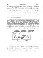
GPS, GALILEO and GLONASS, which employ one-way TOA measurements, the
RDSS requires two-way range measurements. That is, a system operations center
sends out a polling signal through one of the BeiDou satellites to a subset of users.
These users respond to this signal by transmitting a signal through at least two of
the system’s three geostationary satellites. The travel time is measured as the navigation signals loop from operations center to the satellite, to the receiver on the user
platform, and back around. With this time-lapse information, the known locations
of the two satellites, and an estimate of the user altitude, the user’s location can be
determined by the operations center. Once calculated, the operations center transmits the positioning information to the user. Since the operations center must calculate the positions for all subscribers to the system, BeiDou can also be used for fleet
management and communications [14, 15].
Current plans call for the BNTS to also provide integrity and wide area differential corrections via a satellite-based augmentation system (SBAS) service. (SBAS is
described in detail in Chapter 8.) At present, the RDSS capability is operational, and