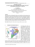
Tài liệu Water quality management for irrigation in the mekong river delta, Vietnam doc
Bạn đang xem bản rút gọn của tài liệu. Xem và tải ngay bản đầy đủ của tài liệu tại đây (359.89 KB, 8 trang )
WATER QUALITY MANAGEMENT FOR IRRIGATION
IN THE MEKONG RIVER DELTA, VIETNAM
L.A. TUAN
1
*
, G.C.L. WYSEURE
2
, L.H. VIET
1
& P.J. HAEST
2
1
College of Technology, CanTho University, Campus II, Street 3/2, CanTho City,
Vietnam;
2
Laboratory for Land and Water Management, K.U Leuven, Kasteelpark Arenberg 21,
B-3001 Heverlee, Belgium,
* E-mail:
--- oOo ---
ABSTRACT
The Mekong River Delta (MD), the most downstream part of the Mekong river, is
known as the biggest "rice bowl" of Vietnam. Currently, 2.4 million ha are used for
agriculture. During the rainy season part of the Delta is flooded. Along the 600 km-
coast, the sea tide strongly influences the water quality by sea water intrusion. In
addition, an area of 2-million ha is covered by acid sulfate soils. Also, the MD is very
densely populated with intense associated water pollution. The combination of the
hydrological regime, sea, soil-type and pollution poses original water quality
management problems for irrigation. Along the river and canals in the MD, the water
quality parameters are generally related to the use of fertilizers and pesticides in
agriculture, of nutrient-rich effluents from aquaculture and animal husbandry and of
wastewater from industrial plants and human populations. In the dry season and early
rainy period, the polluted water seriously impacts the agricultural cultivation and
domestic water supply.
Presently water-abstractions from the Mekong river are mainly used to irrigate the rice
and upland crops, curb salinity intrusion and leave acid sulfate soil layers with sufficient
wetness. These objectives are mainly agricultural. Current irrigation calendars, soil
maps and fluctuation of water quality parameters are discussed in this paper. The need
for a better water quality management and monitoring network in the river system are
presented. Not only irrigation control but also for industrial and population use is
considered. The existing discharge and water level recording stations should be the
preferred locations for water quality sampling. The classical parameters like pH,
salinity, total suspended solid (TSS), total Fe, Ca
2+
, Mg
2+
, Cl
-
, SO
4
2-
, Dissolved Oxygen
(DO), Biochemical Oxygen Demand (BOD
5
), Chemical Oxygen Demand (COD),
Allumium (NH
4
+
), Nitrate (NO
3
-
), Phosphorous (PO
4
3-
), heavy metal, coliform have to be
supplemented with bio-indicators like zooplankton and phytoplankton. Initial results
show that bio-indicators in the MD give a good indication of water quality.
Key words: irrigation, saline intrusion, acid sulfate soil, water quality management.
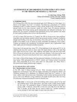
THE MEKONG RIVER DELTA IN VIETNAM IN GENERAL
The MD is located in the centre of the Southeast Asian region. It is really a large
wetland formed mostly by the alluvium deposition of the Mekong river (Figure 1). It lies
between latitudes 104°30' to 107°00' E and longitudes 8°30' to 11°00'N and covers an
area of 5.9 million hectares of which 3.9 million in Vietnam. The Delta in Vietnam is
bordered to the North by Cambodia, to the west by the Vam Co river, to the south by
the Eastern Sea and to the west by the Gulf of Thailand. The whole Delta is flat and
low laying except for some low mountains and hills in Chau Doc and Ha Tien.
The MD has great potentials for agricultural production with a population of 17 million
inhabitants living in 4 million hectares of land. The population of the MD has doubled
over the past 30 years and is estimated to grow by another 30 to 50 per cent by the
year 2025 (Mekong River Commission - MRC, 2004). Historically and practically the
2
population has settled densely on the along the river and canal banks, resulting a high
concentration of human pollutants along the water bodies in the Delta.
The long-term average annual rainfall in the MD varies from 1,400 - 2,200 mm (Figure
2). About 90% of total rain water falls from May to October (Figure 4). From September
to December each year, large areas in the South Western part of the Delta are
inundated by the Mekong river; especially around the Cambodian border (Figure 3).
Due to the effect of tropical monsoon rainfall characteristics, the flows at flooding time
are about 25 - 30 times the dry season flows which occur between March and April
(Öjendal, 2000). The Long Xuyen Quadrangle and the Plain of Reeds are a poorly
drained depression area with an inundation lasting up to 4 to 6 months. The total
inundated land of the MD in flooding season is about 1.2 to 1.9 million hectares. The
most heavy floods are caused by 3 simultaneous factors: by large discharges
originating from Southern Lao and the Great Lake in Cambodia, by long and heavy
rainfall in the MD, and by the high tides. Although such floods may cause loss of
human life and of properties they also have beneficial consequences: deposition of
nutrients, leaching out the field pollutants and toxics as aluminum and iron, removal of
acidity from acid sulfate soils, desalinization of water, killing insects and supply of fish.
In the dry season, lasting 7 months, the discharge from the Mekong river decreases
and leads to more intense seawater intrusion. As a consequence many coastal areas
suffer serious shortages of fresh water supply.
There are more or less 2.1 million hectares of the MD (Figure 5) affected by salinity
from sea water intrusion in open mouths and estuaries. Seawater intrusion in the river
branches is very complicated. The main factors are river discharge, local rainfall and
runoff, the amplitude of tides in the East Sea and the Gulf of Thailand, the slope of the
river bed, the wind velocity and direction and the depth of the estuary. Salt water
intrudes the inland from the Hau and Tien rivers' mouths and Ca Mau peninsula's
estuaries, strongly from February to April.
About 47% of the MD is occupied by acid sulfate soils (more than 1.6 million hectares):
mainly in the Long Xuyen - Ha Tien quadrangle, the Plain of Reeds, the West Hau river
Fig.1: The Mekong River Basin and Land forms of the MD in Vietnam
3
and in a part of Ca Mau peninsula. This soil is very sensitive to the fluctuations in the
river discharge and groundwater table. From March and April, the subsurface water
level lowers by approximately 1.0 meter and therefore deep cracks in the soils result in
oxidization of the pyrite horizon into acid sulfate.
Fig.2 (left): Rainfall distribution in the MD (Yamashita, 2003)
Fig.3 (right): Flooding depth and duration in the MD (Yamashita, 2003)
Fig.4 : Monthly mean discharge of the Mekong river to Vietnam
IRRIGATION SYSTEMS IN THE MEKONG RIVER DELTA
The socio-economical development in the Delta is constrained by its water resources
regime. Agricultural and fishery production has a very high water demand and is a
major export earning for Vietnam. The Delta contributes for 27% of the total GDP of
Vietnam (Minh, 2003). Approximately 2 million tons of rice, produced in the MD, are
yearly exported from Vietnam. Currently, 2.4 million hectares of the MD is used for
Month
Monthly Mean Discharge
in Tan Chau (Tien River) and Chau Doc (Hau River)
Jan
Feb
Mar
Apr May Jun Jul Aug Sep Oct Nov Dec
Discharge (m
3
/s)
0
5,000
10,000
15,000
20,000
25,000
Tan Chau
Chau Doc
459
2041
5733
19,296
4
agriculture and aquaculture highly depending on water from the river and canal
systems. The agricultural production currently consumes 85 - 90% of the total water
supply.
Fig. 5 (left): Status of saline intrusion in the MD (Yamashita, 2003)
Fig.6 (right): Density of salinity in surface water (Yamashita, 2003)
Rice cultivation occupies almost 90% of the agricultural land. To produce one kilogram
of rice requires 3,000 - 5,000 liters of water, depending on the rice variety and type of
irrigation used (MRC, 2004). At the same time, aquaculture areas are increasing with
an annual rate of 4.1% (General Statistical Office, 2000) due to their higher potential for
export earnings as compared to rice. The rice cultivation areas have increased yearly
by more than 100,000 ha during the period 1995 -1999. This has lead to higher water
demands for irrigation and therefore only a fraction of the rice cultivation lands can be
irrigated in the dry season. Water use in the Mekong delta in 1995 was more than 210
million m
3
as compared to 534 million m
3
used by the whole Vietnam (Su, 1996).
Between 1976 – 1990 due to the introduction of high-yielding rice varieties and
improved techniques the total rice production doubled while the rice areas only
increased by approximately 20%. Even recently from 1996 to 2003, the yearly rice yield
of the Delta of 12.8 million has increased to 17.5 million ton. This accounts for 50%
national food production in Vietnam and plays an important role in the national food
security.
Depending on the water supply capacity and land use pattern, there are three major
rice cropping systems in the MD (Figure 7):
(i) the single rice crop as Mua crop (rainfed rice);
(ii) double rice crop as Dong Xuan crop (Winter-Spring) and He Thu crop
(Summer - Autumn) or He Thu crop and Mua crop; and
(iii) triple rice crop as Dong Xuan crop (Winter-Spring) and He Thu crop
(Summer - Autumn) and Mua crop.
Many water resources projects have been established and implemented during last 3
decades in order to keep track of the demand and to ensure food security and
improvement of the living standards for people of the Vietnam Government.
The aims of these water works are:
• to extend existing irrigation systems, mainly in the in the middle and upper delta
where double and triple rice cultivation each year is dependent on water supply
during the dry season;
• to prevent salinity intrusion by sluices, water gate, small dams and dikes
systems in the coastal areas. These water control works can be closed in the
high tides periods for flood protection;
5
• to reclaim the acid surface soil areas by soil washing and acid-neutralization
capability of the flood plus rain water and by keeping water table higher than
potential acid horizon;
• to improve flood water control and drainage by dividing flooding water to the
western sides and other local depressed areas;
• to extend rural water supply and sanitation, special needs for the remote areas
and the saltwater/acid water- affected zone;
• to strength water resources management capacity by training and equipping to
the water staff;
• to install water environmental monitoring systems by establishing water
sampling and pollution warning stations along the industrial zones, cities and
rivers/canals.
Fig. 7: Cropping calendar, monthly rainfall and water demands in the MD
Note: VH: very high; H: High; M: Medium; L: Low
More than 3,300 billion VND (nearly 210 million USD) was invested in 105 irrigation
projects in the Mekong delta in the 1996-2003 period, of which 60 out of 105 projects
were completed (Vietnam News Agency, 2003). The main components of these
projects are to construct water control sluices, small and medium scale pumping
stations, flood control embankments and small dams, together with the necessary
primary, secondary and tertiary canal systems connecting to the field. Until now, there
are over 7,000 km length of main channels, 4,000 km on-farm systems, more than
20,000 km of protection dikes to prevent early flood (Ministry of Agriculture and Rural
Development - MARD, 2003). These canal systems are not only used for irrigation,
drainage but also for water supply, fishery, local transport by boat. As general
guideline, the systems are designed for an irrigation supply of 1.1 to 1.2 liter per
second per hectare (l/s.ha) and for a drainage intensity of 3,3 to 3.5 l/s.ha. They are
hydraulically operated by mixing flows from upstream rivers branches in the MD and
tides from the East Sea and the Gulf of Thailand. In the fields, the farmers control water
level by using small earth-dams, weirs or low-lift pumps according to crop needs.
SEASONAL WATER RELATED PROBLEMS IN THE MEKONG DELTA
As one of the specific natural characteristics of the tropical monsoon climate regions,
there are only two seasons in the Mekong Delta: dry season and rainy season.
Dry season: The monthly mean discharge in the Mekong river is lower than 2,500
m
3
/s, during January to April, together with the lower groundwater table lead to a
serious shortage of fresh water for rice cultivation and domestic drinking water. Salinity
intrusion areas expand throughout the MD. However, saltwater intrusion also has
positive impacts (Miller, 2000). Many coastal farmers apply a rice-shrimp rotation and
need saltwater to raise native shrimp. The lower water level in the dry season is also