Tài liệu People''''s adaptability to floods in the Mekong river delta pptx
Bạn đang xem bản rút gọn của tài liệu. Xem và tải ngay bản đầy đủ của tài liệu tại đây (211.13 KB, 2 trang )
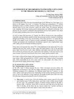
Fig. 1: The Mekong basin
Fig. 2: MD flooding map in 2000
A DISCUSSION PROPOSAL ON
PEOPLE’S ADAPTABILITY TO FLOODS
IN THE MEKONG RIVER DELTA
Le Anh Tuan
1
1
Department of Environment and Water Resources Engineering
College of Technology, CanTho University, CanTho City, Vietnam
E-mail:
oOo
I. INTRODUCTION
The Mekong river is ranked as the tenth one in the list of the largest rivers in the world
and is longest river in southeastern Asia. From its source in Tibet, the river flows to the South
China Sea through Yunnan, China, forms the border partly between Burma and Laos and most of
the border between Laos and Thailand, then the main stream goes into Cambodia and finally it
flows across southern Vietnam to the sea (figure 1). The river has 4,200 km long and carries more
than 450,000 million m
3
of runoff water yearly to sea. About 80 percent of annual flow volume
enters the low lying parts of the basin in Vietnam as the flood season from June to November.
The river network of the Mekong is rather complicated, especially from Cambodia to Vietnam. At
Phnom Penh, the river meets the Tongle Sap river, then splits into Tien river and Hau river before
entering the border of Vietnam and continues to branch into 9
tributaries as the river estuaries.
The Mekong River Delta (MD) in Vietnam is considered as a
biggest agriculture and aquaculture production region of the
nation. The total natural area of the MD amounts to 3.90 million
ha, of which 2.4 million ha of land currently is used for
agriculture. The Delta’s total population is estimated at nearly
18 million of Vietnam inhabitants, they made active
contributions more than 50 percent of staple food and 60 percent
of fish-shrimp production of Vietnam. Historically, the
population has settled densely along the rivers’ and canals’
levees. Almost all the people’s activities and infrastructure are
depended highly on the water and land resources. The MD
farmers are very adaptive to the changes of water regimes for
building up many sustainable ways for their own life.
II. FLOOD HISTORY AND DAMAGE
Due to locate in the most downstream part of the
Mekong river to the sea, the MD accepts yearly all the
water flood volume of the basin. About 1.2 to 1.9 million
ha of land, mainly in the North parts of the MD such as the
LongXuyen quadrangle and the Plain of Reeds,
affected
by annual flooding by overflow water from the river and
overland flood water from Cambodia across the Vietnam
border (figure 2)
. Flood season in the Delta starts from
July, increases gradually on August-September, peaks on
October and goes down on November. The average
duration of flooding in the MD is more than 3 months. In
the 20
th
century, the Delta had more than 11 big floods, as
the peak water levels in TanChau (Tien river) and ChauDoc
(Hau river) were counted equal or higher then 4.50 m MSL, occurring in the years 1904, 1923,
1937, 1961, 1966, 1978, 1984, 1991, 1994, 1996, 2000.
The flood in year 1994 to the MD killed
nearly 500 people and damaged to property more than 210 million US dollars. In October 2000,
the MD faced one of largest and most damaged flood in 70 years: over 300,000 households were
reportedly submerged with over 2,900 destroyed, 1.3 million people were affected. An estimated,
more than 500 million US dollars of material facilities was lost.
III. NATIONAL POLICES AND PEOPLE’S BEHAVIOUR WITH FLOOD
Last two decades, as a part of Vietnam Government’s rural development policies to
provide water mainly for agricultural productivity, protect against flood and control salinity
intrusion, many large-and-medium-scale hydraulic works such as pumping stations, irrigation and
drainage canal systems, crop protection dikes and dams have been built in the Mekong Delta.
Almost these water works were investigated by the national budget or the contribution of the
local people and government according to the motto: “Both the Government and People do
together”. Almost of these water works play significant role in providing benefit to local farmers
but they have also brought other damages to other neighboring areas as negative effects.
However, up to now, almost there is no an overall long-term evaluation on the impacts of
hydraulic works to the sustainable development of the Delta.
In recent years, the Delta farmers are generally not to consider annual floods as a natural disaster
or an “enemy” of their production, even in high flooding if they are not so unusual. Many years
before, they did not say the word “flood season” but used “raising water season”. In fact, floods
bring new organic matter from upstream and deposit alluvium to the fields of the Delta. Flooding
water eliminates a great part of the salinity in the soil in the coastal areas and flushes toxicity
released from acid sulfate soil. Also, floods kill the insets and rats population. Otherwise, flood
brings natural fishes, brings plankton which is food for fishes in cases and pools. In some
questionnaire survey and interviews have been implemented in AnGiang, DongThap and
LongAn, almost the farmers said that “Living with flood” or “Shaking hands with flood” as the
best way for the Mekong Delta sustainable development.
IV. DISCUSSION
In order to approach this flooding problem in many of its aspects, both negative and
positive impacts, an overall consideration is necessary for reduce the risk and damage from this
natural phenomenon. Some below information are needed and a few researches should be done:
• Analyze the flood frequency occurred in the Mekong river: find out the general rules of
the seasonal flows, forecast the relation between the warm atmosphere and the storms in
the tropical monsoon Asia.
• Survey and forecast the effects of the dams and irrigation systems in upstream to the low
parts of the basin.
• Estimate the role of floods in the people’s lives; notice the effects to the women and
children in the flooded areas.
• Assess the environmental impacts of the “anti-flood” works in the MD.
• Evaluate the role of mass information media to the people.
• Identify possibilities and constraints in government’s policies concerning the flood
preparedness and other natural disasters management.
• Exchange the experiences on flood risk reduction in other regions and countries.