Wireless Sensor Networks Part 7 potx
Bạn đang xem bản rút gọn của tài liệu. Xem và tải ngay bản đầy đủ của tài liệu tại đây (1.27 MB, 25 trang )
Data Aggregation Tree Construction: Algorithms and Challenges 143
so the information associated with an event is sensed by more than one sensor node. The
nodes transmit the redundant information to the sink (Liang & Liu, 2006).
Transmission of these redundant data wastes energy. As energy resources are the most
important limitation of WSNs and data transmission is the most costly function in the
network. This leads to decrease in the node’s power, quickly (Akyildiz et al, 2002). After
some rounds, network nodes energy is finished and this leads to cases in which the network
can not work anymore. Regarding the above mentioned points, in order to increase the
network’s lifetime, the number of transmitted data packets should be minimized (Akyildiz
et al, 2002; Eskandari et al a, 2008).
As described in (Upadhyayula & Gupta, 2006), a round is defined as the collection of one
data unit from every node in the network and delivering the resulting aggregated data to
the sink node. And, also based on this work, the lifetime of a tree is defined as the number of
rounds that can be performed before the failure of certain percentage of total nodes.
Based on energy model described in (Kamimura et al, 2004), a sensor node consumes E
elec
(J/bit) in transmitter or receiver circuitry and Eamp (J/bit/m
2
) in transmitter amplifier to
achieve an acceptable signal noise ratio. A sensor node expends energy ETij (k) or ERi(k) in
transmitting or receiving a k-bit packet to or from distance distij, given by the following
equations:
ijampelecij
distkEkEkET ***)(
(1)
kEkER
eleci
*)(
(2)
The exponent λ heavily depends on the communication medium (Upadhyayula & Gupta,
2006). As described in (Younis & Fahmy, 2004) if aggregation function is simple, the energy
consumption for data aggregation will be negligible.
1.1 Data Aggregation
A number of mechanisms called aggregation algorithms are suggested in order to omit the
redundant data. Aggregation algorithms, after receiving data from several sensors, process
data and omit the redundancy and send the result of aggregation to the sink (Liang & Liu,
2006). Due to the reduction in data volume, these algorithms decrease the energy
consumption (Lee & Wong a, 2005).
Therefore the networks which perform aggregation have more life time (Eskandari et al a,
2008; Lee & Wong a, 2005) and draw more attention (Eskandari et al a, 2008; Lee & Wong a,
2005; Lee & Wong b, 2005). In addition to mentioned improvements, aggregation decreases
collision and retransmission delay (Zhu et al, 2006).
Data aggregation is performed during routing in wireless sensor networks. Finding the
route from several nodes to the sink in a way that maximizes the shared path and
redundancy removing is one of the main objectives in these protocols (Liang & Liu, 2006).
In aggregation algorithms, we must construct aggregation spanning tree (Lee & Wong a,
2005). The spanning tree is a tree which contains all network nodes and doesn’t have any
loop.
Aggregation mechanism works as follow: each node senses data from the environment and
receives other node’s data, then aggregates these data, based on the aggregation function
and transmits the aggregation result to the sink.
2. Aggregation Tree Construction
As a result of energy saving of data aggregation, different aggregation algorithms have been
presented. In this section, we review them briefly and compare their efficiency, and then we
introduce a new algorithm, describe it and evaluate its efficiency. Finally, we consider a new
challenge, i.e. tree construction cost.
2.1 Recent Works
In (Krishnamachari et al, 2002), the authors investigate the computational complexity of
optimal data aggregation in sensor networks and show that it is generally NP-hard; they
present some suboptimal data aggregation tree generation heuristics, Center at Nearest
Source (CNS), Shortest Paths Tree (SPT) and Greedy Incremental Tree (GIT) and show the
existence of polynomial special cases.
As presented in (Zhang & Cao, 2004), DCTC algorithm dynamically constructs the
aggregation tree for mobile target tracking. In the presented algorithm depending on the
target location, a subset of nodes participates in tree construction.
In (Upadhyayula et al, 2003), the sink saves the entire network state and then by
considering link cost, in centralized form, constructs the tree with minimum cost. In cluster
algorithm (Younis & Fahmy, 2004), after partitioning the network into clusters, cluster’s
members construct aggregation tree and transmit data to cluster head. After aggregation,
cluster heads transmit aggregated data to the sink in one hop or multihop manner (Chen et
al, 2005).
Espan (Lee & Wong a, 2005) is an energy-aware spanning tree algorithm that constructs the
aggregation tree to aggregate the data. In Espan, the source node which has the highest
residual energy is chosen as the root and other nodes choose their corresponding parent
node among their neighbors based on distance to the root and residual energy. Each node
selects the closest neighbors to root as its parent. If there are multiple neighbors with equal
distance, the node which has the most remaining energy is selected as parent.
As Espan protocol considers distance as main parameter and remaining energy as second,
one of the most important problems of Espan is that the nodes with the least distance to root
maybe selected as parent by many nodes. So these nodes consume their energy quickly and
then they will fail sooner than other network nodes, so the network cannot cover region
completely.
In LPT (Lee & Wong b, 2005) after selecting the node with most energy as root, each node
selects neighbors with the most energy as parent and its parent forwards its data to the sink.
In the mentioned algorithm, when a node in the tree fails, the tree will be reconstructed. LPT
aims to prolong the lifetime of the sources which transmit data reports periodically. But in
LPT, the parents may have higher distance to root and this cause more energy consumption.
LPT does not consider the distance parameter in parent selection.
We have presented an energy efficient algorithm, which constructs the aggregation tree in
(Eskandari et al a, 2008). To prevent failing of nodes and to increase the network lifetime,
the algorithm considers both the remaining energy and the distance parameters. Each node
selects a node which has the most energy within neighbors as its parent. Furthermore, the
distance from this parent to the root must be reasonable. To balance the energy and distance
parameters, the algorithm uses path’s energy and length parameters.
Wireless Sensor Networks 144
2.2 An Efficient Aggregation Tree Construction Algorithm
In this section, we present an Energy Efficient Spanning tree (EEspan) algorithm which is a
new energy efficient algorithm for wireless sensor networks. The current work is a modified
version of our former published papers (Eskandari et al a, 2008; Eskandari et al b, 2008).
Unlike the algorithms given in (Lee & Wong a, 2005; Lee & Wong b, 2005) which use only
one of the distance and energy parameters as the main parameter, to decrease the number of
failed nodes and to increase the network lifetime, this algorithm considers both remaining
energy and distance parameters.
To control the energy and distance parameters, the algorithm uses path’s energy and path’s
length parameters. Using this strategy, a node with low remaining energy can be alive more
than that of Espan protocol. This increases the lifetime of the network and supports better
coverage. Also, unlike the LPT algorithm, the presented algorithm prevents selecting a
parent with high remaining energy, and far distance to the root.
In fact, the presented algorithm might select a node with higher energy but farther from root
as its parent. If the selected neighbor with highest energy is in a distance farther than a
threshold, the presented algorithm selects the less energy path. In addition, to provide
fairness in energy consumption, the algorithm considers a third parameter which is the
maximum number of children. In the presented algorithm, the nodes have a predetermined
maximum number of children. Based on (Upadhyayula & Gupta, 2006), if the nodes have
the same number of children, we can conclude that the nodes will be prepared to transmit
data at the same time and their parent will have to be awake for a shorter duration to collect
data from all its children.
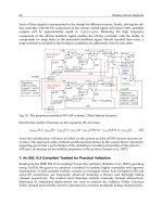
An example which helps us to understand the details of the presented algorithm is given in
Figure 1.
Fig. 1. The spanning trees of different algorithms a) connectivity graph, b) Espan’s tree, c)
LPT’s tree, d) EEspan’s tree
In this example, a connectivity graph with 10 different sensor nodes is used. The Espan, LPT
and EEspan spanning trees are shown in figure 1. The remaining energy of nodes 1, 2, 3, 4, 5,
6, 7, 8, 9 and 10 are equal to 10J, 5J, 7J, 2J, 5J, 6J, 6J, 6J, 6J and 3J, respectively. Suppose that
node 10 wants to select its parent.
Using Espan algorithm, node 4 which has the minimum distance to the root will be selected,
while in the presented algorithm, node 9 which has more average path’s energy is selected
as the parent of node 10. The selected parent by Espan algorithm has low energy and fails
quickly. As shown in Figure 1(c), LPT’s tree has longer path length which causes more
energy consumption.
The algorithm is a distributed algorithm which does not need to save global information
about the entire network. This makes the presented algorithm more scalable. Furthermore,
in the algorithm, routing is done in a multihop manner.
To verify the energy efficiency of the algorithm, here, we evaluate performance of the
algorithm. Figure 2 shows the average path length of the three algorithms. At the beginning
rounds, the Espan algorithm has lower energy consumption. This is because in this
algorithm, nodes transmit data via shortest paths, but by ruining the low power nodes in
these paths, data must be transmitted via other paths which may be longer. Since LPT
algorithm selects paths by considering only the energy parameter, nodes transmit their data
via longer paths which make higher energy consumption.
Fig. 2. The average path length of three algorithms
Data Aggregation Tree Construction: Algorithms and Challenges 145
2.2 An Efficient Aggregation Tree Construction Algorithm
In this section, we present an Energy Efficient Spanning tree (EEspan) algorithm which is a
new energy efficient algorithm for wireless sensor networks. The current work is a modified
version of our former published papers (Eskandari et al a, 2008; Eskandari et al b, 2008).
Unlike the algorithms given in (Lee & Wong a, 2005; Lee & Wong b, 2005) which use only
one of the distance and energy parameters as the main parameter, to decrease the number of
failed nodes and to increase the network lifetime, this algorithm considers both remaining
energy and distance parameters.
To control the energy and distance parameters, the algorithm uses path’s energy and path’s
length parameters. Using this strategy, a node with low remaining energy can be alive more
than that of Espan protocol. This increases the lifetime of the network and supports better
coverage. Also, unlike the LPT algorithm, the presented algorithm prevents selecting a
parent with high remaining energy, and far distance to the root.
In fact, the presented algorithm might select a node with higher energy but farther from root
as its parent. If the selected neighbor with highest energy is in a distance farther than a
threshold, the presented algorithm selects the less energy path. In addition, to provide
fairness in energy consumption, the algorithm considers a third parameter which is the
maximum number of children. In the presented algorithm, the nodes have a predetermined
maximum number of children. Based on (Upadhyayula & Gupta, 2006), if the nodes have
the same number of children, we can conclude that the nodes will be prepared to transmit
data at the same time and their parent will have to be awake for a shorter duration to collect
data from all its children.
An example which helps us to understand the details of the presented algorithm is given in
Figure 1.
Fig. 1. The spanning trees of different algorithms a) connectivity graph, b) Espan’s tree, c)
LPT’s tree, d) EEspan’s tree
In this example, a connectivity graph with 10 different sensor nodes is used. The Espan, LPT
and EEspan spanning trees are shown in figure 1. The remaining energy of nodes 1, 2, 3, 4, 5,
6, 7, 8, 9 and 10 are equal to 10J, 5J, 7J, 2J, 5J, 6J, 6J, 6J, 6J and 3J, respectively. Suppose that
node 10 wants to select its parent.
Using Espan algorithm, node 4 which has the minimum distance to the root will be selected,
while in the presented algorithm, node 9 which has more average path’s energy is selected
as the parent of node 10. The selected parent by Espan algorithm has low energy and fails
quickly. As shown in Figure 1(c), LPT’s tree has longer path length which causes more
energy consumption.
The algorithm is a distributed algorithm which does not need to save global information
about the entire network. This makes the presented algorithm more scalable. Furthermore,
in the algorithm, routing is done in a multihop manner.
To verify the energy efficiency of the algorithm, here, we evaluate performance of the
algorithm. Figure 2 shows the average path length of the three algorithms. At the beginning
rounds, the Espan algorithm has lower energy consumption. This is because in this
algorithm, nodes transmit data via shortest paths, but by ruining the low power nodes in
these paths, data must be transmitted via other paths which may be longer. Since LPT
algorithm selects paths by considering only the energy parameter, nodes transmit their data
via longer paths which make higher energy consumption.
Fig. 2. The average path length of three algorithms
Wireless Sensor Networks 146
Fig. 3. Number of alive nodes at N=500
Fig. 4. Number of alive nodes at N=700
In Figures 3, 4, for different values of N, N = 500, and 700 nodes, the average number of
alive nodes is plotted versus runtime. As the EEspan selects the nodes with high remaining
energy, the nodes with low energy remain longer time in the network. Therefore the number
of alive nodes is more than that of Espan algorithm. Furthermore, the LPT algorithm
transmits data via the longer paths that leads to consume more energy and the failure of
more nodes. More alive nodes can sense environment better, that means the network nodes
have better coverage.
In Figure 5, for the three algorithms, the average lifetime is plotted versus the number of
nodes. The main objective of all the algorithms is to achieve high energy efficiency. In
addition to reducing the energy consumption, balancing energy consumption in nodes is
important, too. In Espan algorithm, nodes transmit data via the smallest paths, but this leads
the low power nodes in these paths to fail quickly and so the network’s lifetime is
decreased. To balance energy consumption in the network, the EEspan algorithm operates
in an energy aware and transmit data via paths with more energy. Note that EEspan
algorithm considers the path length to find the best tree.
Fig. 5. Average lifetime comparison
2.3 Aggregation Tree Construction Cost
Since the status of the network is dynamic, like routing algorithms, aggregation algorithms
should also be aware of the network topology and based on these information and queries
which are propagated by root, network nodes select aggregation function and aggregate the
data, and then forward the aggregated data to sink. And, also they should construct the
aggregation tree periodically. To construct an aggregation tree, at the beginning of each
period, routing packets are flooded into the entire network to inform all nodes. After this
step, each node selects the best path towards the sink node and transmits data via the
selected path until the next period. When a timer is expired or some nodes fail in the
network, the new aggregation tree must be constructed (Lee & Wong a, 2005; Lee & Wong b,
2005). Since the node’s energy is limited, transmitting and receiving this volume of routing
information is not a good solution to construct an aggregation tree. This overhead causes a
lot of energy consumption. So, some nodes run out of energy quickly and fail. This causes
the network to be disconnected.
Data Aggregation Tree Construction: Algorithms and Challenges 147
Fig. 3. Number of alive nodes at N=500
Fig. 4. Number of alive nodes at N=700
In Figures 3, 4, for different values of N, N = 500, and 700 nodes, the average number of
alive nodes is plotted versus runtime. As the EEspan selects the nodes with high remaining
energy, the nodes with low energy remain longer time in the network. Therefore the number
of alive nodes is more than that of Espan algorithm. Furthermore, the LPT algorithm
transmits data via the longer paths that leads to consume more energy and the failure of
more nodes. More alive nodes can sense environment better, that means the network nodes
have better coverage.
In Figure 5, for the three algorithms, the average lifetime is plotted versus the number of
nodes. The main objective of all the algorithms is to achieve high energy efficiency. In
addition to reducing the energy consumption, balancing energy consumption in nodes is
important, too. In Espan algorithm, nodes transmit data via the smallest paths, but this leads
the low power nodes in these paths to fail quickly and so the network’s lifetime is
decreased. To balance energy consumption in the network, the EEspan algorithm operates
in an energy aware and transmit data via paths with more energy. Note that EEspan
algorithm considers the path length to find the best tree.
Fig. 5. Average lifetime comparison
2.3 Aggregation Tree Construction Cost
Since the status of the network is dynamic, like routing algorithms, aggregation algorithms
should also be aware of the network topology and based on these information and queries
which are propagated by root, network nodes select aggregation function and aggregate the
data, and then forward the aggregated data to sink. And, also they should construct the
aggregation tree periodically. To construct an aggregation tree, at the beginning of each
period, routing packets are flooded into the entire network to inform all nodes. After this
step, each node selects the best path towards the sink node and transmits data via the
selected path until the next period. When a timer is expired or some nodes fail in the
network, the new aggregation tree must be constructed (Lee & Wong a, 2005; Lee & Wong b,
2005). Since the node’s energy is limited, transmitting and receiving this volume of routing
information is not a good solution to construct an aggregation tree. This overhead causes a
lot of energy consumption. So, some nodes run out of energy quickly and fail. This causes
the network to be disconnected.
Wireless Sensor Networks 148
3. Reconfiguration
To solve the mentioned problems, in this section we introduce reconfiguration property; if a
node in the aggregation tree fails, and a part of the tree is disconnected, only this part of tree
starts to reconstruct locally, so it is not necessary to flood routing packets into the entire
network. To do this, each node uses the environment feedbacks, and updates its information
on its neighbors. In this section we introduce an automata-based algorithm to reconstruct
spanning tree, the current work is published in [Eskandari et al b, 2008; Eskandari et al c,
2009).
3.1 Recent Works
Cluster based algorithms (Younis & Fahmy, 2004) needs only local information to construct
the aggregation tree; therefore they transmit fewer packets to construct the aggregation tree.
In (Radivojac et al, 2003), the presented algorithm uses machine learning to transmit the
sensed data to the sink. Learning algorithm is executed in the sink and its result is
propagated throughout the network. In (Beyens et al, 2005) Q-leaner is used to construct
aggregation tree to maximize aggregation ratio.
In (Esnaashari & Meybodi, 2007), an algorithm to construct the automata-based aggregation
tree, is presented. In this algorithm, in which each node is equipped with an automaton, the
automaton selects a path for transmitting data via the path whose aggregation ratio is
maximized. In (Ankit et al, 2006), the algorithm considers an automaton for each node,
which selects a path to transmit data to the sink in accordance with network conditions.
3.2 An automata Based Aggregation Tree Reconstruction Algorithm
Learning automata is an abstract model which has a finite set of actions as its input. Each
member of the input set has a selection probability parameter. The automata select an input with
highest selection probability as their output. Then the environment evaluates the selected action
and responses to the automata. Automata use the response for learning process.
Learning process is as follows: if the environment response is unfavorable based on network
parameter, the automata penalize the selected input by decreasing its selection probability and
increasing selection probability of the other members of the input set. But if the environment
response is favorable, the automata reward the selected input by increasing its selection
probability and decreasing selection probability of the other members of the input set. The
rewarding process increases selection probability of the awarded input for the next step. As
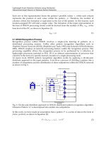
shown in figure 6, an automaton is learned based on the feedback of the environment.
Fig. 6. learning automata
In automata-based algorithms (Ankit et al, 2006; Esnaashari & Meybodi, 2007), at the
beginning, routing packets are flooded into the entire network. Each node considers each
neighbor as entry in its routing table and then calculates the selection probability of each
entry based on the algorithm’s parameters, energy or distance and etc., and then each node
selects the neighbor with highest selection probability as its parent and sends its data via
this parent to the root.
In (Esnaashari & Meybodi, 2007) after receiving data, the root sends acknowledgment to the
sender node; this acknowledgment has some information for automata. Based on
acknowledgment information, automata penalize or reward the path’s nodes, on the way
that if the selected path was optimal based on the network parameters, the selection
probability is increased for the next step, but if the selected path was not optimal, the
selection probability is decreased for the next step. This process is called automata learning.
In the next steps, each node selects a new parent based on the updated selection probability
of the nodes in the network and this process is repeated till the end of the network’s lifetime.
By using this learning property of automata, the algorithm prevents flooding the routing
packets periodically, at the same time, by using ack information, nodes become aware of
changes in network topology and paths are updated.
The presented algorithm in this section works as follows: at the beginning, routing packets
are flooded into the network. Each neighbor, after receiving these packets, considers the
sender as a new entry in its routing table.
This sending/receiving is performed in the entire network, so each node maintains
neighbors information in its routing table. Then the routing table entries are considered as
input set of automata and the automata calculate the selection probability of each entry as
follow:
j
j
i
cedis
energy
CprobSel
tan
*
(3)
In equation 3, Ci is a constant which is calculated by node and is dependent on the sum of
energy and distances to the root of entries in routing table of node i.
Each node selects neighbor with highest selection probability as its parent, nodes in the
network sense data and aggregate them with collected data from their child, then send the
result of aggregation to their parents. Their parents forward data to the sink by repeating
this process.
In order to update the automata, each node must collect some information from the
network. By using this information, an automaton becomes aware of the network changing.
In (Ankit et al, 2006) to be aware of the network state, each node after receiving data sends
feedback or acknowledgment message to the sender of the data and as mentioned before,
this message has some information. By using these feedbacks, automata penalize or reward
the selected parent, but sending these acknowledgments have a lot of overhead. In
(Esnaashari & Meybodi, 2007) to decrease this overhead, acknowledgment is sent after some
data transmissions.
But, transmitting these additional data leads to waste of energy because parent’s energy
becomes less than other nodes in the neighborhood after some rounds. So, we can improve
algorithm performance by working as follows: if a node in the aggregation tree fails or the
node’s energy is lower than a pre determined threshold, then the node’s children select a
Data Aggregation Tree Construction: Algorithms and Challenges 149
3. Reconfiguration
To solve the mentioned problems, in this section we introduce reconfiguration property; if a
node in the aggregation tree fails, and a part of the tree is disconnected, only this part of tree
starts to reconstruct locally, so it is not necessary to flood routing packets into the entire
network. To do this, each node uses the environment feedbacks, and updates its information
on its neighbors. In this section we introduce an automata-based algorithm to reconstruct
spanning tree, the current work is published in [Eskandari et al b, 2008; Eskandari et al c,
2009).
3.1 Recent Works
Cluster based algorithms (Younis & Fahmy, 2004) needs only local information to construct
the aggregation tree; therefore they transmit fewer packets to construct the aggregation tree.
In (Radivojac et al, 2003), the presented algorithm uses machine learning to transmit the
sensed data to the sink. Learning algorithm is executed in the sink and its result is
propagated throughout the network. In (Beyens et al, 2005) Q-leaner is used to construct
aggregation tree to maximize aggregation ratio.
In (Esnaashari & Meybodi, 2007), an algorithm to construct the automata-based aggregation
tree, is presented. In this algorithm, in which each node is equipped with an automaton, the
automaton selects a path for transmitting data via the path whose aggregation ratio is
maximized. In (Ankit et al, 2006), the algorithm considers an automaton for each node,
which selects a path to transmit data to the sink in accordance with network conditions.
3.2 An automata Based Aggregation Tree Reconstruction Algorithm
Learning automata is an abstract model which has a finite set of actions as its input. Each
member of the input set has a selection probability parameter. The automata select an input with
highest selection probability as their output. Then the environment evaluates the selected action
and responses to the automata. Automata use the response for learning process.
Learning process is as follows: if the environment response is unfavorable based on network
parameter, the automata penalize the selected input by decreasing its selection probability and
increasing selection probability of the other members of the input set. But if the environment
response is favorable, the automata reward the selected input by increasing its selection
probability and decreasing selection probability of the other members of the input set. The
rewarding process increases selection probability of the awarded input for the next step. As
shown in figure 6, an automaton is learned based on the feedback of the environment.
Fig. 6. learning automata
In automata-based algorithms (Ankit et al, 2006; Esnaashari & Meybodi, 2007), at the
beginning, routing packets are flooded into the entire network. Each node considers each
neighbor as entry in its routing table and then calculates the selection probability of each
entry based on the algorithm’s parameters, energy or distance and etc., and then each node
selects the neighbor with highest selection probability as its parent and sends its data via
this parent to the root.
In (Esnaashari & Meybodi, 2007) after receiving data, the root sends acknowledgment to the
sender node; this acknowledgment has some information for automata. Based on
acknowledgment information, automata penalize or reward the path’s nodes, on the way
that if the selected path was optimal based on the network parameters, the selection
probability is increased for the next step, but if the selected path was not optimal, the
selection probability is decreased for the next step. This process is called automata learning.
In the next steps, each node selects a new parent based on the updated selection probability
of the nodes in the network and this process is repeated till the end of the network’s lifetime.
By using this learning property of automata, the algorithm prevents flooding the routing
packets periodically, at the same time, by using ack information, nodes become aware of
changes in network topology and paths are updated.
The presented algorithm in this section works as follows: at the beginning, routing packets
are flooded into the network. Each neighbor, after receiving these packets, considers the
sender as a new entry in its routing table.
This sending/receiving is performed in the entire network, so each node maintains
neighbors information in its routing table. Then the routing table entries are considered as
input set of automata and the automata calculate the selection probability of each entry as
follow:
j
j
i
cedis
energy
CprobSel
tan
*
(3)
In equation 3, Ci is a constant which is calculated by node and is dependent on the sum of
energy and distances to the root of entries in routing table of node i.
Each node selects neighbor with highest selection probability as its parent, nodes in the
network sense data and aggregate them with collected data from their child, then send the
result of aggregation to their parents. Their parents forward data to the sink by repeating
this process.
In order to update the automata, each node must collect some information from the
network. By using this information, an automaton becomes aware of the network changing.
In (Ankit et al, 2006) to be aware of the network state, each node after receiving data sends
feedback or acknowledgment message to the sender of the data and as mentioned before,
this message has some information. By using these feedbacks, automata penalize or reward
the selected parent, but sending these acknowledgments have a lot of overhead. In
(Esnaashari & Meybodi, 2007) to decrease this overhead, acknowledgment is sent after some
data transmissions.
But, transmitting these additional data leads to waste of energy because parent’s energy
becomes less than other nodes in the neighborhood after some rounds. So, we can improve
algorithm performance by working as follows: if a node in the aggregation tree fails or the
node’s energy is lower than a pre determined threshold, then the node’s children select a
Wireless Sensor Networks 150
new parent from the nodes in their neighborhoods. Then, it is not necessary to reconstruct
the aggregation tree globally and periodically.
By using this strategy the tree is reconstructed when it is needed, and reconstruction packet
broadcasts locally. This leads to reduction in data transmission in the network and power
saving.
Reconstruction property is an important section in the tree construction algorithm that is
noted rarely. In this work, we try to achieve two main goals:
Construct an energy efficient tree by considering both energy and distance
parameters.
Add the reconstruction property, to prevent from flooding packets globally.
In this section, to evaluate the performance of the presented algorithm, we compare it with
other algorithms (Lee & Wong a, 2005; Lee & Wong b, 2005;
Eskandari et al a, 2008).
At the first simulation trial, to evaluate the energy efficiency of the presented algorithm, the
automata-based Energy Efficient Spanning tree (AEEspan), we measure remained energy of
the network nodes. In figure 7, sum of the remaining energy of all nodes in network is
plotted versus the number of nodes for four algorithms.
Since LPT algorithm selects paths by considering only energy parameter, nodes transmit
their data via longer paths which cause higher energy consumption. In Espan algorithm,
nodes transmit data via shortest paths, but by failing low power nodes in these paths, data
must be transmitted via other paths which may be longer. While in EEspan (Eskandari et al
a, 2008) and AEEspan, nodes consume less energy, because in these algorithms, the tree is
constructed by applying a reasonable relation between energy and distance parameters.
Fig. 7. The remaining energy of algorithms without considering tree reconstruction cost
In figure 8, the average path length is plotted versus the number of nodes. As in AEEspan,
automata select their parents with the highest selection probability, and this value has converse
relation to distance parameter, so the node with less distance has higher priority to be selected as
parent that causes the parent with higher energy and less distance is selected.
As shown above, LPT tree has longer branches, because of not regarding distance parameter at
all, while in Espan which regard distance as main parameter, the tree has shorter branches. While
in this work, branches are between these two bounds.
As described earlier, the algorithm with automata learning property consumes less energy as a
result of preventing from flooding routing packet. By considering learning property,
transmission volume is decreased, that leads to more power saving. To show this, the remaining
energy of the network nodes is measured. In figure 9, the sum of the remained energy of all
nodes in the network is plotted versus the number of nodes.
Fig. 8. Average hop count to root
Fig. 9. The remaining energy of distributed algorithms with considering tree reconstruction
cost
Data Aggregation Tree Construction: Algorithms and Challenges 151
new parent from the nodes in their neighborhoods. Then, it is not necessary to reconstruct
the aggregation tree globally and periodically.
By using this strategy the tree is reconstructed when it is needed, and reconstruction packet
broadcasts locally. This leads to reduction in data transmission in the network and power
saving.
Reconstruction property is an important section in the tree construction algorithm that is
noted rarely. In this work, we try to achieve two main goals:
Construct an energy efficient tree by considering both energy and distance
parameters.
Add the reconstruction property, to prevent from flooding packets globally.
In this section, to evaluate the performance of the presented algorithm, we compare it with
other algorithms (Lee & Wong a, 2005; Lee & Wong b, 2005;
Eskandari et al a, 2008).
At the first simulation trial, to evaluate the energy efficiency of the presented algorithm, the
automata-based Energy Efficient Spanning tree (AEEspan), we measure remained energy of
the network nodes. In figure 7, sum of the remaining energy of all nodes in network is
plotted versus the number of nodes for four algorithms.
Since LPT algorithm selects paths by considering only energy parameter, nodes transmit
their data via longer paths which cause higher energy consumption. In Espan algorithm,
nodes transmit data via shortest paths, but by failing low power nodes in these paths, data
must be transmitted via other paths which may be longer. While in EEspan (Eskandari et al
a, 2008) and AEEspan, nodes consume less energy, because in these algorithms, the tree is
constructed by applying a reasonable relation between energy and distance parameters.
Fig. 7. The remaining energy of algorithms without considering tree reconstruction cost
In figure 8, the average path length is plotted versus the number of nodes. As in AEEspan,
automata select their parents with the highest selection probability, and this value has converse
relation to distance parameter, so the node with less distance has higher priority to be selected as
parent that causes the parent with higher energy and less distance is selected.
As shown above, LPT tree has longer branches, because of not regarding distance parameter at
all, while in Espan which regard distance as main parameter, the tree has shorter branches. While
in this work, branches are between these two bounds.
As described earlier, the algorithm with automata learning property consumes less energy as a
result of preventing from flooding routing packet. By considering learning property,
transmission volume is decreased, that leads to more power saving. To show this, the remaining
energy of the network nodes is measured. In figure 9, the sum of the remained energy of all
nodes in the network is plotted versus the number of nodes.
Fig. 8. Average hop count to root
Fig. 9. The remaining energy of distributed algorithms with considering tree reconstruction
cost
Wireless Sensor Networks 152
We measure the number of alive nodes after each simulation round in figures 10 and 11
when N = 300, and 500 nodes, respectively. As in AEEspan, the automata select a parent
with the highest selection probability which has direct relation to energy parameter, so the
nodes with low energy remain a longer time in the network rather than the other
algorithms.
Fig. 10. Number of alive nodes at N=300
Fig. 11. Number of alive nodes at N=500
Fig. 12. Average lifetime comparison
As mentioned before, energy efficiency is a main goal of algorithms in wireless sensor
networks. By decreasing energy consumption that leads to prevent from failing network
nodes, network’s coverage whether spatial or temporal is supported better and the
network’s lifetime increases. AEEspan algorithm by decreasing transmission volume, can
meet this goal.
In figure 12, for these algorithms, the average lifetime is plotted versus the number of nodes.
The results are obtained after 20 different simulation trials. As shown in figure 8, the
presented algorithm has higher lifetime than the other algorithms. Based on the lifetime
definition, lifetime has direct relation to alive node numbers.
4. Conclusion
One of the most important constraints in wireless sensor networks is the energy
consumption. Aggregation algorithms have a considerable role in decreasing the energy
consumption due to the reduction of the transmitted data volume. Data aggregation has
been put forward as an essential paradigm for wireless routing in sensor networks. The idea
is to combine the data coming from different sources, eliminating redundancy, minimizing
the number of transmissions and thus saving energy. In this work, an energy efficient
algorithm to construct the aggregation tree is presented. The algorithm considers both
energy and distance to construct the aggregation tree. Simulation results show that the
algorithm has better performance than the existing algorithms and also, the algorithm
decreases the number of failed nodes and provides higher network lifetime and better
coverage. To construct the aggregation tree, routing packets are flooded into the network
periodically that leads to waste of energy. To omit this overhead, we introduce automata-
based reconfiguration property. An automaton is an able-to-learn structure which tries to
choose the best path to send the data to the root by getting feedback from the environment.
Data Aggregation Tree Construction: Algorithms and Challenges 153
We measure the number of alive nodes after each simulation round in figures 10 and 11
when N = 300, and 500 nodes, respectively. As in AEEspan, the automata select a parent
with the highest selection probability which has direct relation to energy parameter, so the
nodes with low energy remain a longer time in the network rather than the other
algorithms.
Fig. 10. Number of alive nodes at N=300
Fig. 11. Number of alive nodes at N=500
Fig. 12. Average lifetime comparison
As mentioned before, energy efficiency is a main goal of algorithms in wireless sensor
networks. By decreasing energy consumption that leads to prevent from failing network
nodes, network’s coverage whether spatial or temporal is supported better and the
network’s lifetime increases. AEEspan algorithm by decreasing transmission volume, can
meet this goal.
In figure 12, for these algorithms, the average lifetime is plotted versus the number of nodes.
The results are obtained after 20 different simulation trials. As shown in figure 8, the
presented algorithm has higher lifetime than the other algorithms. Based on the lifetime
definition, lifetime has direct relation to alive node numbers.
4. Conclusion
One of the most important constraints in wireless sensor networks is the energy
consumption. Aggregation algorithms have a considerable role in decreasing the energy
consumption due to the reduction of the transmitted data volume. Data aggregation has
been put forward as an essential paradigm for wireless routing in sensor networks. The idea
is to combine the data coming from different sources, eliminating redundancy, minimizing
the number of transmissions and thus saving energy. In this work, an energy efficient
algorithm to construct the aggregation tree is presented. The algorithm considers both
energy and distance to construct the aggregation tree. Simulation results show that the
algorithm has better performance than the existing algorithms and also, the algorithm
decreases the number of failed nodes and provides higher network lifetime and better
coverage. To construct the aggregation tree, routing packets are flooded into the network
periodically that leads to waste of energy. To omit this overhead, we introduce automata-
based reconfiguration property. An automaton is an able-to-learn structure which tries to
choose the best path to send the data to the root by getting feedback from the environment.
Wireless Sensor Networks 154
Also, by preventing from flooding the routing packet into the entire network, the presented
algorithm consumes less energy.
5. References
Akyildiz, F.; Su, W.; Sankarasubramaniam, Y. & Cayirci, E. (2002), Wireless Sensor
Networks: A Survey, Computer Networks Journal
Ankit, M.; Arpit, M.; Deepak, T.; Venkateswarlu, R. & Janakiram, D. (2006), TinyLAP: A
Scalable Learning Automata- Based Energy Aware Routing Protocol for Sensor
Networks, IEEE
Beyens, P.; Peeters, M.; Steenhaut, K. & Nowe, A. (2005), Routing with compression in
wireless sensor networks: a Q-learning Approah, AAMAS
Cantoni, V.; Lombardi, L. & Lombardi, P. (2006), Challenges for Data Mining in Distributed
Sensor Networks, IEEE Computer Society
Chen, Y.; Liestman, A. & Liu, J. (2005), Energy-Efficient Data Aggregation Hierarchy for
Wireless Sensor Networks, the 2
nd
Int'l Conf. on Quality of Service in
Heterogeneous Wired/Wireless Networks
Chlamtac, I. & Kutten, S. (1987), Tree-based broadcasting in multi-hop radio networks, IEEE
Transactions on Computers
Chlamtac, I. & Weinstein, O. (1991), The wave expansion approach to broadcasting in multi-
hop radio networks, IEEE Transactions on Communications
Eskandari, Z.; Yaghmaee, M.H.; Mohajerzade, A.M. (2008), Energy Efficient Spanning Tree
for Data Aggregation in Wireless Sensor Networks, IEEE ICCCN
Eskandari, Z.; Yaghmaee, M.H & Mohajerzade, A.M. (2008), Automata based Energy
Efficient Spanning Tree for Data Aggregation in Wireless Sensor Networks, IEEE
ICCS
Eskandari, Z.; Yaghmaee, M.H. (2009), AEESPAN: Automata based Energy Efficient
Spanning Tree for Data Aggregation in Wireless Sensor Networks, International
Wireless Sensor Network (WSN) journal
Esnaashari, M. & Meybodi, M. (2007), a learning automata based data aggregation method
doe sensor networks, CSICC
Heinzelman, W.R; Chandrakasan, A. & Balakrishnan, H. (2000), Energy-efficient
communication protocol for wireless micro sensor networks, International
Conference on System Science
Intanagonwiwat, C.; Estrin, D.; Govindan, R. & Heidemann, J. (2002), Impact of network
density on data aggregation in wireless sensor networks, International Conference
on Distributed Computing Systems
Kamimura, J.; Wakamiya, N. & Murata, M. (2004), Energy-Efficient Clustering Method for
Data Gathering in Sensor Networks, BROADNETS
Krishnamachari, B.; Estrin, D. & Wicker, S. (2002), The Impact of Data Aggregation in
Wireless Sensor Networks, International Workshop on Distributed Event-Based
Systems
Lee, M. & Wong, V. (2005), An Energy-Aware Spanning Tree Algorithm for data
aggregation in wireless sensor networks, IEEE
Lee, M. & Wong, V. (2005), LPT for Data Aggregation in Wireless Sensor Networks, IEEE
GLOBECOM
Lee, W.M. & Wong, V. (2006), E-Span and LPT for data aggregation in wireless sensor
networks, Elsevier
Liang, B. & Liu, Q. (2006), A Data Fusion Approach for Power Saving in Wireless Sensor
Networks, IEEE
Min, R. & Chandrakasan, A. (2001), Energy-efficient communication for ad-hoc wireless
sensor networks, the Thirty-Fifth Asilomar Conference on Signals Systems and
Computers
Radivojac, P.; Korad, U.; Sivalingam, K.M. & Obradovic, Z. (2003), learning from class-
imbalanced data in wireless sensor networks, IEEE VTC
Upadhyayula, S.; Annamalai, V. & Gupta, S. (2003), A low-latency and energy-efficient
algorithm for convergecast in wireless sensor networks, IEEE Global
Communications Conference
Upadhyayula, S. & Gupta, S.K.S. (2006), Spanning tree based algorithms for low latency and
energy efficient data aggregation enhanced convergecast (DAC) in wireless sensor
networks, Elsevier
Younis, O. & Fahmy, S. (2004), HEED: A hybrid, energy- efficient, distributed clustering
approach for ad hoc sensor networks, IEEE
Zhang, W. & Cao, G. (2004), DCTC: Dynamic convoy tree-based collaboration for target
tracking in sensor networks, IEEE
Zhu, J.; Papavassiliou, S.; Kafetzoglou, S. & Yang, J. (2006), An Efficient QoS-Constrained
Data Aggregation and Processing Approach in Distributed Wireless Sensor
Networks, IEEE
Data Aggregation Tree Construction: Algorithms and Challenges 155
Also, by preventing from flooding the routing packet into the entire network, the presented
algorithm consumes less energy.
5. References
Akyildiz, F.; Su, W.; Sankarasubramaniam, Y. & Cayirci, E. (2002), Wireless Sensor
Networks: A Survey, Computer Networks Journal
Ankit, M.; Arpit, M.; Deepak, T.; Venkateswarlu, R. & Janakiram, D. (2006), TinyLAP: A
Scalable Learning Automata- Based Energy Aware Routing Protocol for Sensor
Networks, IEEE
Beyens, P.; Peeters, M.; Steenhaut, K. & Nowe, A. (2005), Routing with compression in
wireless sensor networks: a Q-learning Approah, AAMAS
Cantoni, V.; Lombardi, L. & Lombardi, P. (2006), Challenges for Data Mining in Distributed
Sensor Networks, IEEE Computer Society
Chen, Y.; Liestman, A. & Liu, J. (2005), Energy-Efficient Data Aggregation Hierarchy for
Wireless Sensor Networks, the 2
nd
Int'l Conf. on Quality of Service in
Heterogeneous Wired/Wireless Networks
Chlamtac, I. & Kutten, S. (1987), Tree-based broadcasting in multi-hop radio networks, IEEE
Transactions on Computers
Chlamtac, I. & Weinstein, O. (1991), The wave expansion approach to broadcasting in multi-
hop radio networks, IEEE Transactions on Communications
Eskandari, Z.; Yaghmaee, M.H.; Mohajerzade, A.M. (2008), Energy Efficient Spanning Tree
for Data Aggregation in Wireless Sensor Networks, IEEE ICCCN
Eskandari, Z.; Yaghmaee, M.H & Mohajerzade, A.M. (2008), Automata based Energy
Efficient Spanning Tree for Data Aggregation in Wireless Sensor Networks, IEEE
ICCS
Eskandari, Z.; Yaghmaee, M.H. (2009), AEESPAN: Automata based Energy Efficient
Spanning Tree for Data Aggregation in Wireless Sensor Networks, International
Wireless Sensor Network (WSN) journal
Esnaashari, M. & Meybodi, M. (2007), a learning automata based data aggregation method
doe sensor networks, CSICC
Heinzelman, W.R; Chandrakasan, A. & Balakrishnan, H. (2000), Energy-efficient
communication protocol for wireless micro sensor networks, International
Conference on System Science
Intanagonwiwat, C.; Estrin, D.; Govindan, R. & Heidemann, J. (2002), Impact of network
density on data aggregation in wireless sensor networks, International Conference
on Distributed Computing Systems
Kamimura, J.; Wakamiya, N. & Murata, M. (2004), Energy-Efficient Clustering Method for
Data Gathering in Sensor Networks, BROADNETS
Krishnamachari, B.; Estrin, D. & Wicker, S. (2002), The Impact of Data Aggregation in
Wireless Sensor Networks, International Workshop on Distributed Event-Based
Systems
Lee, M. & Wong, V. (2005), An Energy-Aware Spanning Tree Algorithm for data
aggregation in wireless sensor networks, IEEE
Lee, M. & Wong, V. (2005), LPT for Data Aggregation in Wireless Sensor Networks, IEEE
GLOBECOM
Lee, W.M. & Wong, V. (2006), E-Span and LPT for data aggregation in wireless sensor
networks, Elsevier
Liang, B. & Liu, Q. (2006), A Data Fusion Approach for Power Saving in Wireless Sensor
Networks, IEEE
Min, R. & Chandrakasan, A. (2001), Energy-efficient communication for ad-hoc wireless
sensor networks, the Thirty-Fifth Asilomar Conference on Signals Systems and
Computers
Radivojac, P.; Korad, U.; Sivalingam, K.M. & Obradovic, Z. (2003), learning from class-
imbalanced data in wireless sensor networks, IEEE VTC
Upadhyayula, S.; Annamalai, V. & Gupta, S. (2003), A low-latency and energy-efficient
algorithm for convergecast in wireless sensor networks, IEEE Global
Communications Conference
Upadhyayula, S. & Gupta, S.K.S. (2006), Spanning tree based algorithms for low latency and
energy efficient data aggregation enhanced convergecast (DAC) in wireless sensor
networks, Elsevier
Younis, O. & Fahmy, S. (2004), HEED: A hybrid, energy- efficient, distributed clustering
approach for ad hoc sensor networks, IEEE
Zhang, W. & Cao, G. (2004), DCTC: Dynamic convoy tree-based collaboration for target
tracking in sensor networks, IEEE
Zhu, J.; Papavassiliou, S.; Kafetzoglou, S. & Yang, J. (2006), An Efficient QoS-Constrained
Data Aggregation and Processing Approach in Distributed Wireless Sensor
Networks, IEEE
Distributed Localization Algorithms for Wireless Sensor Networks:
From Design Methodology to Experimental Validation 157
Distributed Localization Algorithms for Wireless Sensor Networks: From
Design Methodology to Experimental Validation
Stefano Tennina, Marco Di Renzo, Fabio Graziosi and Fortunato Santucci
0
Distributed Localization Algorithms for Wireless
Sensor Networks: From Design Methodology to
Experimental Validation
Stefano Tennina
Department of Electrical and Information Engineering, Center of Excellence in Research
DEWS, University of L’Aquila, 67040 L’Aquila
Corresponding author
Italy
Marco Di Renzo
Institute for Digital Communications (IDCOM), School of Engineering, College of Science
and Engineering, The University of Edinburgh, Alexander Graham Bell Building, The
King’s Buildings, Mayfield Road, Ed inburgh EH9 3JL, Scotland
United Kingdom (UK)
Fabio Graziosi and Fortunato Santucci
Department of Electrical and Information Engineering, Center of Excellence in Research
DEWS,University of L’Aquila, 67040 L’Aquila
Italy
Abstract
Recent advances in the technology of wireless electronic devices have made possible to build
ad–hoc Wireless Sensor Networks (WSNs) using inexpensive node s, consisting of low–power
processors, a modest amount of memory, and simple wireless transceivers. Over the last years,
many novel applications have been envisaged for distributed WSNs in the area of monitor-
ing, communication, and control. Sensing and controlling the environment by using many
embedded devices forming a WSN often require the measured physical parameters to be as-
sociated with the position of the sensing device. As a conseque nce, one of the key enabling
and indispensable services in WSNs is localization (i.e., positioning).
Moreover, the design of various components of the protocol stack (e.g., routing and Medium
Access Control, MAC, algorithms) might take advantage of nodes’ location, thus resulting in
WSNs with improved performance. However, typical protocol design methodologies have
shown significant limitations when applied to the field of embedded systems, like WSNs. As
a matter of fact, the layered nature of typical design approaches limits their practical use-
fulness for the design of WSNs, where any vertical information (like, e.g., the actual node’s
position) should be efficiently shared in such resource constrained devices. Among the pro-
posed sol utions to address this problem, we believe that the Platform–Based Design (PBD)
approach Sangiovanni-Vincentelli (2002), which i s a relatively new methodology for the de-
sign of embedded systems, is a very promising paradigm for the efficient design of WSNs.
8
Wireless Sensor Networks 158
In particular, the PBD methodology allows to define a standard set of services and interface
primitives (called Sensor Network Services Platform or SNSP) that can be made available to an
application programmer i nde p endently from implementation issues on any (wireless) sensor
network platform.
In the depicted context, the present contribution reports our recent research advances along
two main directions. Firstly, we exploit the PBD methodology for the efficient design of ad–
hoc WSNs with localization capabilities. In particular, the PBD paradigm is used to derive a
fully dis tr ibuted positioning algorithm, and a g eneral protocol architecture for WSNs. Sec-
ondly, we validate the suitability of a practical implementation of the proposed solutions onto
commercially available WSN platforms, and analyze their achievable performance in realistic
propagation environments.
More speci fically, the contr ibutions of the present research work are as follows: 1) we will
define a PBD–inspired Location Service (LS) along with its parameters and se rvice primi-
tives, which collects and p rovid es network–wide information about the nodes’ spatial posi-
tion, 2) we will introduce a novel iterative positioning alg orithm, which is call ed Enhanced
Steepest Descent – ESD Tennina et al. ( n.d.), and will show, by using computer–based simula-
tions, that it can outperform other well–known distributed lo calization algorithms in terms of
estimation accuracy and numerical complexity, 3) we will analyze the implementatio n issues
related on mapping the ESD algorithm onto the CrossBow’s MICAz sensor nod e platform,
and investigate, via experimental activities, the effect of network topology and ranging er-
rors on the performance of the proposed distributed localization algorithm, and 4) we will
test the performance of the ESD algorithm during an extensive campaign of measurements
conducted by using the Texas Instruments (TI)/Chipcon CC2431’s hardware location–finder
engine in a realistic and dynamic indoor propagatio n environment. We will show that the
ESD algorithm can be efficiently used to improve the localization accuracy provided by the
CC2431’s l ocation–finder engine. Moreover, as a byproduct of this latter experimental activ-
ity, we will show that the need of site–specific parameters for the correct operation of the
CC2431’s location–finder engine may severely reduce the localization accuracy of the system
in dynamic environments, as well as propose and validate a simpl e solution to counteract this
problem.
Keywords: Platform Based Design (PBD), positioning, ad–hoc wireless sensor networks.
1. Introduction
1.1 Overview
Wireless Sensor Networks (WSNs) are distributed networke d embedded systems where each
node combines sensing, computing, communication, and storage capabilities Goldsmith &
Wicker (2002). Due to their unprecedented desi gn challenges and potentially large revenues,
in recent years WSNs have witnessed a tremendous upsurge in interest and activities in both
academia and industry Dohler (2008). In particular, they have become increasingly popular
in military and civilian sectors, and have been proposed f or a wide range of application do-
mains, e.g., control and automation, logistics and transportation, environmental monitoring,
healthcare and surveillance.
In general, WSNs are required to possess self–organizing capabilities, so that little or no hu-
man intervention for network deployment and setup is required. A fundamental component
of self–organization is the ability of sensor node s to “sense” their location in space, i.e., de-
termining where a given node is physically located in a network Bachrach & Taylor (2005);
Wang & X iao (2007). In particular, node localization is a key enabling capability to support a
rich set of geographically aware protocols for distr ibuted and self–organizing WSNs Mauve
& Widmer (2001), and for achieving context–awareness.
It is well–known Hofmann-Wellenhof et al. (1997), that the Global Positioning System ( GPS)
can greatly facilitate the task of location estimation by potentially allowing every GPS–
equipped receiver to accurately localize itself in any point located on or above the Earth sur-
face. However, GPS–based localization solutions are often considered a non–completely vi-
able and well–suited solution for position estimation in WSNs, as sensor nodes are supposed
to operate at low–complexity and low–power consumptions Bulusu et al. (2000). Moreover,
GPS–based solutions have the undesirable side–effect that they cannot provid e reliable loca-
tion estimates in indoor environments, and in the presence of d ense vegetation Perkins et al.
(2006); Savvides et al. (2001). As a consequence of the above, much research has been done
in the WSNs community to develop new techniq ues for localization in those environments
where GPS–aided positioning is either unfeasible or does not meet the design requirements
and paradigms of networked embedded systems, i.e., the so–called GPS–denied (or GPS–less)
environments. The result of this intensive research work has been the proposal of many new
solutions (alternative to GPS) to address the problem of distributed network l ocation discov-
ery (see, e.g, Santucci et al. (2006) and references therein). However, in Langendoen & Reijers
(2003); Wang & Xiao (2007) the authors have clearly shown that among the existing algorithms
none seems to perform better than the others, and cl aim that the definition of location algo-
rithms with accurate positioning capabilities and low communication and computation costs
for GPS–denied environments is still an ongoing area of research at both theoretical and ex-
perimental levels.
Furthermore, existing solutions for location estimation have often been obtained without con-
sidering the fundamental interactions of positioning algorithms with other entities of the p ro-
tocol stack: in other words, current solutions do not adopt a methodological view of the whole
protocol stack for system optimization. As a matter of fact, the traditional design approach
is based upon the ISO–OSI layered model, i.e., the whole system is decomposed in a layered
fashion, and the design of each layer follows the i solation principle. In general, lower lay-
ers are abstracted by means of a set of service primitives, while the higher layers in term of
service requirements. This approach greatly simplifies the de sign task, but may lead to sub-
optimal design solutions Kawadia & Kumar (2005). Moving from this conside ration, novel
design approaches are being developed by several researchers with the aim to design more
efficient protocol solutions. Among the various alternatives, cross–layer design methodolo-
gies Srivastava & Motani (2005) are receiving a significant interest by the research community.
In particular, the cross–layer approach advocates the benefits, in terms of costs and per for-
mance, of a joint design of the functionalities at different layers. In fact, it allows to reduce
the duplication of functionalities, which may arise when designing e ach layer in isolation,
and provides a joint optimization of system parameters. Nevertheless, cross–laye r design is
known to raise the design complexity, and to reduce the modularity and thus the re–use of
system components Kawadia & Kumar (2005).
1.2 Aim and Motivation
In the light of the above overvie w, the main aim of the present manuscript is threefold: i) to
propose the adoption of a novel methodology to design an efficient Location Service for
Distributed Localization Algorithms for Wireless Sensor Networks:
From Design Methodology to Experimental Validation 159
In particular, the PBD methodology allows to define a standard set of services and interface
primitives (called Sensor Network Services Platform or SNSP) that can be made available to an
application programmer i nde p endently from implementation issues on any (wireless) sensor
network platform.
In the depicted context, the present contribution reports our recent research advances along
two main directions. Firstly, we exploit the PBD methodology for the efficient design of ad–
hoc WSNs with localization capabilities. In particular, the PBD paradigm is used to derive a
fully dis tr ibuted positioning algorithm, and a g eneral protocol architecture for WSNs. Sec-
ondly, we validate the suitability o f a practical implementation of the propose d solutions onto
commercially available WSN platforms, and analyze their achievable performance in realistic
propagation environments.
More speci fically, the contr ibutions of the present research work are as follows: 1) we will
define a PBD–inspired Location Service (LS) along with its parameters and se rvice primi-
tives, which collects and p rovid es network–wide information about the nodes’ spatial posi-
tion, 2) we will introduce a novel iterative positioning alg orithm, which is call ed Enhanced
Steepest Descent – ESD Tennina et al. ( n.d.), and will show, by using computer–based simula-
tions, that it can outperform other well–known distributed lo calization algorithms in terms of
estimation accuracy and numerical complexity, 3) we will analyze the implementatio n issues
related on mapping the ESD algorithm onto the CrossBow’s MICAz sensor nod e platform,
and investigate, via experimental activities, the effect of network topology and ranging er-
rors on the performance of the proposed distributed localization algorithm, and 4) we will
test the performance of the ESD algorithm during an extensive campaign of measurements
conducted by using the Texas Instruments (TI)/Chipcon CC2431’s hardware location–finder
engine in a realistic and dynamic indoor propagation environment. We will show that the
ESD algorithm can be efficiently used to improve the localization accuracy provided by the
CC2431’s l ocation–finder engine. Moreover, as a byproduct of this latter experimental activ-
ity, we will show that the need of site–specific parameters for the correct operation of the
CC2431’s location–finder engine may severely reduce the localization accuracy of the system
in dynamic environments, as well as propose and validate a simpl e solution to counteract this
problem.
Keywords: Platform Based Design (PBD), positioning, ad–hoc wireless sensor networks.
1. Introduction
1.1 Overview
Wireless Sensor Networks (WSNs) are distributed networke d embedded systems where each
node combines sensing, computing, communication, and storage capabilities Goldsmith &
Wicker (2002). Due to their unprecedented desi gn challenges and potentially large revenues,
in recent years WSNs have witnessed a tremendous upsurge in interest and activities in both
academia and industry Dohler (2008). In par ticular, they have become increasingly popular
in military and civilian sectors, and have been proposed for a wide range of application do-
mains, e.g., control and automation, logistics and transportation, environmental monitoring,
healthcare and surveillance.
In general, WSNs are required to possess self–organizing capabilities, so that little or no hu-
man intervention for network deployment and setup is required. A fundamental component
of self–organization is the ability of sensor node s to “sense” their location in space, i.e., de-
termining where a given node is physically located in a network Bachrach & Taylor (2005);
Wang & X iao (2007). In particular, node localization is a key enabling capability to support a
rich set of geographically aware protocols for distributed and self–organizing WSNs Mauve
& Widmer (2001), and for achieving context–awareness.
It is well–known Hofmann-Wellenhof et al. (1997), that the Global Positioning System ( GPS)
can greatly facilitate the task of location estimation by potentially allowing every GPS–
equipped receiver to accurately localize itself in any point located on or above the Earth sur-
face. However, GPS–based localization solutions are often considered a non–completely vi-
able and well–suited solution for position estimation in WSNs, as sensor nodes are supposed
to operate at low–complexity and low–power consumptions Bulusu et al. (2000). Moreover,
GPS–based solutions have the undesirable side–effect that they cannot provid e reliable loca-
tion estimates in indoor environments, and in the presence of d ense vegetation Perkins et al.
(2006); Savvides et al. (2001). As a consequence of the above, much research has been done
in the WSNs community to develop new techniq ues for localization in those environments
where GPS–aided positioning is either unfeasible or does not meet the design requirements
and paradigms of networked embedded systems, i.e., the so–called GPS–denied (or GPS–less)
environments. The result of this intensive research work has been the proposal o f many new
solutions (alternative to GPS) to address the problem of distributed network l ocation discov-
ery (see, e.g, Santucci et al. (2006) and references therein). However, in Langendoen & Reijers
(2003); Wang & Xiao (2007) the authors have clearly shown that among the existing algorithms
none seems to perform better than the others, and claim that the definition of l ocation algo-
rithms with accurate positioning capabilities and low communication and computation costs
for GPS–denied environments is still an ongoing area of research at both theoretical and ex-
perimental levels.
Furthermore, existing solutions for location estimation have often been obtained without con-
sidering the fundamental interactions of positioning algorithms with other entities of the p ro-
tocol stack: i n other words , current solutions do not adopt a methodological view of the whole
protocol stack for system optimization. As a matter of fact, the traditional design approach
is based upon the ISO–OSI layered model, i.e., the whole system is decomposed in a layered
fashion, and the design of each layer follows the i solation principle. In gener al, lower lay-
ers are abstracted by means of a set of service primitives, while the higher layers in term of
service requirements. This approach greatly simplifies the de sign task, but may lead to sub-
optimal design solutions Kawadia & Kumar (2005). Moving from this conside ration, novel
design approaches are being developed by several researchers with the aim to design more
efficient protocol solutions. Among the various alternatives, cross–layer design methodolo-
gies Srivastava & Motani (2005) are receiving a significant interest by the research community.
In particular, the cross–layer approach advocates the benefits, in terms of costs and per for-
mance, of a joint design of the functionalities at different layers. In fact, it allows to reduce
the duplication of functionalities, which may arise when designing e ach layer in isolation,
and provides a joint optimization of system parameters. Nevertheless, cross–laye r design is
known to raise the design complexity, and to reduce the modularity and thus the re–use of
system components Kawadia & Kumar (2005).
1.2 Aim and Motivation
In the light of the above overvie w, the main aim of the present manuscript is threef old: i) to
propose the adoption of a novel methodology to design an efficient Location Service for
Wireless Sensor Networks 160
WSNs, thus overcoming the limitations of current design me thodologies based on ISO–OSI
and cross–layer paradigms, ii) to introduce a novel atomic localization algorithm with im-
proved performance with resp ect to current solutions, and iii) to offer a solid proof of concept
of the proposed methodologies and algorithms by means of computer simulations and exper-
imental activities conducted with some WSNs testbeds.
1.2.1 The Need for A Novel Methodological Approach
In general, the WSN domain presents several challenging problems: it is characterized by hard
real-time constraints, it has to be fault tolerant and design–error free, and it has to react to a
nondeterministic adversary environment. Although existing cross–layer design paradigms
seem to solve the limitations shown by the ISO–OSI approach, we emphasi ze a methodology
that favours re–use at all levels of abstraction to keep the de sign complexity at a moderate
level. The goal is to design a sensor node which is able to reconfigure itself and to form a
network without any need for ex p ensive infrastructure.
To meet the above design goals and requirements of WSNs, we adopt a recently proposed
design me thodology for e mbedded wireless systems, which is called Platform Based Design
(PBD) Sangiovanni-Vincentelli (2002). The basic tenets of this methodology are: i) an orthog-
onalization of concerns, i.e., the separation of the various aspects of design to allow more
effective exploration of alternative solutions, and ii) a meet–in–the–middle process, where
successive refinements of specifications meet with abstractions of potential implementations.
Basically, orthogonalization of concerns pushes to identify parts of the system which are inde-
pendent enough (orthogonal) to be designed in separate steps. This is the same approach pur-
sued in the traditional ISO/OSI model, where orthogonal functionali tie s of a network node
have been identified and grouped in the well–known 7 layers (application, presentation, ses-
sion, transport, network , data link and physical layer). Moreover, the meet-in-the-middle
process advocates a richer abstraction of a layer, where services are exposed together with a
model of cost/performance. The expression meet–in–the–middle thus comes from the fact that
the design of a layer is neither subject to the higher layer requirements, as in a top–down
approach, nor to the lower layer features, as in a bottom–up approach. Instead, service re-
quirements are defined with a notion of the potential capabilities, performance and related
costs of the lower layers (called platforms in the methodol ogy). In other words, the meet–in–
the–middle view of the design process de fines an approach that maximizes re–usability and
verifiability, while mantaining constraints on performance, cost and power consumption.
Furthermore, in recent years, the adoption of PBD has been proposed for the des ign of com-
munication protocols Sgroi et al. (2000) and communication infrastructures Pinto (2008); Pinto
et al. (2008), with particular emphasis on the challenges of wireless communications da Silva
et al. (2000). In Bonivento et al. (2005), the methodology is applied to wireless networked
control systems, with the definition of a flow based on three layers of abstractions, which
takes into account both the design of the control algorithm and of the distributed architec-
ture, as wel l as the definition of the control application to be mapped over the networ k nodes.
In Balluchi et al. (2004), the platform–based design approach has been applied to the design of
wireless sensor networks, with the definition of a Network Platform as a collection of services.
Motivated by the above considerations, the first aim of this research work is to show how the
PBD tenets can be applie d for the design of an efficient distributed Location Service for WSNs.
1.2.2 The Need for Improved Localization Algorithms
Although sever al optimi zation algorithms for location estimation have been proposed in the
literature to date, in Wang & Xiao (2007) the authors have recently shown that each of them
exhibits advantages and disadvantages in terms of computational cost, overall accuracy, and
suitability to be deployed onto today’s available WSNs’ devices. Accordingly, one aim of this
contribution is to introduce a novel and more efficient (in terms of computational cost and
accuracy) optimizatio n algorithm suitable for distributed WSNs localization.
Among the various solutions so far proposed in the literature, many authors agree that a
promising approach for distributed sensor node localization is the so–called “recursive posi-
tioning methods”, see e.g. Santucci et al. (2006); Savvides et al. (2001); Wang & Xiao (2007).
Loosely speaking, recursive algorithms are often employed to overcome the limits related to
the short–range communication capabilities of sensor nodes, by enabling the position estima-
tion process to be composed by many subsequent steps/phases through which all the sensors
in the network localize themselves in a distributed f ashion Santucci et al. (2006); Savarese
(2002). These techniques have several positive features, e.g., i) they appear to be a good
solution for sensor nodes with limited range capabilities, ii) they may efficiently counteract
the sparse anchor node problem, and iii) they are distri buted by nature. However, they still
present several critical design issues, e.g., i) in Savvides et al. (2001) authors have shown that
in recursive approaches the posi tio ning er ror may accumulate along the iterative process, thus
severally corrupting the final estimates of sensor nodes located in remote areas, i.e., regions
of the network where “startup anchors” (i.e. , nodes that are aware of their exact location) are
sparse, and ii) in Dulman et al. ( 2008); Savarese (2002) authors have verified that some bad
network topo logies may introduce significant errors even with accurate distance estimates. In
particular, to cope with error accumulation, accurate optimization algorithms have to be used
for position estimation, but typically with high computational costs and long time, which may
represent a serious limitation for handling e.g. nodes’ mobility.
Motivated by these considerations, the second aim of the present contribution is twofold: i) to
propose a comparative study of various o p timi zation algorithms No ce dal & Wright (2006)
that can be used for position estimation, and ii) to propose an enhanced version of the classical
Steepest Descent algorithm, which we call Enhanced Steepest Descent ( ESD), for improving
the efficiency of position estimation.
1.2.3 The Need for Experimental Analysis and Validation
Although most analysis about the performance of WSNs are often conducted via computer–
based (numerical) simulations, such a kind of analysis typically show si gnificant limitations
to assess the actual improvement and implementation issues of the proposed solutions when
the algorithms need to be implemented onto today’s available sensor nodes p latforms, and
when the WSN needs to be deployed in a realistic p ropagation environment. A couple of
examples of these issues may be as follows: i) most analys is conducted via numerical simu-
lations do not take into account the actual and limited capabilities of commercially available
sensor nodes, which often results in the development of novel solutions that, even providing
improved perfo rmance, are not implementable onto sensor nodes platforms due to their high
computational complexity and memory requirements, and ii) numerical simulations typically
rely on important assumptions to reproduce, e. g., ranging (i.e., the distance estimation be-
tween pairs of nodes) error models and the wireless p ropagation conditions, which may not
represent in a consistent way the actual technique used for rang ing co mp utation, as well as
the actual characteris tics of the wireless propagation channel (e.g., the presence of obstacles,
Distributed Localization Algorithms for Wireless Sensor Networks:
From Design Methodology to Experimental Validation 161
WSNs, thus overcoming the limitations of current design me thodologies based on ISO–OSI
and cross–layer paradigms, ii) to introduce a novel atomic localization algorithm with im-
proved performance with resp ect to current solutions, and iii) to offer a solid proof of concept
of the proposed methodologies and algorithms by means of computer simulations and exper-
imental activities conducted with some WSNs testbeds.
1.2.1 The Need for A Novel Methodological Approach
In general, the WSN domain presents several challenging problems: it is characterized by hard
real-time constraints, it has to be fault tolerant and design–error free, and it has to react to a
nondeterministic adversary environment. Although existing cross–layer design paradigms
seem to solve the limitations shown by the ISO–OSI approach, we emphasi ze a methodology
that favours re–use at all levels of abstraction to keep the de sign complexity at a moderate
level. The goal is to design a sensor node which is able to reconfigure itself and to form a
network without any need for ex p ensive infrastructure.
To meet the above design goals and requirements of WSNs, we adopt a recently proposed
design me thodology for e mbedded wireless systems, which is called Platform Based Design
(PBD) Sangiovanni-Vincentelli (2002). The basic tenets of this methodology are: i) an orthog-
onalization of concerns, i.e., the separation of the various aspects of design to allow more
effective exploration of alternative solutions, and ii) a meet–in–the–middle process, where
successive refinements of specifications meet with abstractions of potential implementations.
Basically, orthogonalization of concerns pushes to identify parts of the system which are inde-
pendent enough (orthogonal) to be designed in separate steps. This is the same approach pur-
sued in the traditional ISO/OSI model, where orthogonal functionali tie s of a network node
have been identified and grouped in the well–known 7 layers (application, presentation, ses-
sion, transport, network , data link and physical layer). Moreover, the meet-in-the-middle
process advocates a richer abstraction of a layer, where services are exposed together with a
model of cost/performance. The expression meet–in–the–middle thus comes from the fact that
the design of a layer is neither subject to the higher layer requirements, as in a top–down
approach, nor to the lower layer features, as in a bottom–up approach. Instead, service re-
quirements are defined with a notion of the potential capabilities, performance and related
costs of the lower layers (called platforms in the methodol ogy). In other words, the meet–in–
the–middle view of the design process de fines an approach that maximizes re–usability and
verifiability, while mantaining constraints on performance, cost and power consumption.
Furthermore, in recent years, the adoption of PBD has been proposed for the des ign of com-
munication protocols Sgroi et al. (2000) and communication infrastructures Pinto (2008); Pinto
et al. (2008), with particular emphasis on the challenges of wireless communications da Silva
et al. (2000). In Bonivento et al. (2005), the methodology is applied to wireless networked
control systems, with the definition of a flow based on three layers of abstractions, which
takes into account both the design of the control algorithm and of the distributed architec-
ture, as wel l as the definition of the control application to be mapped over the networ k nodes.
In Balluchi et al. (2004), the platform–based design approach has been applied to the design of
wireless sensor networks, with the definition of a Network Platform as a collection of services.
Motivated by the above considerations, the first aim of this research work is to show how the
PBD tenets can be applie d for the design of an efficient distributed Location Service for WSNs.
1.2.2 The Need for Improved Localization Algorithms
Although sever al optimi zation algorithms for location estimation have been proposed in the
literature to date, in Wang & Xiao (2007) the authors have recently shown that each of them
exhibits advantages and disadvantages in terms of computational cost, overall accuracy, and
suitability to be deployed onto today’s available WSNs’ devices. Accordingly, one aim of this
contribution is to introduce a novel and more efficient (in terms of computational cost and
accuracy) optimizatio n algorithm suitable for distributed WSNs localization.
Among the various solutions so far proposed in the literature, many authors agree that a
promising approach for distributed sensor node localization is the so–called “recursive posi-
tioning methods”, see e.g. Santucci et al. (2006); Savvides et al. (2001); Wang & Xiao (2007).
Loosely speaking, recursive algorithms are often employed to overcome the limits related to
the short–range communication capabilities of sensor nodes, by enabling the position estima-
tion process to be composed by many subsequent steps/phases through which all the sensors
in the network localize themselves in a distributed f ashion Santucci et al. (2006); Savarese
(2002). These techniques have several positive features, e.g., i) they appear to be a good
solution for sensor nodes with limited range capabilities, ii) they may efficiently counteract
the sparse anchor node problem, and iii) they are distri buted by nature. However, they still
present several critical design issues, e.g., i) in Savvides et al. (2001) authors have shown that
in recursive approaches the posi tio ning er ror may accumulate along the iterative process, thus
severally corrupting the final estimates of sensor nodes located in remote areas, i.e., regions
of the network where “startup anchors” (i.e. , nodes that are aware of their exact location) are
sparse, and ii) in Dulman et al. ( 2008); Savarese (2002) authors have verified that some bad
network topo logies may introduce significant errors even with accurate distance estimates. In
particular, to cope with error accumulation, accurate optimization algorithms have to be used
for position estimation, but typically with high computational costs and long time, which may
represent a serious limitation for handling e.g. nodes’ mobility.
Motivated by these considerations, the second aim of the present contribution is twofold: i) to
propose a comparative study of various o p timi zation algorithms No ce dal & Wright (2006)
that can be used for position estimation, and ii) to propose an enhanced version of the classical
Steepest Descent algorithm, which we call E nhanced Steepest Descent ( ESD), for improving
the efficiency of position estimation.
1.2.3 The Need for Experimental Analysis and Validation
Although most analysis about the performance of WSNs are often conducted via computer–
based (numerical) simulations, such a kind of analysis typically show si gnificant limitations
to assess the actual improvement and implementation issues of the proposed solutions when
the algorithms need to be implemented onto today’s available sensor nodes p latforms, and
when the WSN needs to be deployed in a realistic propagation environment. A couple of
examples of these issues may be as follows: i) most analys is conducted via numerical simu-
lations do not take into account the actual and limited capabilities of commercially available
sensor nodes, which often results in the development of novel solutions that, even providing
improved perfo rmance, are not implementable onto sensor nodes platforms due to their high
computational complexity and memory requirements, and ii) numerical simulations typically
rely on important assumptions to reproduce, e. g., ranging (i.e., the distance estimation be-
tween pairs of nodes) error models and the wireless p ropagation conditions, which may not
represent in a consistent way the actual technique used for rang ing co mp utation, as well as
the actual characteris tics of the wireless propagation channel (e.g., the presence of obstacles,
Wireless Sensor Networks 162
non–line–of–sight propagation scenarios, and dynamic motion of objects or people around
the area of i nterest), respectively. Actually, in the recent period the problem of understand-
ing the real impact of the assumptions typically done for the analysis of ad–hoc networks via
computer–based simulations is receiving a growing attention by the research community. In
particular, recent papers, e.g., Newport et al. (2007), have claimed and verified via experi-
ments that wrong or simplistic assumptions of how rad ios work may result in a comple tel y
different behavior and performance between simulation and experimentation. Accordingly,
the authors sug gest to either use real data as input to simulators or cross–validating simulated
results with accurate experimental activities.
Motivated by the above considerations, the third aim of the present contribution is to validate
the applicability and efficiency of the proposed PBD methodology by means of a WSN testbed
deployed in a realis tic propagation e nvironment, as well as to analyze the performance im-
provement provided by the proposed ESD algorithm via exper imental activities . In particular,
we will des cribe two campaign of measurements aiming at analyzing the achievable perfor-
mance (i.e. , localization accuracy and reliability) of two WSNs testbed platforms implemented
using commercially available sensor node s. T he measurement campaigns are performed in
two typical GPS–denied environments represented by static and dynamic indoor scenari os.
The WSNs testbed platforms are currently available at the Center of Excellence in Research
DEWS (University of L’Aquila, Italy) – www.dews. ing.univaq.it/dews, and the Networked
Control Systems Laboratory (NCSlab) (the Italian node of the European Embed ded Control
Institute (EECI) at the University of L’Aquil a) – www.eeci-institute.eu, and are being exten-
sively used for the analysis and design of WSNs for positioning applications.
1.3 Contribution
Motivated by the above consider ations, the specific contributions of the pres ent chapter are as
follows: i) we wil l present a PBD–based Location Service for WSNs and define the set of prim-
itives required for its implementation, ii) we will propose a novel distributed optimi zation al-
gorithm for nodes’ position estimation, which is an enhanced version of the classical Steepest
Descent and is calle d ESD, iii) the proposed solution will be compared, via computer–based
simulations, with other well–k nown optimization algorithms avail able in the open technical
literature, and its improved performance in terms of error accuracy, computational complex-
ity (i.e., time required to estimate the final position), algorithm initialization, and network
topology will be investigated and discussed, iv) we will show that the ESD algorithm can
be readily implemented onto the CrossBow’s MICAz sensor node platform Cro (2008), and
will substantiate and validate, via experimental activities, the results obtained via simulation
when realistic ranging measurements are used at the input of the algorithm, and v) by means
of off–line computer simulations performed on real captures acquired with the TI/Chipcon’s
CC2431
1
testbed Tex (2008) in a highly dynamic indoor environment, we will prove that the
ESD algorithm can be effectively used to further refine the position estimated by the CC2431’s
location engine, thus yielding a non–negligible improvement in estimating the actual position
of a sensor node with a modest increment in computational complexity.
1
CC2431 sensor nodes developed by Texas Instruments (TI)/Chipcon are widely recognized as the first
commercially available Syste m–on–Chip (SoC) solution with a hardware RSS–based (Received Signal
Strength) location–finder engine targeting ZigBee/IEE E 802.15.4 wireless se nsor networking applica-
tions
1.4 Paper Organization
The reminder of this paper is organized as follows. In Section 2 the PBD–based Location Ser-
vice is described; the functional decomposition into several platforms and their primitives
are then provided. By focusing on the positioning algorithm, Section 3 will describe se veral
optimization algorithms for WSNs position estimation, and will introduce the proposed ESD
algorithm. In Section 4, simulation results will be presented and commented. In Section 5, the
testbed platforms deployed using both Crossbow’s MICAz and TI/Chipcon’s CC2431 sen-
sor nodes will be introduced, practical implementatio n issues of the ESD algorithm will be
addressed, and experimental results will be discussed either in static and dynamic indoor
environments. F inally, Section 6 will conclude the paper.
2. Location Service Design for WSNs: A PBD–based Approach
Moving from the basic tenets of the PBD approach described in Sgroi et al. (2003), we consider
a node architecture as depicted in Fig. 1, where i) an Application Interface (API) exposes the
set of relevant services and hides lower networking details; and ii) the Sensor Network Service
Platform (SNSP) is a middleware layer of services, which implements the exposed functional-
ities by resorting to the underlying protocol stack entities. Among the SNSP Sgroi et al. (2003),
Fig. 1. Sensor Network Service Pl atfor m and Application Interface.
the Location Service (LS) collects and provides information about the spatial position of the
nodes in the network. A point location is defined as a t–ple of values, which identify the posi-
tion of the node within a reference system. Assuming, e.g., a common 3D cartesian reference
system, a location (i.e., node’s position) is a struct type collecting fields such as: i) the nodes’
coordinates
(x, y, z); ii) a scale factor, which defines the resolution, and iii) the accuracy level
yielding the reliability indicator of an estimated pos ition.
Fig. 2 shows the functional decomposition of our designed Location Service into several PBD
platforms, each one characterized by the relevant set of primitives (i.e., services) exposed to-
wards the upper lay er, hiding lower level details. In other words, in this framework, the level
Distributed Localization Algorithms for Wireless Sensor Networks:
From Design Methodology to Experimental Validation 163
non–line–of–sight propagation scenarios, and dynamic motion of objects or people around
the area of i nterest), respectively. Actually, in the recent period the problem of understand-
ing the real impact of the assumptions typically done for the analysis of ad–hoc networks via
computer–based simulations is receiving a growing attention by the research community. In
particular, recent papers, e.g., Newport et al. (2007), have claimed and verified via experi-
ments that wrong or simplistic assumptions of how rad ios work may result in a comple tel y
different behavior and performance between simulation and experimentation. Accordingly,
the authors sug gest to either use real data as input to simulators or cross–validating simulated
results with accurate experimental activities.
Motivated by the above considerations, the third aim of the present contribution is to validate
the applicability and efficiency of the proposed PBD methodology by means of a WSN testbed
deployed in a realis tic propagation e nvironment, as well as to analyze the performance im-
provement provided by the proposed ESD algorithm via exper imental activities . In particular,
we will des cribe two campaign of measurements aiming at analyzing the achievable perfor-
mance (i.e. , localization accuracy and reliability) of two WSNs testbed platforms implemented
using commercially available sensor node s. T he measurement campaigns are performed in
two typical GPS–denied environments represented by static and dynamic indoor scenari os.
The WSNs testbed platforms are currently available at the Center of Excellence in Research
DEWS (University of L’Aquila, Italy) – www.dews. ing.univaq.it/dews, and the Networked
Control Systems Laboratory (NCSlab) (the Italian node of the European Embed ded Control
Institute (EECI) at the University of L’Aquil a) – www.eeci-institute.eu, and are being exten-
sively used for the analysis and design of WSNs for positioning applications.
1.3 Contribution
Motivated by the above consider ations, the specific contributions of the pres ent chapter are as
follows: i) we wil l present a PBD–based Location Service for WSNs and define the set of prim-
itives required for its implementation, ii) we will propose a novel distributed optimi zation al-
gorithm for nodes’ position estimation, which is an enhanced version of the classical Steepest
Descent and is calle d ESD, iii) the proposed solution will be compared, via computer–based
simulations, with other well–k nown optimization algorithms avail able in the open technical
literature, and its improved performance in terms of error accuracy, computational complex-
ity (i.e., time required to estimate the final position), algorithm initialization, and network
topology will be investigated and discussed, iv) we will show that the ESD algorithm can
be readily implemented onto the CrossBow’s MICAz sensor node platform Cro (2008), and
will substantiate and validate, via experimental activities, the results obtained via simulation
when realistic ranging measurements are used at the input of the algorithm, and v) by means
of off–line computer simulations performed on real captures acquired with the TI/Chipcon’s
CC2431
1
testbed Tex (2008) in a highly dynamic indoor environment, we will prove that the
ESD algorithm can be effectively used to further refine the position estimated by the CC2431’s
location engine, thus yielding a non–negligible improvement in estimating the actual position
of a sensor node with a modest increment in computational complexity.
1
CC2431 sensor nodes developed by Texas Instruments (TI)/Chipcon are widely recognized as the first
commercially available Syste m–on–Chip (SoC) solution with a hardware RSS–based (Received Signal
Strength) location–finder engine targeting ZigBee/IEE E 802.15.4 wireless se nsor networking applica-
tions
1.4 Paper Organization
The reminder of this paper is organized as follows. In Section 2 the PBD–based Location Ser-
vice is described; the functional decomposition into several platforms and their primitives
are then provided. By focusing on the positioning algorithm, Section 3 will describe se veral
optimization algorithms for WSNs position estimation, and will introduce the proposed ESD
algorithm. In Section 4, simulation results will be presented and commented. In Section 5, the
testbed platforms deployed using both Crossbow’s MICAz and TI/Chipcon’s CC2431 sen-
sor nodes will be introduced, practical implementatio n issues of the ESD algorithm will be
addressed, and experimental results will be discussed either in static and dynamic indoor
environments. F inally, Section 6 will conclude the paper.
2. Location Service Design for WSNs: A PBD–based Approach
Moving from the basic tenets of the PBD approach described in Sgroi et al. (2003), we consider
a node architecture as depicted in Fig. 1, where i) an Application Interface (API) exposes the
set of relevant services and hides lower networking details; and ii) the Sensor Network Service
Platform (SNSP) is a middleware layer of services, which implements the exposed functional-
ities by resorting to the underlying protocol stack entities. Among the SNSP Sgroi et al. (2003),
Fig. 1. Sensor Network Service Pl atfor m and Application Interface.
the Location Service (LS) collects and provides information about the spatial position of the
nodes in the network. A point location is defined as a t–ple of values, which identify the posi-
tion of the node within a reference system. Assuming, e.g., a common 3D cartesian reference
system, a location (i.e., node’s position) is a struct type collecting fields such as: i) the nodes’
coordinates
(x, y, z); ii) a scale factor, which defines the resolution, and iii) the accuracy level
yielding the reliability indicator of an estimated position.
Fig. 2 shows the functional decomposition of our designed Location Service into several PBD
platforms, each one characterized by the relevant set of primitives (i.e., services) exposed to-
wards the upper lay er, hiding lower level details. In other words, in this framework, the level
Wireless Sensor Networks 164
of details increases when moving from the top to the bottom of the protocol stack. In what
follows, we will briefly outline the set of primitives of each defined platform.
Fig. 2. Location Service Platform Stack.
2.1 Location Service Platform
According to the general setup introduced in Sgroi et al. (2003), the following set of LS primi-
tives and related parameters are assumed at the application interface.
• int LSSetup(struct resolution *r, struct accuracy *a, struct reference *rs, int Time Tmax) sets
the resolution and the accuracy of location data, the reference system and the maximum
time interval for obtaining the location data. A call to this primitive also starts the LS
service.
• int LSUpdate(struct resolution *r, struct accuracy *a, struct reference *rs, int Time Tmax).
Similar to the LSSetup(), but at run–time.
• struct location LSGetLocation(int NodeID) returns the location of the node with ID
=
NodeID.
Accordingly, at the highest layer, we co nsider a set of primitives which simply consists in the
attempt of each node to be aware o f its position as soon as it starts operating into the network.
Furthermore, this layer imposes a set of requirements which propagate d eeply in the stack and
which has to be met by the lower levels, i.e., by choosing the proper solutions. In this case,
these requirements typically deal with i) the maximum allowable accuracy of the final position
estimation of each node, ii) the maximum percentage of nodes allowed to remain unlocalized,
and iii) the maximum time required to complete the position estimation algorithm.
2.2 Location Algorithm Platform
This is the core platform, where the mathematical model of the positioning algorithm is de-
fined and performance is evaluated in order to meet the previous appl ication’s requirements.
In this platform, we can consider the class of distributed and cooperative recursive positioning
algorithms briefly described in Section 1.2.2. A set of primitives is listed and briefly described
in what follows.
• float distance LAGetRange(int NodeID) operates a cooperative ranging
2
procedure be-
tween a node and the neighbor having ID
= NodeID. No deID denotes a node identi-
fier, which is used by a node to identify its neighbors;
• struct location LAInitialEstimation() returns the initial position estimation according to
a predefined criterion. Alternatives for initial estimation include the simple random
guess, as well as a smarter, but more complicated, solution like in Savarese (2002);
• struct location LAStep(struct location *arrNeighsLoc, struct refinementParameters par, int
Time T
up
) proceeds one step ahead with the posi tio ning algorithm once new information
about positions of neighbors is collected. It returns the up dated position estimation of
the present node. When a stop criterion is reached
3
, node starts broadcasting its actual
estimation;
• void LABroadcast(struct location *loc) locally broad casts the present position and accuracy
of the estimate as well;
• LACoordination(struct location *loc) is invok ed when a node with insufficient connectiv-
ity cannot resolve an ambiguity in position estimation and requires cooperation of its
neighbors.
2
Ranging is the process of estimating the distance between a pair of nod es Tennina et al. (n.d.).
3
A stop criterion may deal with the fact that the desired accuracy has been reached or that the timeout
(T
up
) is expired
Distributed Localization Algorithms for Wireless Sensor Networks:
From Design Methodology to Experimental Validation 165
of details increases when moving from the top to the bottom of the protocol stack. In what
follows, we will briefly outline the set of primitives of each defined platform.
Fig. 2. Location Service Platform Stack.
2.1 Location Service Platform
According to the general setup introduced in Sgroi et al. (2003), the following set of LS primi-
tives and related parameters are assumed at the application interface.
• int LSSetup(struct resolution *r, struct accuracy *a, struct reference *rs, int Time Tmax) sets
the resolution and the accuracy of lo cation data, the reference system and the maximum
time interval for obtaining the location data. A call to this primitive also starts the LS
service.
• int LSUpdate(struct resolution *r, struct accuracy *a, struct reference *rs, int Time Tmax).
Similar to the LSSetup(), but at run–time.
• struct location LSGetLocation(int NodeID) returns the location of the node with ID
=
NodeID.
Accordingly, at the highest layer, we co nsider a set of primitives which simply consists in the
attempt of each node to be aware o f its position as soon as it starts operating into the network.
Furthermore, this layer imposes a set of requirements which propagate d eeply in the stack and
which has to be met by the lower levels, i.e., by choosing the proper solutions. In this case,
these requirements typically deal with i) the maximum allowable accuracy of the final position
estimation of each node, ii) the maximum percentage of nodes allowed to remain unlocalized,
and iii) the maximum time required to complete the position estimation algorithm.
2.2 Location Algorithm Platform
This is the core platform, where the mathematical model of the positioning algorithm is de-
fined and performance is evaluated in order to meet the previous appl ication’s requirements.
In this platform, we can consider the class of distributed and cooperative recursive positioning
algorithms briefly described in Section 1.2.2. A set of primitives is listed and briefly described
in what follows.
• float distance LAGetRange(int NodeID) operates a cooperative ranging
2
procedure be-
tween a node and the neighbor having ID
= NodeID. No deID denotes a node identi-
fier, which is used by a node to identify its neighbors;
• struct location LAInitialEstimation() returns the initial position estimation according to
a predefined criterion. Alternatives for initial estimation include the simple random
guess, as well as a smarter, but more complicated, solution like in Savarese (2002);
• struct location LAStep(struct location *arrNeighsLoc, struct refinementParameters par, int
Time T
up
) proceeds one step ahead with the posi tio ning algorithm once new information
about positions of neighbors is collected. It returns the up dated position estimation of
the present node. When a stop criterion is reached
3
, node starts broadcasting its actual
estimation;
• void LABroadcast(struct location *loc) locally broad casts the present position and accuracy
of the estimate as well;
• LACoordination(struct location *loc) is invok ed when a node with insufficient connectiv-
ity cannot resolve an ambiguity in position estimation and requires cooperation of its
neighbors.
2
Ranging is the process of estimating the distance between a pair of nod es Tennina et al. (n.d.).
3
A stop criterion may deal with the fact that the desired accuracy has been reached or that the timeout
(T
up
) is expired
Wireless Sensor Networks 166
2.2.1 Recursive Positi oning Method
As discussed in Section 1, we will consider a recurs ive positioning method for network lo-
cation discovery. In particular, the well–known recursive and hierarchical method proposed
by Santucci et al. (2006); Savvides et al. (2001) is analyzed for the sake of illustration. The fol-
lowing notation is used: i) a blind node is a node not aware of its position, ii) a startup anchor is
a node aware of its position since the beginning of the lo cation discovery procedure, and iii) a
converted anchor is a blind node that has estimated its position the location discovery process.
The basic version of the algorithm involves the following steps:
• Phase 0: At the beginning, “startup anchors” broadcast their position.
• Phase 1: Blind nodes that are connected (i.e., they are in the neig hborhood) to at least
four
4
“startup anchors” compute their position.
• Phase 2: Once a blind node has estimated its position, it becomes a “converted anchor”
and broadcasts its estimated position to other nearby blind nodes, thus enabling them
to estimate their positions.
• Phase 3: This process is repeated until the positions of all the nodes that eventually can
have either four “startup anchors” or “converted anchors” are estimated.
• Phase 4: In this phase, an attempt is performed to solve eventual ambiguities for
those nodes that do not have sufficient connectivity, by assuming cooperative decisions
within the set of neighboring nodes (LACoordination()).
As a consequence, depending on the current step of the algorithm, the f our anchor node s
with known positions may be either “startup anchors” or “converted anchors”. Of course,
differently from “startup anchors”, the position of the “converted anchors” is affected by a
certain error. In what follows, we will denote with “reference nodes” both “startup” and
“converted” anchors.
2.2.2 Position Computation
The recursive positioning method described in Section 2.2.1 requires a technique to compute
the location of a blind node from the position of four “reference nodes”, which may be in
part “startup anchors” and in part “converted anchors”. In general, the computation of the
position of a blind node involves two basic steps: i) measuring the distances between pairs of
sensors using the LAGetRange() function, and ii) estimating the node’s position via the opti-
mization of a given cost function obtained from the measured distances, using the LAI nitialEs-
timation() function first and the LAStep() function after.
With regard to position computation from range estimates, in the literature two basic family
of algorithms are often considered: i) triangulation, which foresees to estimate the position
of the unknown node by finding the intersection of four spheres in a three–dimensional en-
vironment, and ii) multilateration, according to which the estimated position is obtained by
reducing the difference between the actual measured distances and the estimated Euclidean
distances between blind and reference nodes, i.e ., via the minimization of an error cost func-
tion. According to Wang & Xiao (2007), the main d ifference between the two approaches is
that multilateration algorithms are more robust to noisy range measurements. Both methods
will be analyzed and compared in the prese nt manuscript.
4
In order to compute the position of a blind node we need, at least, ranging measurements from four
anchor nodes in a three–dimensional space Tennina et al. (n.d.).
2.3 Ranging / DataLink Platform
With regard to distance estimation between pairs of nodes, several methods have been pro-
posed in the literature (see, e.g., Patwari et al. (2005) for a survey). In our design stack, this
role is managed by the Ranging/Datalink platform, which joins the design of the ranging ca-
pabilities of a node (i.e., which kind of algorithm is used to estimate the mutual distances)
with the design of the communicatio n protocol (i.e., which kind of medium access control is
adopted and how the message passing is accomplished). A subset of primitives is listed and
briefly described i n the following.
• float distance RDL G et Range(object source, float tol, fl oat accuracy) is the primitive by which
a distance measurement (i.e., ranging) is obtained from the measurement of a physical
parameter, which can be, e.g., the received signal strength (R SS) or the signal time of
arrival (ToA). In addition, this primitive prepares the unde rlying physical entities for
starting ranging operations, which typically require better accuracy if compared to the
one adopted f or communication purposes;
• int RDLSetBOParameters(int BO, int α, int β) is the primitive which sets the maximum
value of the actual BackOff counter, as well as the parameters α and β, which represent
the increasing and decreasing steps for the back off counter, respectively;
• int R DLIncreaseBOValue(i nt BO, int α) is the primi tive that increases the BackOff counter
based on a parameter α and some rules, as Binary Exponential Backoff or Multiplicative
Increase Linear Decrease (MILD) Bhargahavan et al. (1994);
• int RDLDecreaseBOValue(int BO, int β). Similar to the previous one, this primitive de-
creases the BackOff counter based on a quantity β and some rule;
• int R DLSend(int NodeID, object Data, int Time T
trans
) i s a primitive which allows the node
to send Data to the neighbor having ID
= NodeID, subject to a timeout (T
trans
) for the
transaction;
• int RDLReceive(object *Data) is a primitive alerting the node about the arrival of Data
from a neighbor.
As a matter of fact, at this level we have designed a subset of basic communication primitives,
i.e., those derived from the class of Carrier Sense Multiple Access (CSMA) with Collision
Avoidance (CA) MAC protocols, adopted e.g. in IEEE Std 802.15.4: Wireless Medium Access
Control (MAC) and Physical L ayer (P HY) Specifications for Low-Rate Wireless Personal Area Net-
works (WPANs) (2006), jointly with the definition of some primitives structured to support
cooperative ranging in the contest of the mentioned localization application.
2.4 Physical Platform
This platform allows physical connectivity among nodes within the transmissio n range. For
positioning purposes, we can define the following service primitives.
• int PhySetup(int PTX, float T
RES
, float δ) sets values of physical parameters, such as
transmission power level, maximum time resolution and delay for a synchronization
process.
• int PhyUpdate(in t PTX, float T
RES
, float δ). Similar to the PhyS et up(), but at run–time.
• object sourceVal PhyGetRange(object source, float T
RES
) is the primi tive which supports
RDLGetRange(). It gets the value of a p hysical parameter, so that RDLGetRange() can
convert this value in a distance estimate based on the type of physical parameter and
Distributed Localization Algorithms for Wireless Sensor Networks:
From Design Methodology to Experimental Validation 167
2.2.1 Recursive Positi oning Method
As discussed in Section 1, we will consider a recurs ive positioning method for network lo-
cation discovery. In particular, the well–known recursive and hierarchical method proposed
by Santucci et al. (2006); Savvides et al. (2001) is analyzed for the sake of illustration. The fol-
lowing notation is used: i) a blind node is a node not aware of its position, ii) a startup anchor is
a node aware of its position since the beginning of the lo cation discovery procedure, and iii) a
converted anchor is a blind node that has estimated its position the location discovery process.
The basic version of the algorithm involves the following steps:
• Phase 0: At the beginning, “startup anchors” broadcast their position.
• Phase 1: Blind nodes that are connected (i.e., they are in the neig hborhood) to at least
four
4
“startup anchors” compute their position.
• Phase 2: Once a blind node has estimated its position, it becomes a “converted anchor”
and broadcasts its estimated position to other nearby blind nodes, thus enabling them
to estimate their positions.
• Phase 3: This process is repeated until the positions of all the nodes that eventually can
have either four “startup anchors” or “converted anchors” are estimated.
• Phase 4: In this phase, an attempt is performed to solve eventual ambiguities for
those nodes that do not have sufficient connectivity, by assuming cooperative decisions
within the set of neighboring nodes (LACoordination()).
As a consequence, depending on the current step of the algorithm, the f our anchor node s
with known positions may be either “startup anchors” or “converted anchors”. Of course,
differently from “startup anchors”, the position of the “converted anchors” is affected by a
certain error. In what follows, we will denote with “reference nodes” both “startup” and
“converted” anchors.
2.2.2 Position Computation
The recursive positioning method described in Section 2.2.1 requires a technique to compute
the location of a blind node from the position of four “reference nodes”, which may be in
part “startup anchors” and in part “converted anchors”. In general, the computation of the
position of a blind node involves two basic steps: i) measuring the distances between pairs of
sensors using the LAGetRange() function, and ii) estimating the node’s position via the opti-
mization of a given cost function obtained from the measured distances, using the LAI nitialEs-
timation() function first and the LAStep() function after.
With regard to position computation from range estimates, in the literature two basic family
of algorithms are often considered: i) triangulation, which foresees to estimate the pos ition
of the unknown node by finding the intersection of four spheres in a three–dimensional en-
vironment, and ii) multilateration, according to which the estimated position is obtained by
reducing the difference between the actual measured distances and the estimated Euclidean
distances between blind and reference nodes, i.e ., via the minimization of an error cost func-
tion. According to Wang & Xiao (2007), the main d ifference between the two approaches is
that multilateration algorithms are more robust to noisy range measurements. Both methods
will be analyzed and compared in the prese nt manuscript.
4
In order to compute the position of a blind node we need, at least, ranging measurements from four
anchor nodes in a three–dimensional space Tennina et al. (n.d.).
2.3 Ranging / DataLink Platform
With regard to distance estimation between pairs of nodes, several methods have been pro-
posed in the literature (see, e.g., Patwari et al. (2005) for a survey). In our design stack, this
role is managed by the Ranging/Datalink platform, which joins the design of the ranging ca-
pabilities of a node (i.e., which kind of algorithm is used to estimate the mutual distances)
with the design of the communicatio n protocol (i.e., which kind of medium access control is
adopted and how the message passing is accomplished). A subset of primitives is listed and
briefly described i n the following.
• float distance RDL G et Range(object source, float tol, fl oat accuracy) is the primitive by which
a distance measurement (i.e., ranging) is obtained from the measurement of a physical
parameter, which can be, e.g., the received signal strength (R SS) or the signal time of
arrival (ToA). In addition, this primitive prepares the unde rlying physical entities for
starting ranging operations, which typically require better accuracy if compared to the
one adopted f or communication purposes;
• int RDLSetBOParameters(int BO, int α, int β) is the primitive which sets the maximum
value of the actual BackOff counter, as well as the parameters α and β, which represent
the increasing and decreasing steps for the back off counter, respectively;
• int R DLIncreaseBOValue(int BO, int α) is the primitive that increases the BackOff counter
based on a parameter α and some rules, as Binary Exponential Backoff or Multiplicative
Increase Linear Decrease (MILD) Bhargahavan et al. (1994);
• int RDLDecreaseBOValue(int BO, int β). Similar to the previous one, this primitive de-
creases the BackOff counter based on a quantity β and some rule;
• int R DLSend(int NodeID, object Data, int Time T
trans
) i s a primitive which allows the node
to send Data to the neighbor having ID
= NodeID, subject to a timeout (T
trans
) for the
transaction;
• int RDLReceive(object *Data) is a primitive alerting the node about the arrival of Data
from a neighbor.
As a matter of fact, at this level we have designed a subset of basic communication primitives,
i.e., those derived from the class of Carrier Sense Multiple Access (CSMA) with Collision
Avoidance (CA) MAC protocols, adopted e.g. in IEEE Std 802.15.4: Wireless Medium Access
Control (MAC) and Physical L ayer (P HY) Specifications for Low-Rate Wireless Personal Area Net-
works (WPANs) (2006), jointly with the definition of some primitives structured to support
cooperative ranging in the contest of the mentioned localization application.
2.4 Physical Platform
This platform allows physical connectivity among nodes within the transmissio n range. For
positioning purposes, we can define the following service p rimitives.
• int PhySetup(int PTX, float T
RES
, float δ) sets values of physical parameters, such as
transmission power level, maximum time resolution and delay for a synchronization
process.
• int PhyUpdate(in t PTX, float T
RES
, float δ). Similar to the PhyS et up(), but at run–time.
• object sourceVal PhyGetRange(object source, float T
RES
) is the primi tive which supports
RDLGetRange(). It gets the value of a p hysical parameter, so that RDLGetRange() can
convert this value in a distance estimate based on the type of physical parameter and