EARTH SCIENCES - Notable Research and Discoveries Part 2 potx
Bạn đang xem bản rút gọn của tài liệu. Xem và tải ngay bản đầy đủ của tài liệu tại đây (680.72 KB, 24 trang )
earth ScienceS
4
e uppermost layer of Earth, called the crust, contains the moun-
tains, plains, and deserts of the continents and the seaoor. Most of
the rocks of the crust are composed of silicates—compounds contain
-
ing the elements silicon (Si) and oxygen (O), such as silica (SiO
2
), a
molecule which consists of one silicon atom and two oxygen atoms.
Sand and quartz are common examples. Another common silicate
known as olivine contains iron and magnesium along with silicon and
oxygen. In terms of chemical elements, the weight of Earth’s crust is
about 46 percent oxygen, 28 percent silicon, 8 percent aluminum, 6
percent iron, 4 percent magnesium, and a small percentage of other
elements.
Major features such as mountains do not seem to change much in a
human lifetime, yet Earth is a dynamic place. e top of Mount Everest,
which soars more than 29,030 feet (8,850 m) above sea level, is rich in
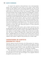
Despite seemingly permanent features, such as Mount Rushmore in
South Dakota, Earth is constantly, albeit slowly, changing. (William Walsh/
iStockphoto)
FOS_Earth Science_DC.indd 4 2/8/10 10:56:26 AM
5
limestone—a sedimentary rock—that contains marine fossils and was
once under water! In 1912 the German researcher Alfred Wegener
(1880–1930) noticed that the coasts of continents such as Africa and
South America seemed to t together and displayed remarkable simi
-
larities in the kind of fossils they contained, as if these now-separated
continents were once adjoined. He proposed the notion of continental
dri and hypothesized that continents had once been joined. Wegener
had a dicult time convincing people that something as massive as a
continent moves, and he was wrong, as it turned out, in some of his
ideas—Wegener was unable to propose a viable mechanism by which
continents move, and he incorrectly believed continents oat across
oceans. But anyone who has ever lived through an earthquake knows
the ground can certainly move.
SEISMIC WaVES
Wiechert, Wegener, and other researchers encouraged their colleagues
to reexamine assumptions about the dynamics and structure of Earth’s
interior. But ideas alone are not suciently convincing. Scientic evi
-
dence that supports a hypothesis or a particular point of view is essential
before the scientic community is willing to accept an idea. Although
obtaining evidence on the nature of Earth’s depths or on any other loca
-
tion
where it is not yet possible to venture is extremely dicult, geolo-
gists
of the early 20th century began using seismic waves as their eyes
into the planet’s interior. ese waves continue to be the most impor
-
tant tool for these studies today.
Waves are important in many branches of science, especially the
study of sound and light, both of which behave (at least under certain
conditions) as waves. A wave is a vibration or disturbance that prop
-
agates across space or in a material such as water or air. To make a
wave, something has to uctuate—electromagnetic elds in the case
of light, air pressure in the case of sound, or water in the case of sea
or lake waves—and it is this uctuation that propagates. For instance,
a stone dropped in a pond will create ripples spreading out from the
point at which the stone fell. e fall of the stone created a disturbance
that moved the water in the small region surrounding the impact zone,
and these water molecules pushed against their neighbors, and so on,
propagating the disturbance throughout the pond.
Exploring Earth’s Depths
FOS_Earth Science_DC.indd 5 2/8/10 10:56:27 AM
earth ScienceS
6
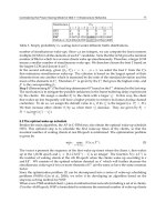
Disturbances can propagate in several dierent ways. A transverse
wave propagates in a direction perpendicular (at a 90 degree angle) to
the vibrations or oscillations, as illustrated in the bottom of the gure
on page 7. Light waves are examples of transverse waves. Inside solid
materials, the side-to-side oscillation (with respect to the direction of
travel) is associated with a kind of force known as shear stress, so these
waves are sometimes called
shear waves, a term geologists oen use be-
cause many of the waves they study travel through solids. e top of
the gure illustrates another kind of wave, called a longitudinal wave,
which propagates in the same direction as the vibrations. Sound waves
are longitudinal waves, since a sound wave consists of a compression
propagating through air, water, or some other material, caused by mol
-
ecules moving toward (and then away) from each other in the same
direction that the wave propagates. e compression gives these waves
an alternative name—
compression waves.
Wave behavior is critical in optics (the study and use of light) and
acoustics (the study and use of sound). Camera lenses form images on
lm or digital sensors by bending and focusing light, and eyeglasses and
contact
lenses perform a similar service for people whose vision would
otherwise be blurry. e focusing is due to refraction—the bending of
the wave when passing from one substance to another. For instance,
when a light wave passes from air into the transparent glass of a lens,
light changes speed, which causes its path to bend, or refract. Another
property of waves that occurs at a boundary between two dierent sub
-
stances is reection—some of the motion is sent back. For example, the
glass of a window transmits a lot of light but also reects some of it, so
an observer looking through a window can see outside but may also
notice his or her reection in the glass.
e speed of waves is also crucial. Waves travel at a specic speed
in the material, or medium, through which the disturbance is propagat
-
ing. In general, compression waves travel faster in a medium that resists
compression. For example, sound waves travel faster in the denser air at
(opposite page) Compression waves consist of contractions and expan-
sions in the same direction (longitudinally) as the propagation of the
wave. Shear or transverse waves consist of up-and-down motions perpen-
dicular to the wave’s propagation.
FOS_Earth Science_DC.indd 6 2/8/10 10:56:27 AM
7
Earth’s surface than the thinner air high in the atmosphere. Chuck Yea-
ger, who in 1947 made the rst documented ight exceeding the speed
of sound, ew at an altitude of about 45,000 feet (13.7 km), where the
Exploring Earth’s Depths
FOS_Earth Science_DC.indd 7 2/8/10 10:56:28 AM
earth ScienceS
8
speed of sound is 660 miles per hour (MPH) (1,056 km/hr), compared
to 760 MPH (1,216 km/hr) at the surface. (Temperature also aects the
speed of sound.) In water, sound waves travel about ve times faster
than in air. In diamond, one of the hardest substances, sound travels
about 40,000 MPH (64,000 km/hr)! Compression waves generally trav
-
el faster than shear waves in solids, since solids tend to be more dicult
to compress than to bend or twist (which is what shear forces will do).
Shear waves do not propagate in water because water does not resist
shear forces.
Seismic recording equipment, part of the Earthquake Arrival Recording
Seismic System (EARSS) in New Zealand (New Zealand © GNS Science/SSPL/
The Image)
FOS_Earth Science_DC.indd 8 2/8/10 10:56:31 AM
9
Seismic or earthquake waves share these properties, and come in
two varieties—compression waves and shear waves. (e term seismic
derives from a Greek word, seismos, meaning shock or earthquake.) An
earthquake is a violent movement of the earth as a result of built-up
stresses that suddenly cause cracks to form and large masses of rock to
move. (Chapter 6 discusses earthquakes in more detail.) is distur
-
bance sends waves propagating out in all directions, just as a clap of
a person’s hands sends sound waves traveling in every direction. e
seismic waves consist of motions of interior rock as well as rocks at
the surface of the planet, along with soil and anything attached to the
surface, such as buildings, roads, and bridges. Geologists record seismic
waves with instruments called seismometers that detect motion in or
along the ground as the waves pass.
Seismometers that are extremely sensitive can detect tremors
from all over the globe, although the energy of a propagating wave
dissipates, or dampens, as it travels because some of the motion is
transformed into heat. Geologists from all over the world maintain
an array of sensors to detect earthquake waves and to pinpoint the
disturbance’s origin, which is called the
earthquake’s
focus. For in-
stance, the United States Geological Survey (USGS), an agency devoted
to Earth science and mapping, maintains a network of about 7,000
earthquake sensor systems in the United States. USGS is an extremely
important contributor to geological research, as described in the fol
-
lowing sidebar.
As the seismic waves spread out from the earthquake’s focus, they
travel at certain speeds. e fastest waves are the compression waves,
which arrive at the sensor stations rst and are called
P waves or pri-
mary waves. P waves travel through rock at an average speed of about
13,000 MPH (20,800 km/hr) and through water and air at about the
same speed as sound.
Secondary waves or S waves are shear waves that
propagate at a little more than half the speed of P waves. Because S
waves are shear waves, they cannot propagate through liquids. Other
types of waves are involved in earthquakes but are less important for
studying Earth’s interior.
In 1935 the California Institute of Technology researcher Charles
Richter (1900–85) established a scale to measure the intensity of earth
-
quakes. e Richter scale, which is still sometimes used, calculates the
magnitude of an earthquake based on seismic wave amplitude—the
Exploring Earth’s Depths
FOS_Earth Science_DC.indd 9 2/8/10 10:56:31 AM
earth ScienceS
10
size or extent of the vibrations. But the speed and type of the seismic
waves, and where they are recorded, are more important for the study
of the planet’s interior.
INSIDE THE PLANET
Seismologists—geologists who study seismic waves—noticed in the
early 20th century that P waves bended, or refracted, in their journey
through Earth. Observations at stations far removed from the earth-
quake focus recorded waves that had traveled through the planet’s in-
terior, as illustrated in part (1) of the gure on page 12. Travel times of
these waves indicated a refracted path, as shown in the gure, and wave
United States Geological Survey (USGS)
Land surveys to delineate boundaries and establish maps have
always been an important function of governments. After the
United States won its independence in the Revolutionary War,
the government established a Surveyor General in 1796 and
tasked this offi ce with surveying western territories. Much of
this land was sold or granted to the public, but the disposi-
tion of mineral lands—areas rich in natural resources—gener-
ated a lot of debate as to who got what and where. The sci-
ence of geology was in its infancy at the time, so people had
trouble determining where the natural resources were buried.
But as the science grew and developed, geologists became
more effective at locating resources, and on March 3, 1879,
President Rutherford Hayes signed a bill establishing a new
agency, the United States Geological Survey (USGS). The job
of this agency was to classify lands according to their geologi-
cal properties and mineral resources.
USGS’s responsibilities have grown tremendously since its
establishment. Although fi nding minerals and natural resources
FOS_Earth Science_DC.indd 10 2/8/10 10:56:32 AM
11
speed is the distance divided by time (as determined by the amount of
time elapsed since the start of the earthquake). Refraction was not too
surprising because the increased pressure in Earth’s interior results in
rmer structures and more resistance to oscillation, so the wave speed
is greater and seismic waves refract. What surprised early seismologists
was that beyond a certain point—about 7,200 miles (11,600 km) from
the focus, at an angular distance of 105 degrees—S waves disappeared!
In 1906 the British seismologist Richard D. Oldham (1858–1936) pro
-
posed that the disappearance of the shear waves was due to the “shadow”
of a liquid core. Since S waves are shear, they cannot propagate through
liquid, so the existence of a liquid center inside the planet would explain
why seismometers fail to record shear waves on the other side of the
remains a valuable service, geologists have expanded their
knowledge and expertise into all aspects of Earth science,
environmental issues, and biological phenomena. USGS em-
ploys 10,000 researchers and support staff to study and un-
derstand the planet and its resources, to reduce the danger
and negative effects of natural disasters such as earthquakes
and landslides, and to manage natural and environmental
resources.
Among the agency’s many projects are Priority Eco-
systems Science, which supports the management of eco-
systems that are of concern and value to society and is
currently studying Florida’s Everglades, San Francisco Bay,
the Mojave Desert, the Platte River, and the Chesapeake
Bay. USGS also maintains the Earthquake Hazards Program
and the Advanced National Seismic System, which monitors
about 20,000 earthquakes occurring in the United States
each year. (Most are too small to be felt, but are important
indicators of stress and strain at various locations.) Other
programs involve energy resources, coastal and marine geol-
ogy, habitats, water resources, fisheries, volcano hazards,
and remote sensing with satellites.
Exploring Earth’s Depths
FOS_Earth Science_DC.indd 11 2/8/10 10:56:32 AM
earth ScienceS
12
planet from the focus, as shown in part (2) of the gure below. P waves,
being compression waves, refract at the boundary between rock and liq-
uid, creating a smaller “shadow.” e rocky interior beneath the crust is
called the mantle, and in 1914 the German seismologist Beno Gutenberg
FOS_Earth Science_DC.indd 12 2/8/10 10:56:34 AM
13
(1889–1960) used the seismic wave results to calculate that the mantle-
core boundary is located at a depth of about 1,800 miles (2,900 km) below
the surface.
However, in 1936 the Danish seismologist Inge Lehmann (1888–
1993) analyzed seismic wave data and discovered an additional refrac
-
tory step of P waves. Her analysis suggested the existence of another
boundary, which she placed at a depth of about 3,200 miles (5,150 km).
is boundary is between an
outer core and an inner core.
e use of seismic waves to image Earth’s interior is similar to the
use of ultrasound waves to image the body’s interior or sound waves in
sonar to image the seaoor. Unlike ultrasound and sonar techniques,
though, seismologists usually do not generate seismic waves—these are
natural occurrences beyond the control of researchers. Yet the waves
reveal a lot of information about otherwise inaccessible places. Seismic
waves are also plentiful; about 1 million or so earthquakes occur each
year in the world, and although most of these are fortunately minor
they are detectable with sensitive instruments.
By studying the nature and speed of seismic waves, geologists have
learned much about the Earth’s interior. Earth consists of the following
several layers:
crust, composed of rocks having
relatively low density, extend
-
ing from the continental surface to an average depth of about
22 miles (35 km) and from the ocean oor an average of about
four miles (6.4 km) down to a boundary known as the
Mohoro-
vicic discontinuity (Moho for short), named aer the Croatian
scientist Andrija Mohorovičić (1857–1936);
mantle, extending from the crust to about 1,800 miles (2,900 km)
below the surface, and divided into an upper and a lower section;
outer core, which is liquid and extends from the mantle border
to a depth of about 3,200 miles (5,150 km);
•
•
•
(opposite page) (1) Boundaries between the layers of Earth’s interior
bends or refracts P waves, causing shifts in speed and altered paths that
leave “shadows”—areas that receive few or no waves.
(2) S waves fail to penetrate the liquid outer core, leaving a large shadow
on the other side of the earthquake’s origin.
Exploring Earth’s Depths
FOS_Earth Science_DC.indd 13 2/8/10 10:56:34 AM
earth ScienceS
14
inner core, which is solid, with a radius of about 750 miles
(1,220 km).
e mantle gets its name from Wiechert, who thought of it as a coat
that covered the core (mantle derives from the German word, mantel,
for “shell” or “coat”). About 67 percent of Earth’s mass is contained in
this large region. e mantle is mostly solid, although as discussed be
-
low there is some degree of uidity in spots; it consists of minerals such
as olivine and another silicate called perovskite (MgSiO
3
). Silicon and
aluminum are less abundant in the mantle compared to the crust, but
magnesium is much more plentiful.
Wiechert assumed from the studies of Earth’s density that the core
must be dense. A greater density for the core also makes sense because
the large portion of the heavier elements would have sunk to the inte
-
rior as the hot, molten planet formed long ago. Iron and nickel possess
relatively high densities and are commonly found in certain meteorites,
indicating their abundance throughout the solar system. ese metals
are likely constituents of the core. e absence of shear wave propaga
-
tion indicates the outer core is liquid, but studies of other seismic waves
indicates
a density slightly less than that expected if the outer core con-
tained only melted iron and nickel. Instead, the outer core is about 90
percent iron and nickel, and most of this is iron—about 85 percent of
the outer core is made of this element. e remaining 10 percent con
-
sists of lighter elements such as sulfur and oxygen.
e inner core forms a boundary with the outer core, reecting
some of the waves and transmitting the rest. Shear waves cannot pass
through the outer core, but as compression waves cross the boundary
between the inner and outer core, some of these disturbances create
shear waves. e shear waves travel through the inner core and get con
-
verted back into compression waves as they proceed from the inner to
the outer core. Seismologists can detect the paths of these waves, and
the propagation of shear waves in the inner core implies it cannot be
liquid. Density studies suggest the inner core is mostly solid iron, mixed
with a small percentage of nickel.
Researchers continue to study seismic waves and similar data to
learn more of the details on the structure and composition inside Earth.
In 2005 John W. Hernlund
and Paul J. Tackley of the University of Cali
-
fornia,
Los Angeles, and Christine omas of the University of Liver-
•
FOS_Earth Science_DC.indd 14 2/8/10 10:56:34 AM
15
pool in the Britain found data suggesting the presence of a thin layer
around the mantle-core boundary. is layer, previously unknown and
not yet widely studied, might help scientists to understand and identify
further properties of the mantle. e researchers published their report
“A Doubling of the Post-Perovskite Phase Boundary and Structure of
the Earth’s Lowermost Mantle” in a 2005 issue of
Nature.
Although researchers can study the ner structure of Earth’s hid-
den interior with sensitive seismometers, a large amount of information
could also be gained by burrowing inside and taking a look. ere are
limitations on how far down people can drill, even with the hardest bits
(the tip of the drill), but researchers are sharpening their drill bits in the
eort to reach greater depths.
dRIllInG Into EaRtH
Oil companies have drilled thousands of wells to extract subsurface
oil. ese wells range in depth from about 1,000 feet (305 m) to about
23,000 feet (7,000 m) and sometimes a little deeper. e deepest hole
anyone has ever drilled as of 2009 is in Russia’s Kola Peninsula, which
is located in the northern part of the country, although the drillers were
not searching for natural resources but instead were exploring how far
down
they could go. By the late 1980s, Russian scientists working in the
Kola Peninsula reached a depth of 40,220 feet (12,262 m)—7.6 miles
(12.26 km)!
Drilling to such depths is an extremely demanding operation. As
the depth increases, the pressure increases and the rocks get harder,
which results in slower progress and higher costs. Temperature also
rises, as discussed in the following section, and the increased pressure
and temperature greatly reduce the useful life of the expensive drill bits
needed to cut through the hard earth (these drill bits cost $50,000 and
sometimes even more). Controlling the drill and guiding its trajectory
are not easy when the hole gets deep, and removing the cuttings from a
great depth requires a lot of time and eort.
ese diculties make deep drilling a formidable task. But the di
-
culties have not stopped geologists from attempting ambitious projects.
A U.S. project began in 1958 with the goal of drilling all the way to the
Mohorovicic discontinuity, the boundary between crust and mantle.
is project, called Project Mohole, would have been the rst to reach
Exploring Earth’s Depths
FOS_Earth Science_DC.indd 15 2/8/10 10:56:35 AM
earth ScienceS
16
the mantle, if it had been successful. Project Mohole failed to attain
its primary goal, as discussed in the sidebar on page 18, due to budget
problems and other daunting issues that the research team could not
overcome.
Although Project Mohole failed to reach the mantle, a project
with similar goals has recently emerged. Led by the Japan Agency for
Marine-Earth Science and Technology (JAMSTEC), the project has
been called Chikyu Hakken (“Earth discovery”). e primary objec
-
tives of this project are to observe and sample Earth’s depths to obtain
information about the nature and origin of earthquakes, as well as
the structure and evolution of the planet. To achieve these ambitious
goals, JAMSTEC ordered and received a vessel D/V
Chikyu in July
2005. (D/V stands for drilling vessel.) Researchers and technicians
outtted the 689-foot (210-m) vessel with a drill system capable of
An oil rig platform off the California coast (Chad Anderson/iStockphoto)
FOS_Earth Science_DC.indd 16 2/8/10 10:56:36 AM
17
drilling in 8,200 feet (2,500 m) of water and able to bore 23,000 feet
(7,000 m)—4.3 miles (7 km)—into the seaoor. Chikyu cost about
$550 million.
As part of the Integrated Ocean Drilling Program (IODP), sup
-
ported by the United States and Japan with help from the European
Union, China, and South Korea,
Chikyu made its rst expedition be-
ginning in late 2007. In this rst outing, researchers sailed to the Nan-
kai Trough, an area of the Pacic Ocean o Japan’s coast that has been
the site of numerous earthquakes. Drilling in about 6,560 feet (2,000
m) of water,
Chikyu cut a number of holes ranging in depth from
1,300 feet (400 m) to 4,600 feet (1,400 m) beneath the ocean oor. e
sampled material proved to be relatively fresh as far as geology goes
(4–6 million years) and appeared to be experiencing unusual amounts
of stress.
Future
Chikyu expeditions will drill even deeper holes. With its
capacity to reach 4.3 miles (7 km) beneath the seabed, Chikyu should
be able to achieve Project Mohole’s goal of drilling into the mantle—
the rst time this layer will have ever been reached.
HEat oF EaRtH’S IntERIoR
One of the most interesting aspects of drilling into Earth is the rise in
temperature with depth. is is not all that surprising to those people
who have seen a volcano erupt and spew vast amounts of hot, molten
rock called
lava. e material comes from inside the planet, at places
where hot, molten rock called magma has risen through cracks. (Lava
is the term for this molten rock aer the eruption; magma is generally
the term used for subsurface molten rock.) Magma rises through these
cracks because it is hotter and less dense than surrounding rock, similar
to the way that hot air rises.
Visitors to Carlsbad Caverns, a group of caves in New Mexico,
can descend about 830 feet (253 m) below the surface (some parts of
the cave are deeper but not publicly accessible). Most visitors wear
jackets because the temperature in these caves is about 56°F (13°C)
all year. Although this temperature is cooler than the surface in sum
-
mer months, the lack of sunlight and air movement results in a steady
temperature. Geologists have measured Earth’s temperature in mines
Exploring Earth’s Depths
FOS_Earth Science_DC.indd 17 2/8/10 10:56:36 AM
earth ScienceS
18
with depths as great as 2.3 miles (3.78 km) and in smaller holes three
or more times as deep, and these measurements show an average tem-
perature increase of about 72°F/mile (25°C/km) in the crust, although
the rate varies.
However, a temperature increase of 72°F/mile (25°C/km) cannot
hold true throughout the mantle. At such a high rate, the lower regions
of the mantle would be molten, but this is not consistent with seismic
Project Mohole—An Ambitious
Attempt to Reach Earth’s Mantle
Project Mohole was an attempt to drill a hole to the mantle
and retrieve a sample from this great frontier—a frontier
separated by vast quantities of hard rock. Suggested in
1957 by Walter Munk, a member of the U.S. National Acad-
emy of Sciences, the project got funds for preliminary work
in 1958 from the National Science Foundation (NSF), one of
the main government agencies that supports basic scientifi c
research. A sample from the mantle would provide a large
amount of information on the exact composition of this layer,
its age, and internal dynamics. The question of mantle dy-
namics was particularly important during this time period,
as continental drift was being hotly debated.
The thickness of Earth’s crust varies widely, and the thin-
nest section is beneath the ocean. In some areas of the sea-
fl oor, the crust is only about three miles (4.8 km) thick, al-
though the average is considerably more. The plan of Project
Mohole consisted of three phases, the fi rst of which was an
experimental program to develop techniques to drill through
deep water and into the crust. Drilling for oil in the rela-
tively shallow areas of the sea is common, but Mohole scien-
tists needed to drill in deeper parts of the oceans, in places
where the crust is thinner. In the fi rst phase of the project,
beginning in early 1961, researchers drilled in 11,700 feet
(3,570 m) of water off Guadalupe, Mexico. The platform was
FOS_Earth Science_DC.indd 18 2/8/10 10:56:37 AM
19
wave observations. e temperature gradient—change in temperature
with depth—must be less in the mantle than in the upper part of the
crust. Although the gradient cannot be measured directly, seismolo
-
gists can make estimates based on seismic waves, taking advantage of
the properties that depend on the nature of the rock through which
the waves are traveling. For example, seismologists can determine the
depth at which rocks begin to change phase, or state. Rocks change
a ship named CUSS I, a converted naval barge. (The ship’s
name came from the initial letters of the names of oil com-
panies that had outfitted the ship—Continental, Union, Shell,
and Superior.) Researchers drilled a series of holes, one of
which extended into the ocean crust to a depth of 557 feet
(170 m). Although this does not seem very far, the project
became the first to drill successfully in deep water.
Phase two never got started. Cost estimates ballooned
from $5 million to nearly $70 million. Although Phase one
had succeeded, the project called for drilling through even
deeper water and farther into the crust below, but no one
was able to think of a cost-effective means of doing this.
Project Mohole lost its funding in 1966 amid arguments
about how the project should proceed and whether it was
worth the money. (Another budget problem faced by Project
Mohole was the existence of an even bigger and more ex-
pensive project that was competing for funds at the same
time—the Apollo Moon landings.)
The project’s failure was an embarrassment to the NSF,
since the promising beginning had crumbled so quickly. A
journalist Daniel S. Greenberg wrote a series of articles
on the project in 1964 for Science magazine, and, as he
watched the plan disintegrate, he wrote, “The Mohole busi-
ness is a very sorry episode. . . .” Yet Project Mohole was
not a complete failure, and geologists were able to identify
a second sublayer of crust, consisting of rock called basalt,
from the samples obtained at 557 feet (170 m) in the ocean
crust.
Exploring Earth’s Depths
FOS_Earth Science_DC.indd 19 2/8/10 10:56:37 AM
earth ScienceS
20
phase at certain temperatures and pressures, allowing geologists to cal-
culate the temperature of these depths. Observations suggest that the
mantle’s temperature gradient is about 1.5°F/mile (0.5°C/km), much
lower than the crust’s.
Where does this heat come from? Earth’s interior is hot for two
main reasons. One source of heat is
radioactivity—atoms of certain ele-
ments such as uranium and thorium undergo a natural process in which
the atom’s nucleus experiences a transformation, or decay, emitting en
-
ergy in the form of radiation. Nuclear reactors use this same process to
generate enough heat to turn huge turbines, producing large amounts
of electricity. Radioactive atoms in Earth’s interior are responsible for
some of the heat inside the planet. e other source of heat is the rem
-
nants of energy created as bits of matter slammed into each other dur-
ing Earth’s creation. Although Earth formed billions of years ago, the
violent collisions generated a lot of heat that remains trapped inside the
planet.
A view inside Carlsbad Caverns near Devil’s Spring (Glenn Frank/iStockphoto)
FOS_Earth Science_DC.indd 20 2/8/10 10:56:38 AM
21
Earth’s core must be extremely hot. Unable to make a direct mea-
surement, geologists can only estimate the core’s temperature based on
seismic wave calculations of pressure and composition. e tempera
-
ture of the outer core probably exceeds 5,430°F (3,000°C). Even more
uncertainty exists about the inner core’s temperature, which may be as
high as 14,400°F (8,000°C).
Hot objects cool o in three ways—radiation,
convection, and con-
duction. Conduction carries away heat by contact with another object,
such as the heat transfer that occurs when a person’s nger comes into
contact with a hot skillet. Convection involves currents such as air or
liquid to carry away heat, such as the cooling eect of a sea breeze or
fan. Radiation involves atomic emissions of electromagnetic energy
in a frequency range that is commonly infrared—hot objects emit a
lot of infrared radiation. Earth’s surface radiates heat, which lowers
the temperature (especially at night, when no sunlight is available to
replenish it), but subsurface radiation does not escape. Heat from the
interior ows through the depths by conduction and convection. e
extent and mechanisms by which these processes occur are extremely
important in understanding the structure of Earth’s depths—and the
movement of large chunks of
crust and mantle.
tECtonIC PlatE MoVEMEnt
Although Wegener’s notion of continental dri was not entirely cor-
rect, researchers such as Harry Hess (1906–69) at Princeton Univer-
sity and Robert Dietz (1914–95) of Scripps Institution of Oceanogra-
phy realized that Earth’s crust separates at certain points in the middle
of the ocean. At these sites, known as mid-ocean ridges, molten rock
oozes upward to form a new seabed. A section of the Mid-Atlantic
Ridge is shown in the gure. What causes the separation is the move
-
ment of rigid plates called tectonic plates, which were rst postulated
by the Canadian researcher J. Tuzo Wilson (1908–93) in 1965. e
term
tectonic derives from a Greek word, tektonikos, meaning “of a
builder.”
Earth’s crust is composed of 12 large plates and a few dozen smaller
ones. Plate boundaries do not necessarily follow continental boundar
-
ies, and the depth of the plates includes the crust plus a little bit of the
upper part of the mantle. e crust and uppermost mantle composes
Exploring Earth’s Depths
FOS_Earth Science_DC.indd 21 2/8/10 10:56:39 AM
earth ScienceS
22
the lithosphere (from lithos, a Greek term for stone), which averages
about 60 miles (100 km) in thickness. ese rigid plates move around
the surface and collide with other plates or move apart. A collision may
send one plate buckling under the other, or the two plates may slide past
one another. e motion is slow, in a range of 1–6 inches (2.5–15 cm)
per year.
Plate movements have greatly a ected the con guration of Earth’s
surface. At one time, millions of years ago, the seven continents were
joined in one supercontinent known as Pangaea. (Named by Wegener,
the term Pangaea is Greek for “all land.”) e motion of the plates also
helps explain earthquakes and volcanoes. For instance, a ssure or fault
known as the San Andreas Fault in California lies around a boundary
between two plates that grind past each other and periodically slip,
causing earthquakes.
e forces at work to move the plates are of great interest to geolo-
gists. Plate motion requires some sort of exibility in the layer of mantle
on which the plates rest. is layer is known as the asthenosphere (from
asthenēs, a Greek term for “weak”). Although the asthenosphere is not
fully molten, it is not as rigid as the lithosphere, and is hot enough to
deform or ow. An important component of this ow is a slow up-and-
Two plates separate and move apart to form part of the Mid-Atlantic
Ridge.
FOS_Earth Science_DC.indd 22 2/8/10 10:56:50 AM
23
down circulation known as convection currents, which are driven by
heat; hot material rises, cools as it loses heat to the surface, then falls
back down, repeating the circulation when the deeper regions warm it
up again.
Although geologists believe that motion from convection currents
in the mantle drives the lithospheric plates, no one is certain exactly
how this occurs or how far down the convection currents extend. A
better understanding of these currents and their interaction with the
plates would enhance geological knowledge on a variety of issues, in
-
cluding earthquakes and volcanoes. e discovery and modeling of
new layers, such as the one found by Hernlund, Tackley, and omas,
will help.
Careful monitoring of the plates reveals interesting plate motions
that do not come directly from earthquakes—in other words, aseismic
motions—the study of which may help explain the underlying pro
-
cesses. With global positioning system (GPS) equipment, which allows
precision position measurements, geologists can detect subtle changes.
With such sensitive instruments, Vladimir Kostoglodov of the National
Autonomous University of Mexico and his colleagues detected a brief
reversal in the motion of the plate at Guerrero, Mexico, that they cannot
explain. e eect this strange motion may have on earthquake hazards
in
the area is unknown. Further research into the activity of Earth’s in
-
terior is needed to clarify the issue.
dynaMICS and IntERaCtIonS oF
EaRtH’S IntERIoR
Plate movements and mantle convection currents demonstrate how
dynamic and changing Earth can be. Although these changes happen
slowly, they produce signicant eects, such as the rearrangement of
the planet’s surface.
Another important eect is the creation of Earth’s strong
magnetic
eld. A magnet has two magnetic poles, north and south, and Earth be-
haves in many ways as a gigantic magnet, with the north pole of the
magnet somewhat close to the North Pole (which is located along the
planet’s rotational axis), and similarly for the south pole. is eld
Exploring Earth’s Depths
FOS_Earth Science_DC.indd 23 2/8/10 10:56:50 AM
earth ScienceS
24
aligns compass needles and deects charged particles in space, creating
spectacular displays of light such as aurora borealis (northern lights)
and aurora australis (southern lights), as if there was a huge magnet
embedded in the planet. But the cause of Earth’s magnetic eld is not a
permanent magnet inside the planet; although the core is mostly iron,
which is a highly magnetic material, the high temperatures of Earth’s
interior disrupt iron’s magnetic properties, and the core is too hot to
behave like an ordinary magnet. As described in chapter 2, geologists
believe that convection currents in the iron core generate Earth’s mag
-
netic eld. e mechanism that produces the eld is sometimes called
a geodynamo.
Interactions also play a role in the properties and behavior of Earth’s
interior. e boundaries between layers are crucial in transmitting or
reecting seismic waves and serve as the sites where two dierent ma
-
terials come into contact and interact. For example, the liquid outer
core, rich in metals, and the silicate rock of the deepest mantle meet at
a depth of about 3,200 miles (5,150 km).
e great depth of regions, such as the mantle-core boundary,
makes these areas impossible to sample directly. Yet
geologists are de
-
veloping other means to study possible interactions.
Leslie
A. Hayden and E. Bruce Watson, researchers at Rensselaer
Polytechnic Institute in Troy, New York, have found a mechanism by
which metal atoms from the core can leak, or diuse, across the bound
-
ary. ese researchers studied the mantle-core boundary by creating an
articial boundary in the laboratory. ey constructed a silicate mate
-
rial having a composition similar to what geologists believe is in the
mantle and placed it next to metallic material. en the researchers
heated and pressurized the materials to reproduce conditions in Earth’s
interior at the depth of the mantle-core boundary. Hard rock, especially
under high pressure, would seem to oer few if any avenues for metals
to enter, yet Hayden and Watson discovered metal atoms crossed the
boundary. ese metals included elements that exist in small quanti
-
ties in the core, such as gold and platinum. What causes the atoms to
move across the boundary is not clear, but the researchers propose the
atoms diuse between crystals, or grains, of the rock. Hayden and Wat
-
son published their ndings, “A Diusion Mechanism for Core-Mantle
Interaction,” in a 2007 issue of
Nature. Such interactions may play
a
FOS_Earth Science_DC.indd 24 2/8/10 10:56:50 AM
25
vital role in the distribution of elements and the chemical composition
of Earth’s interior.
CHaRtInG tHE dEPtHS WItH
RESEaRCH In tHE laboRatoRy
e experiments of Hayden and Watson illustrate the use of experi-
mental techniques to study phenomena hidden far below the surface
of the planet. Equipment to generate high temperatures and pressures
that mimic Earth’s interior has allowed geologists to bring some of their
studies into the laboratory. One of the most common laboratory tools
is the diamond anvil cell.
Diamonds are the hardest natural material, which makes them ex
-
cellent components for a cell, or container, in which high pressure is to
be generated. An anvil is a block capable of withstanding high pressures
or hammering, such as the steel anvil on which metalworkers once ham
-
mered and molded swords and other objects. In a diamond anvil cell,
two blocks made of diamond press against the material to be studied,
squeezing it and exerting tremendous pressure.
Considering the high cost of diamonds and other suciently hard
substances, these anvil cells are not usually very large. As a result, most
laboratories can subject only a small amount of material to high pres
-
sures in any
given experiment. Maintaining a high temperature is also
a
problem, since heat readily ows out of the anvils, and the high tem
-
peratures can weaken the diamonds by loosening their structure. Yet
these cells can exert a pressure in excess of 1 million times as strong as
the atmosphere—comparable to the pressure at Earth’s center.
Geologists who use diamond anvil cells and similar equipment can
study the properties that rocks have under the extreme conditions of
Earth’s interior. For example, Jonathan C. Crowhurst of the Lawrence
Livermore National Laboratory in California, along with colleagues at
the University of Washington, Carnegie Institution of Washington in
Washington, D.C., and Northwestern University in Illinois, studied a
mineral known as ferropericlase. is mineral, which consists of mag
-
nesium (Mg), iron (Fe), and oxygen (O), is common in the lower depths
of the mantle. (Although no one has sampled the mantle directly, the
Exploring Earth’s Depths
FOS_Earth Science_DC.indd 25 2/8/10 10:56:51 AM
earth ScienceS
26
study of seismic waves and the analysis of material such as magma and
diamonds that have risen from the depths have given geologists some
idea of mantle composition.)
Crowhurst and his colleagues applied pressures of up to about
600,000 times that of Earth’s atmosphere to ferropericlase and then
measured a property known as spin transition. is property has an
important eect on elasticity—how readily the molecules of a substance
move around—which inuences the conduction of seismic waves and
is critical for the study of the mantle. As the authors wrote in their re
-
port, “Elasticity of (Mg,Fe)O rough the Spin Transition of Iron in
the Lower Mantle,” in a 2008 issue of Science, “Because knowledge of
this deep and inaccessible region is derived largely from seismic data, it
is essential to determine the inuence of the spin transition on elastic
wave velocities at lower-mantle pressures.”
Many materials change properties at high pressure and tempera
-
ture. But Crowhurst and his colleagues discovered that ferropericlase
experienced more changes than had been expected, causing the speed of
seismic waves to slow down a little bit. is nding is important to seis
-
mologists, who must take these factors into account during the analysis
of seismic wave data.
Advances
in computers have also created valuable opportunities for
geologists. e fastest computers, known as supercomputers, perform
trillions of operations per second. Geologists simulate the physical and
chemical properties of matter with sophisticated computer soware,
including programs that incorporate mathematical equations describ
-
ing these properties and the interactions of matter at extremely high
temperature and pressure. Simulations always rely on the accuracy of
scientic knowledge—if the properties and interactions incorporated
into the computer program are wrong, the results will also be wrong.
But if geologists are careful to use the ndings of previous experiments,
such as laboratory experiments using diamond anvil cells, a computer
simulation is a useful tool. A computer simulation lets geologists ex
-
plore down to the atomic level what may be happening all the way in-
side Earth’s core.
Anatoly B. Belonoshko at the Royal Institute of Technology in
Stockholm, Sweden, and his colleagues simulated iron atoms under the
conditions the atoms experience in the inner core. When in the solid
phase, iron atoms adopt a certain geometric conguration, as do many
FOS_Earth Science_DC.indd 26 2/8/10 10:56:51 AM
27
other atoms. is conguration forms a repeating structure called a
crystal. Belonoshko and his colleagues conducted computer simulations
of iron to indicate what sort of crystal structure may exist in Earth’s
inner core.
One of the reasons crystal structure is important is that it will in
-
uence elasticity and therefore seismic wave conduction. Seismologists
have determined that the inner core shows elastic anisotropy, which
means that its elastic properties depend on direction. For example,
seismic waves travel faster when they are moving in the same direc
-
tion as Earth’s axis than when they are moving perpendicular to this
direction.
What causes this anisotropy? One possible explanation is that the
iron crystals composing the core have a particular orientation, so that
waves traveling along this direction would have a dierent speed than
waves traveling, say, perpendicular to it. But iron tends to become
isotropic—without orientation—at high temperature and pressure.
As an alternative hypothesis, Belonoshko and his colleagues sug
-
gested that iron in the core adopts a certain crystal pattern called
body-centered cubic, in which the atoms form a cube with an atom
in the middle. e researchers conducted simulations using a method
called molecular dynamics, which incorporates atomic interactions.
In their report,
“Elastic Anisotropy of
Earth’s Inner Core,” published
in a 2008 issue of
Science, Belonoshko and his colleagues wrote, “We
show, by molecular dynamics simulations, that the body-centered
cubic iron phase is extremely anisotropic to sound waves despite its
high symmetry. Direct simulations of seismic wave propagation re
-
veal an anisotropy of 12 percent, a value adequate to explain the an-
isotropy of the inner core.” ese simulations suggest that the core’s
anisotropy is not due to a particular orientation of the iron but to the
crystal itself.
ConCluSIon
Geologists will continue to complement eld studies and seismic wave
observations with laboratory experiments and computer simulations.
Advanced technologies such as the drilling vessel
Chikyu create oppor-
tunities for researchers to explore previously unreachable depths, and
the samples obtained from these operations will enhance knowledge of
Exploring Earth’s Depths
FOS_Earth Science_DC.indd 27 2/8/10 10:56:51 AM