Building A Geodatabase _ Xây dựng cơ sở dữ liệu trong GIS
Bạn đang xem bản rút gọn của tài liệu. Xem và tải ngay bản đầy đủ của tài liệu tại đây (9.19 MB, 490 trang )
Building a Geodatabase
Andrew MacDonald
GIS by ESRI
™
Copyright © 19992001 ESRI.
All rights reserved.
Printed in the United States of America.
The information contained in this document is the exclusive property of ESRI. This work is protected under United States copyright law and the
copyright laws of the given countries of origin and applicable international laws, treaties, and/or conventions. No part of this work may be reproduced
or transmitted in any form or by any means, electronic or mechanical, including photocopying and recording, or by any information storage or retrieval
system, except as expressly permitted in writing by ESRI. All requests should be sent to Attention: Contracts Manager, ESRI, 380 New York Street,
Redlands, CA 92373-8100, USA.
The information contained in this document is subject to change without notice.
CONTRIBUTING WRITERS
Tom Brown, Julio Andrade, Erik Hoel, and Jonathan Bailey.
U.S. GOVERNMENT RESTRICTED/LIMITED RIGHTS
Any software, documentation, and/or data delivered hereunder is subject to the terms of the License Agreement. In no event shall the U.S. Government
acquire greater than RESTRICTED/LIMITED RIGHTS. At a minimum, use, duplication, or disclosure by the U.S. Government is subject to restrictions
as set forth in FAR §52.227-14 Alternates I, II, and III (JUN 1987); FAR §52.227-19 (JUN 1987) and/or FAR §12.211/12.212 (Commercial Technical
Data/Computer Software); and DFARS §252.227-7015 (NOV 1995) (Technical Data) and/or DFARS §227.7202 (Computer Software), as applicable.
Contractor/Manufacturer is ESRI, 380 New York Street, Redlands, CA 92373-8100, USA.
ESRI, ArcView, SDE, and the ESRI globe logo are trademarks of ESRI, registered in the United States and certain other countries; registration is
pending in the European Community. ArcInfo, ArcSDE, ArcCatalog, ArcMap, ArcToolbox, ArcStorm, ArcEditor, ArcGIS, ArcObjects, StreetMap, the
ESRI Press logo, and GIS by ESRI are trademarks and www.esri.com and www.arconline.esri.com are service marks of ESRI.
The names of other companies and products herein are trademarks or registered trademarks of their respective trademark owners.
Attribution_page.p65 01/26/2001, 11:32 AM1
iii
1 Introduction 1
Before you create your geodatabase 3
Three ways to create a geodatabase 4
Geodatabases and ArcCatalog 8
The first step: creating your database 9
Tips on learning how to build geodatabases 14
2 Quick-start tutorial 15
Exercise 1: Organizing your data in ArcCatalog 18
Exercise 2: Importing data into your geodatabase 20
Exercise 3: Creating subtypes and attribute domains 24
Exercise 4: Creating relationships between objects 29
Exercise 5: Building a geometric network 31
Exercise 6: Creating annotation 36
Exercise 7: Creating layers for your geodatabase data 41
Exercise 8: Editing your geodatabase 44
3 Creating new items in a geodatabase 55
Geodatabase items 56
Creating tables 61
Creating feature datasets 65
Creating feature classes 71
Creating indexes 79
Granting and revoking privileges 82
4 Migrating existing data into a geodatabase 83
How data is converted 84
Importing shapefiles 96
Importing coverages 102
Importing tables 109
Importing a geodatabase feature class 111
Contents
Ch00_Contents.p65 01/26/2001, 11:45 AM3
iv BUILDING A GEODATABASE
Importing a CAD feature class 114
Importing rasters 115
Copying geodatabase data 121
Loading data into existing simple feature classes and tables 123
Registering ArcSDE layers and tables with the geodatabase 127
Analyzing geodatabase data 128
5 Subtypes and attribute domains 129
What are subtypes and attribute domains? 130
Working with attribute domain properties 134
Browsing the attribute domains of a geodatabase 135
Creating new attribute domains 137
Modifying and deleting attribute domains 140
Associating default values and domains with tables and feature classes 141
Creating subtypes 142
Modifying and deleting subtypes 145
6 Defining relationship classes 147
What is a relationship class? 148
Relationship classes in ArcCatalog and ArcMap 152
Creating a simple relationship class 154
Creating a composite relationship class 158
Creating an attributed relationship class 161
Creating relationship rules 163
Managing relationship classes 165
Exploring related objects in ArcMap 166
Using related fields in ArcMap 169
7 Managing annotation 171
Annotation in the geodatabase 172
Annotation and ArcCatalog 175
Creating annotation classes 176
Ch00_Contents.p65 01/26/2001, 11:45 AM4
CONTENTS v
Converting labels to annotation 181
Converting coverage annotation to geodatabase annotation 183
8 Dimensioning 185
Dimensions in the geodatabase 186
Dimensions and ArcCatalog 189
Creating dimension feature classes 190
Creating and managing dimension styles 195
9 Geometric networks 205
What is a geometric network? 206
Geometric networks and ArcCatalog 210
Creating geometric networks 211
Creating a new geometric network 216
Building a geometric network from existing simple feature classes 220
Adding new feature classes to your geometric network 228
Network connectivity: defining the rules 231
Establishing connectivity rules 232
Managing a geometric network 234
10 Geocoding services 235
Geocoding services 236
Geocoding services in ArcCatalog and ArcMap 238
Preparing reference data for a geocoding service 240
Creating a geocoding service 245
Maintaining geocoding indexes 248
Maintaining geocoding indexes 250
Preparing address data for geocoding 256
Ch00_Contents.p65 01/26/2001, 11:45 AM5
vi BUILDING A GEODATABASE
11 Building geodatabases with CASE tools 259
What are CASE tools? 260
Creating UML packages and static structure diagrams 271
Setting tagged values 272
Creating feature datasets 273
Creating feature classes 274
Creating relationship classes 278
Creating domains 283
Creating subtypes 288
Creating relationship rules 294
Creating geometric networks 296
Creating connectivity rules 298
Extending classes with custom behavior 303
Exporting your UML model to the repository 309
Checking your model for errors 311
Generating schema from the repository 312
Selecting feature datasets 316
Setting properties for object classes (tables) 317
Setting properties for feature classes in a feature dataset 320
Setting properties for relationship classes 323
Creating the schema 325
12 Editing your geodatabase 327
Editing in ArcMap and your geodatabase 328
Managing the edit cache 332
Editing with default values and attribute domains 334
Editing relationships 341
Editing relationships and related objects 346
Editing annotation 365
Editing network features 374
Editing dimension features 395
Loading objects from other feature classes 428
Ch00_Contents.p65 01/26/2001, 11:45 AM6
CONTENTS vii
13 Working with a versioned geodatabase 435
Integrating versioning with your organizations work flow 436
Registering data as versioned 438
Creating and administering versions in ArcCatalog 439
Working with versions in ArcMap 446
Editing and conflict resolution 449
Editing a version 454
Versioning scenarios 458
Glossary 461
Index 471
Ch00_Contents.p65 01/26/2001, 11:45 AM7
Ch00_Contents.p65 01/26/2001, 11:45 AM8
IN THIS CHAPTER
1
Introduction
1
• Before you create your geodata-
base
Three ways to create a geodata-
base
Geodatabases and ArcCatalog
• The first step: creating your data-
base
Tips on learning how to build
geodatabases
The geodatabase supports a model of topologically integrated feature
classes, similar to the coverage model. It also extends the coverage model
with support for complex networks, relationships among feature classes,
and other object-oriented features. The ESRI
®
ArcGIS applications
(ArcMap, ArcCatalog, and ArcToolbox) work with geodatabases as
well as with coverages.
The ArcInfo geodatabase model is implemented on standard relational
databases with the ArcSDE application server. ArcSDE defines an open
interface to database systems for our users. It allows ArcInfo to manage
geographic information on a variety of different database platforms including
Oracle
®
, Microsoft
®
SQL Server, IBM
®
DB2
®
, and Informix
®
.
The geodatabase model defines a generic model for geographic information.
This generic model can be used to define and work with a wide variety of
different user- or application-specific models. By defining and implementing
a wide variety of behavior on a generic geographic model, we provide a
robust platform for the definition of a variety of user data models.
The geodatabase model supports an object-oriented vector data model. In
this model, entities are represented as objects with properties, behavior, and
relationships. Support for a variety of different geographic object types is
built into the system. These object types include simple objects, geographic
features (objects with location), network features (objects with geometric
integration with other features), annotation features, and other more
specialized feature types. The model allows you to define relationships
between objects, together with rules for maintaining the referential integrity
between objects.
Ch1.p65 02/08/2001, 10:16 AM1
2 BUILDING A GEODATABASE
This book describes how to take your geodatabase design
and implement it with ArcInfo 8. ArcCatalog has various
tools for creating and modifying your geodatabase schema,
while ArcMap has tools for analyzing and editing the
contents of your geodatabase.
Successfully implementing a multiuser GIS system with
ArcInfo and ArcSDE starts with a good data model design
and database tuning. How the data is stored in the
database, the applications that access it, and the client and
server hardware configurations are all key factors to a
successful multiuser GIS system. Designing a geodatabase
is a critical process that requires planning and revision until
you reach a design that meets your requirements and
performs well. Throughout this book, guidelines for good
data modeling of each aspect of the geodatabase are
discussed to help you implement a successful multiuser GIS
system with ArcInfo, either with ArcSDE or with a
personal geodatabase.
A critical part of a well-performing geodatabase is the
tuning of the database management system (DBMS) in
which it is stored. This tuning is not required for personal
geodatabases; however, it is critical for ArcSDE
geodatabases. For more information on tuning your
database for ArcSDE and the geodatabase, see the
Configuration and Tuning Guide for <DBMS> PDF file.
Once you have a design, you can create the geodatabase
and its schema by loading existing shapefile and coverage
data, creating new database items with ArcCatalog, using
Unified Modeling Language (UML) and Computer-Aided
Software Engineering (CASE) tools, or a combination of all
three.
Ch1.p65 01/18/2001, 2:01 PM2
INTRODUCTION 3
One of the most important steps in creating an effective database
is designing its schema. The same is true for any geodatabase.
When designing a geodatabase, you should consider questions
like:
What kind of data will be stored in the database?
In what projection do you want your data stored?
Do you want to establish rules about how the data can be
modified?
How do you want to organize your object classes and
subtypes?
Do you want to maintain special relationships between
objects of different types?
Will your database contain networks?
Will your database store custom objects?
Once you have answered these and other questions, you are
ready to begin creating your geodatabase design. You can use
the data modeling guidelines in this book to help you design a
geodatabase which both meets your requirements and also
performs well. This book will then guide you through the process
of physically implementing your geodatabase design.
Before you create your geodatabase
Ch1.p65 01/18/2001, 2:01 PM3
4 BUILDING A GEODATABASE
Three ways to create a geodatabase
Once you have designed your geodatabase, you can employ any
of three methods to create a new geodatabase. The method you
choose will depend on what the source of your geodatabase data
is, whether you will store custom objects in the geodatabase, or
whether you intend to create a new geodatabase from scratch. In
practice, you will often use a combination of all or some of the
methods outlined.
The three methods of creating a geodatabase are discussed
briefly here. Subsequent chapters will outline how each task is
performed.
Three Methods to Create a Geodatabase
Use CASE tools
MS
Repository
ArcCatalog
3
Create schema with
ArcCatalog
1
Shapefiles
Coverages
Geodatabase
schema
Load data into schema
Define connectivity rules
Define relationships
Geodatabase
Shapefiles
Coverages
Import existing data
Define subtypes and
attribute domains
10"
5"
3"
Build geometric
networks
2
What data?
Location and projection?
Feature classes and subtypes?
Geometric networks?
Rules?
Relationships?
Design your geodatabase
Ch1.p65 01/18/2001, 2:01 PM4
INTRODUCTION 5
Migrating existing data into the geodatabase
It is very likely that you already have data in various formats
shapefiles, coverages, INFO tables, and dBASE
®
tablesthat
you want to store in a geodatabase.
You may also have your data stored in
other multiuser geographic information
system (GIS) data formats such as
ArcStorm, Map LIBRARIAN, and
ArcSDE.
Through ArcCatalog, you can convert
data stored in one of these formats to a
geodatabase by importing it. A series of
dialog boxes will guide you through the
conversion process. Once you have
become familiar with this process, more
advanced batch data converters can be
used to perform these operations more
efficiently.
When converting data from one of
these formats into the geodatabase,
both the spatial and nonspatial
component of each object is translated. For example, when
converting a shapefile to a feature class, both the shapes
(geometry) and attributes are stored in the geodatabase.
Attributes can be left out or renamed. Shapefiles of the same
spatial extent can be imported into the same feature dataset. All or
some of the feature classes from a coverage can be imported into
an integrated feature dataset.
Converting ArcStorm and Map LIBRARIAN data is done using
tools that are similar to those used for importing coverages.
However, you must use ArcSDE for Coverages before ArcCatalog
or ArcToolbox can access and display ArcStorm and Map
LIBRARIAN data.
The first step is always to design the geodatabase. This book and
the book Modeling Our World are guides to help you design
your geodatabase. Once this design is complete, you can proceed
with the method that best suits your situation.
Creating a new geodatabase from scratch
In some cases, you may not yet have any data that you want to
load into a geodatabase, or the data you have to load only
accounts for part of your database
design. In this case, you can use the
tools provided in ArcCatalog to create
the schema for feature datasets, tables,
geometric networks, and other items
inside the database.
ArcCatalog provides a complete set of
tools for designing and managing items
you will store in the geodatabase.
What data?
Location and projection?
Feature classes and subtypes?
Geometric networks?
Rules?
Relationships?
Design your geodatabase
Shapefiles
Coverages
Import existing data
Define subtypes and
attribute domains
10"
5"
3"
Build geometric
networks
2
Create schema with
ArcCatalog
1
Ch1.p65 01/18/2001, 2:01 PM5
6 BUILDING A GEODATABASE
If you already have your data in an SDE
®
3.x database, you do
not need to reload your data. ArcCatalog contains tools that
allow you to register the existing data with the geodatabase. Once
registered, you can also use ArcCatalog to reorganize that data
into feature datasets.
ArcInfo 8 and geodatabases do not support multiple feature
types in a single feature class (for example, points and lines in the
same feature class). If any of your SDE 3.x layers contain multiple-
entity types, those must be reorganized into single feature type
layers before you can view them in ArcInfo or register them with
the geodatabase.
Annotation stored with SDE 3.x is read only in ArcInfo 8. If you
want to use ArcMap to edit this annotation, you must convert it
to geodatabase annotation. See Chapter 7, Managing
annotation, for more information on converting SDE 3.x
annotation to geodatabase annotation.
Once you have imported your data into the geodatabase, you can
then use ArcCatalog to further define your geodatabase.
ArcCatalog contains tools for building geometric networks and
for establishing subtypes, attribute domains, and so on.
To learn how to move your existing data into the geodatabase,
see Chapter 4, Migrating existing data into a geodatabase.
Use CASE tools
ArcCatalog
3
MS
Repository
Building geodatabases with CASE tools
Computer-Aided Software Engineering
(CASE) consists of tools and
techniques that automate the process of
developing software systems and
database design. You can use CASE
tools to create new custom objects and
generate a geodatabase schema from a
UML diagram.
Object-oriented design tools can be
used to create object models that
represent the design of your custom
objects. Based on these models, the
CASE tools Code Generation Wizard
will help you create a component object
model (COM) object that implements
the behavior of the custom object and
the database schema where these
custom objects are created and managed.
The steps for creating custom objects are:
1. Design the object model using UML.
2. Export the model to the Microsoft repository.
3. Generate stub-code and implement behavior.
4. Create a geodatabase schema for the custom object.
For details on steps 1 and 3, see Modeling Our World and the
Creating custom behavior with the UML PDF file. Step 4 will be
discussed in more detail in Chapter 11, Building geodatabases
with CASE tools.
Ch1.p65 01/18/2001, 2:02 PM6
INTRODUCTION 7
Further refining the geodatabase
Whether you load data manually or use
ArcCatalog to create the geodatabase
schema, you can continue to define
your geodatabase by establishing how
objects in the database relate to one
another.
Using ArcCatalog, you can establish
relationships between objects in
different object classes and
connectivity rules for objects participating in geometric networks.
These relationships and rules may be part of the schema that
CASE tools generate, but often you will want to further refine
what is generated by CASE to meet your geodatabase design.
You can continue to use the geodatabase management tools in
ArcCatalog to refine or extend a mature database throughout its
life.
Loading data into a geodatabase schema
Once you have generated your schema
using one of the methods described,
you will want to insert data into that
schema. This is a different process
than importing data. You can do this
by editing the database in ArcMap to
create new objects, or you can load
objects from existing shapefiles,
coverages, CAD feature classes, INFO
tables, dBASE tables, ArcStorm, or Map LIBRARIAN.
Define connectivity rules
Define relationships
Shapefiles
Coverages
Geodatabase
schema
Load data into schema
Data creation and maintenance may involve managing version
and topology information. ArcCatalog and ArcToolbox have
wizards to help you with thisSimple Data Loader and Object
Loaderthat will be discussed in Chapter 4, Migrating existing
data into a geodatabase.
Ch1.p65 01/18/2001, 2:02 PM7
8 BUILDING A GEODATABASE
ArcCatalog is the manager for your geodatabase. With
ArcCatalog, you can easily view and modify the contents of your
geodatabase. ArcCatalog contains a full suite of utilities to create
and manage a geodatabase.
Accessing geodatabases in ArcCatalog
In ArcCatalog, you can automatically access data in several
formats such as shapefiles and ArcInfo coverages. You can also
automatically access any personal geodatabase that is stored on
a disk.
You can access remote ArcSDE geodatabases by creating a
connection to the database. Database connections to remote
geodatabases behave in a similar way as personal geodatabases,
with one important difference: when you delete a personal
geodatabase, the database itself is deleted from the disk. When
you delete a remote geodatabase connection, however, only the
connection is deletedthe geodatabase and its data are
unaffected.
Spatial database connections
Using data stored in a DBMS such as Oracle requires a database
connection. There are two methods for connecting to a spatial
database from ArcInfo. One method is to connect to an ArcSDE
service that spawns a process on the server to broker the
connection between ArcInfo and the database instance.
The second method is to use a direct connection to the database.
In this case, ArcInfo connects directly to the database server. The
functionality that is managed by the server process in the first
connection method is transferred to the client, thus eliminating
the middle tier. The direct connect method is a two-tiered
architecture, rather than three tiered.
Geodatabases and ArcCatalog
You can use the direct connect method to connect to your
geodatabase if it is stored in Oracle8i or SQL Server. If
connecting to SQL Server, you do not require any additional
software to connect to the database. If direct connecting to
Oracle8i, the Oracle client software needs to be installed on your
machine, and you need to provide an Oracle service name for
your server.
For more information about direct connect, see ArcSDE
Configuration and Tuning Guide for <RDBMS> PDF file.
When you add a new connection to an ArcSDE geodatabase
service, or a direct database connection in ArcCatalog, it creates a
connection file on disk. This file contains the information needed
to establish a connection. The username and password can be
included in the connection file and are encrypted for security.
You can set up connection files for your organization and
distribute these such that end users will not require any
information about the geodatabase server to which they are
connecting.
Ch1.p65 01/18/2001, 2:02 PM8
INTRODUCTION 9
The first step:
creating your
database
The first step in creating your
geodatabase is to create the
database itself using
ArcCatalog.
There are two kinds of geodata-
bases: personal geodatabases
and ArcSDE geodatabases.
Creating a new personal
geodatabase involves creating
a new .mdb file on disk.
Before you can create data in an
ArcSDE geodatabase, you must
do some setup first. Setting up
the database for use as an
ArcSDE geodatabase is
described in Managing ArcSDE
services and in the ArcSDE
installation guide PDF file,
located in the documentation
folder of the CDROM installa-
tion media. For direct connec-
tions only, please see the
ArcInfo installation guide for
setup instructions.
Several versions of an ArcSDE
geodatabase can exist, although
not every table or feature class
in the geodatabase must be
versioned. Feature editing in
ArcMap requires a versioned
feature class in a geodatabase.
New connections will
automatically access the
u
Creating a new personal
geodatabase
1. In the ArcCatalog tree, right-
click on the location where
you want to create the new
personal geodatabase.
2. Point to New.
3. Click Personal Geodatabase.
ArcCatalog creates a new
personal geodatabase in the
location you selected and
sets its name to edit mode.
4. Type a new name for this
personal geodatabase.
5. Press Enter.
2
1
3
Ch1.p65 01/18/2001, 2:02 PM9
10 BUILDING A GEODATABASE
Adding a connection to
an ArcSDE geodatabase
service in ArcCatalog
1. Double-click Database
Connections.
2. Double-click Add Spatial
Database Connection.
3. Type either the name or the
IP Address
of the
server
to
which you want to connect.
4. Type either the name or the
TCP/IP
port number
of the
ArcSDE service to which you
want to connect.
5. Type the name of the
database to which you want
to connect if your DBMS
supports it; otherwise, skip to
step 6.
6. Type the username and
password with which you will
connect to the ArcSDE
geodatabase.
7. Check the check box to save
the username and password
in the connection file so that
you can connect to the
database without being
prompted to log in.
8. Click OK.
9. Type a new name for the
spatial database connection.
10. Press Enter.
See Also
For more information on how to
use ArcCatalog to browse your file
system, see Using ArcCatalog.
Tip
Testing the connection
Clicking OK in the Spatial
Database Connection dialog box
does not actually connect to the
database but creates the connection
file on disk. To make sure that the
connection parameters you entered
are correct, you can click Test
Connection.
3
4
5
6
7
8
2
DEFAULT version of the
database. To connect to an
alternative version, you must
provide your username and
password along with the
version
name. If you do not
specify the version, ArcCatalog
connects to the DEFAULT
version.
Ch1.p65 01/18/2001, 2:02 PM10
INTRODUCTION 11
Adding a direct
connection to an Oracle8
i
geodatabase in
ArcCatalog
1. Double-click Database
Connections.
2. Double-click Add Spatial
Database Connection.
3. Type “sde:oracle”.
4. Type the username.
5. Type the password followed
by “@<oracle service
name>”.
6. Check the check box to save
the username and password
in the connection file so that
you can connect to the
database without being
prompted to log in.
7. Click OK.
8. Type a new name for the
spatial database connection.
9. Press Enter.
3
5
7
6
4
2
Tip
Oracle service name
You must create an Oracle service
name on your client machine before
you can create a direct connection
to an Oracle database.
Ch1.p65 01/18/2001, 2:02 PM11
12 BUILDING A GEODATABASE
Adding a direct
connection to an
SQL Server geodatabase
in ArcCatalog
1. Double-click Database
Connections.
2. Double-click Add Spatial
Database Connection.
3. Type “sde:sqlserver:<name
or the IP Address of the
server
>
”. In this example, the
server name is “fabio”.
4. Type the name of the
database you want to
connect to.
5. Type the username and
password.
6. Check the check box to save
the username and password
in the connection file so that
you can connect to the
database without being
prompted to log in.
7. Click OK.
8. Type a new name for the
spatial database connection.
9. Press Enter.
2
3
4
5
7
6
Ch1.p65 01/18/2001, 2:02 PM12
INTRODUCTION 13
Connecting to an
alternative version of the
database
1. Follow steps 1 through 7 for
adding a connection to a
spatial database geodata-
base service or direct
connect in ArcCatalog.
2. Click Change.
3. Click the Version dropdown
arrow and click the version
you want to access.
4. Click OK.
5. Click OK in the Spatial
Database Connection dialog
box.
6. Type a new name for the
spatial database connection.
7. Press Enter.
See Also
For more information on geodata-
base versions, see Chapter 13,
Working with a versioned
geodatabase.
3
4
2
5
Ch1.p65 01/18/2001, 2:03 PM13
14 BUILDING A GEODATABASE
Tips on learning how to build geodatabases
If youre new to GIS, remember that you dont have to know
everything about ArcCatalog and geodatabases, or know how to
extend the ESRI data model, to get immediate results. To learn
how easy it is to import data and create geodatabases with a
variety of behavior, see Chapter 2, Quick-start tutorial. ArcGIS
comes with the data used in the tutorial, so you can follow along
step by step at your computer. You can also read the tutorial
without using your computer.
Finding answers to questions
If you are like most people, your goal is to complete your tasks
while investing a minimum amount of time and effort on learning
how to use the software. You want intuitive, easy-to-use software
that gives you immediate results without having to read pages of
documentation. However, when you do have a question, you
want to be able to find the answer quickly so that you can
complete your task. Thats what this book is all aboutgetting
you the answers you need when you need them.
This book describes how to get your existing data into a
geodatabase; how to create new items in your geodatabase; and
then, once created, how to add a variety of behavior to that data.
Although you can read this book from start to finish, you will
likely use it more as a reference. When you want to know how to
do a particular task, such as creating a geometric network, just
look it up in the table of contents or index.
What you will find is a concise, step-by-step description of how
to complete tasks. Some chapters also include detailed
information if you want to learn more about the concepts behind
the tasks. Refer to the glossary if you come across any unfamiliar
GIS terms or need to refresh your memory.
About this book
This book is designed to introduce how to build a geodatabase
using existing data or by using a schema implemented with
ArcCatalog or CASE tools. While this book does have some
conceptual content about the different aspects of the
geodatabase, it assumes that you already have a schema design
that you are trying to implement. If you have not yet designed
your schema or need more information on how to make the best
schema design decisions, please take some time to read Modeling
Our World, which you received with ArcGIS.
Getting help on your computer
In addition to this book, the ArcGIS online Help system is a
valuable resource for learning how to use the software.
Contacting ESRI
If you need to contact ESRI for technical support, see the product
registration and support card you received with ArcGIS or refer to
Contacting Technical Support in the Getting more help book of
the ArcGIS Desktop Help system. You can also visit ESRI on the
Web at www.esri.com and www.arconline.esri.com for more
information on the geodatabase and ArcGIS.
ESRI education solutions
ESRI provides educational opportunities related to geographic
information science, GIS applications, and technology. You can
choose among instructor-led courses, Web-based courses, and
self-study workbooks to find education solutions that fit your
learning style and pocketbook. For more information, go to
www.esri.com.
Ch1.p65 01/25/2001, 10:10 AM14
IN THIS CHAPTER
15
Quick-start tutorial
2
• Exercise 1: Organizing your data
in ArcCatalog
Exercise 2: Importing data into
your geodatabase
• Exercise 3: Creating subtypes and
attribute domains
• Exercise 4: Creating relationships
between objects
Exercise 5: Building a geometric
network
Exercise 6: Creating annotation for
your data
Exercise 7: Creating layers for
your geodatabase data
Exercise 8: Editing your geodata-
base
It is easy to create a geodatabase and add behavior to it, and it requires no
programming when you use the data management tools in ArcCatalogthe
application for browsing, storing, organizing, and distributing data. When
querying and editing the geodatabase in ArcMapthe application for editing,
analyzing, and creating maps from your datayou can easily take
advantage of the data and behavior in your geodatabase without any
customization.
In this tutorial, you will use ArcCatalog to create a geodatabase that models
a water utility network. You will add behavior to the geodatabase by creating
subtypes, validation rules, relationships, and a geometric network. You
will use ArcMap to take advantage of the behavior by editing some of the
existing features in the geodatabase and adding some additional features.
The study area is a portion of the City of Montgomery, Alabama. A
geodatabase that contains most of the data, a coverage representing water
laterals, and an INFO table representing parcel owner data are provided
with the software. You will import the coverage and INFO table into the
geodatabase and then modify its properties to give it behavior.
This tutorial lets you explore the capabilities of the geodatabase using
ArcCatalog and ArcMap. You can complete this tutorial at your own pace
without the need for additional assistance. This tutorial includes eight
exercises. Each exercise takes between 10 and 20 minutes to complete.
Ch2.p65 01/23/2001, 2:16 PM15
16 BUILDING A GEODATABASE
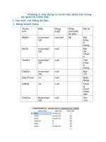
You will use several datasets throughout this tutorial. The
following tables provide descriptions of these datasets:
Coverage Description
Laterals Water laterals
INFO table Description
Owner.dat Parcel owners
Geodatabase Description
Montgomery Database that contains most of the
City of Montgomery data you will use
Feature datasets Description
Landbase Land base data
Water Water network data
Feature classes Description
Parcels Parcel polygons
Road_cl Road centerlines
Road_eop Road edge of pavement
RoadNames Annotation for Road_cl
Dimensions Dimension features
Distbmains Water distribution mains
DistmainDiam Annotation for Distbmains
Fittings Water network fittings
Gatevalves Water gate valves
Hydrants Water hydrants
Pipencasement Water pipe encasements
Prodwell1 Production wells (polygon)
Prodwell2 Production wells (point)
Pumpstat Pump stations
Sysvalves Water system valves
Tanks Water tanks
Transmains Water transmission mains
TransmainsDiam Annotation for Transmains
Trtplant Water treatment plant
Vaults Water meter vaults
Ch2.p65 01/18/2001, 3:50 PM16
QUICK-START TUTORIAL 17
The datasets were provided courtesy of The Water Works
& Sanitary Sewer Board of the City of Montgomery,
Alabama. They have been simplified by ESRI. The City of
Montgomery cannot guarantee the reliability or suitability of
this information. Original data was compiled from various
sources, and the spatial information may not be accurate.
This information may be updated, corrected, or otherwise
modified without notification.
Ch2.p65 01/18/2001, 3:50 PM17