báo cáo khoa học đề tài Ảnh hưởng của lở đất đến sử dụng đất giai đoạn 2000-2010 tại huyện Mai Châu, tỉnh Hòa Bình, Việt Nam
Bạn đang xem bản rút gọn của tài liệu. Xem và tải ngay bản đầy đủ của tài liệu tại đây (503.95 KB, 10 trang )
J. Sci. & Devel., Vol. 1
2
, No.
2
:
177
-
186
T
ạ
p chí Khoa h
ọ
c và Phát tri
ể
n 201
4
, t
ậ
p 1
2
, s
ố
2
:
177
-
186
www.hua.edu.vn
177
DAMAGE OF LANDSLIDE ON LAND USE FROM 2000 TO 2010
IN MAICHAU DISTRICT, HOABINH PROVINCE, VIETNAM
Đỗ Văn Nhạ
Faculty of Land Management, Hanoi University of Agriculture
Email:
Received date: 20.02.2014 Accepted date: 01.04.2014
Ảnh hưởng của lở đất đến sử dụng đất giai đoạn 2000-2010
tại huyện Mai Châu, tỉnh Hòa Bình, Việt Nam
TÓM TẮT
Lở đất sảy ra thường xuyên tại các vùng núi, nhất là vào mùa mưa tại vùng nhiệt đới như ở Việt Nam. Lở đất có
thể tác động nghiêm trọng đến việc sử dụng đất và hoạt động của người dân tại các vùng núi cao. Do đó, xác định
những tác hại của lở đất rất có ý nghĩa cho người sử dụng đất và các cấp chính quyền địa phương trong từng vùng
xác định từ đó đề xuất các loại hình sử dụng đất thích hợp nhất. Ảnh hưởng của lở đất được phân tích chi tiết trên
địa bàn huyện Mai Châu, tỉnh Hòa Bình dựa trên các phương pháp kinh tế. Kết quả cho thấy tác hại của lở đất ở đây
rất lớn cho sản xuất nông nghiệp, lâm nghiệp, khu dân cư và hệ thống đường giao thông, trong đó tác hại xảy ra lớn
nhất là đối với đường giao thông. Bên cạnh đó kết quả cũng chỉ ra những giai đoạn quan trọng của các loại hình sử
dụng đất cần có những giải pháp để tránh hoặc giảm thiểu những tác hại khi sảy ra lở đất. Nghiên cứu cũng mang
đến những cảnh báo cần thiết với người sử dụng đất ở các vùng đồi núi khác ở Việt Nam trong điều kiện biến đổi khí
hậu. Tuy nhiên, việc xác định hết những tác động của lở đất không đơn giản, cần có sự nghiên cứu ở nhiều lĩnh vực
khác như môi trường, con người ở hiện tại, tương lai và trong thời kỳ dài.
Từ khóa: Lở đất, ảnh hưởng của lở đất, sử dụng đất
ABSTRACT
Landslides happen frequently in moutainous region, especially in the rainy season in tropical zone like Vietnam.
The landslide can cause severe impact on land use and human activities in the highlands. Therefore, determining
the damage of landslide is meaningful for local land users and officials to propose the best land use types in the
specific area. Based on the economic methods, the damage of landslide was analysed specifically in Maichau
District, Hoabinh Province, Vietnam. The damage was very severe to agriculture, forest, residential land and road, of
which the damage ton road was the largest. Additionally, the results also indicated that the vital periods of land use
types need to have solutions to avoid or mitigate the damage of landslide. The research findings provide significant
warning to land users in other moutainous districts in Vietnam in the climate change era. However, identification of
different aspects of landslide damage is not an easy task and this needs to do research on other fields, such as
environment, human dimension, in the present, future and long term.
Keywords: Landslide, damage of landslide, land use.
1. INTRODUCTION
Landslides are triggered by events, such as:
earthquakes, rainfall and rapid snowmelt. They are
influenced by multiple factors: topography, the soil
and rock types, geologic fractures, etc. (Guzzetti,
2000; Sidle & Ochiai, 2006; Varnes, 1984).
According to Guzzetti et al. (1999),
landslides in a specific area do not only depend
on the natural condition, but also on land-uses
and other human activities. Neuhäuser and
Terhorst (2007) stated that the landslide
susceptibility assessment has become a major
Damage of landslide on land use from 2000 to 2010 in Maichau district, Hoabinh province, Vietnam
178
concern for authorities who are responsible for
regional land use planning and environmental
protection. To determine the damage of
landslide, a growing research effort has been
dealing with the creation of susceptibility or
hazard maps which describe the actual or
future threat from landslides (Lee & Dan, 2005;
Pradhan et al., 2008).
Recently, landslides have been among the
most hazardous natural disasters (Guzzetti et al.,
1999). The damages of landslides on resident
areas, infrastructures and even human casualties
have been increasing worldwide (Singhrog et al.,
2004 cited by Neuhäuser and Terhorst (2007)).
The impacts of landslides on socio-economic
development are potentially very large.
Landslides can damage urban (Chau et al., 2004)
or rural areas and they cause thousands of deaths
and injuries. Furthermore, landslides are able to
bury agricultural and forest land influencing local
production.
When determining the damage of disaster,
Richard (1995) stated that some of the damage
costs will grow with the economy and the
population, others will decline relatively, such
as: agricultural losses in developing countries,
and others will increase, particularly the
intangibles. However, the true costs of disasters
are not easy to identify and quantify because
they include total direct and indirect costs and
benefits. The damage of disasters can include
different aspects, such as: crop losses, repairs to
public infrastructure, property, and buildings.
Thus, most of the losses involve physical
damage to property, and disaster costs are
growing largely over the world because of
increasing societal vulnerability to disasters
(Downton & Pielke, 2005). Based on loss model
developed by Thieken et al. (2008), crop loss is
calculated as a percental deduction of the
perennial averaged yields. Therefore, crop
losses include loss of total investment and
ability to have income.
According to Sidle and Ochiai (2006: p9) and
Guzzetti (2000) landslides can be triggered by
many causes, such as land cover changes
promoted by overpopulation, economic
investment, depleted natural resources….
Additionally, landslides are related directly to
climate change, especially the increase of
temperature and rainfall worldwide (Coelho-
Netto et al., 2007; Lee et al., 2002; Westen et al.,
2006). The “Second National Strategy and
Action Plan for Disaster Mitigation and
Management in Vietnam from 2001 to 2020”
shows that about eight thousand people were
killed, 2.3 million tons of foods were destroyed,
and 6 million houses collapsed and washed away
by natural disasters in the decade of 1991 to
2000. The total estimated economic loss was
about USD 2.8 billion, i.e. 1.8-2.3% of the
national GDP or nearly USD 300 million yearly
(Van et al., 2006). Ahlheim et al. (2008) assumed
that affected households in northwest part of
Vietnam lose about 6% of their total annual
incomes as a consequence of landslide events.
According to statistical data in Maichau
District, nearly 90% of the population lived in
rural areas and 36.02% GDP was from
agricultural sector in 2010 (GSO Hoa Binh,
2010; GSO Mai Chau, 2010). The local people in
upland area, in general, and in Maichau, in
particular, had some limitations of education
and handcrafts. Thus, their food security and
living standards depend largely on agricultural-
forest activities (Cuong, 2005: p327). Damages
of natural disasters on agricultural activities
have been more significant because of regarding
directly to local people’s living. Therefore, to
determine the landslide and its damage is
important for not only local land users, but also
local officials to propose the suitable land use
types in the present and future. The research
objective was to determine the damage of actual
landslides from 2000 to 2010 in Maichau
District. The expective results can help the local
land users and officials to propose the solutions
for land use strategies land use planning for the
next period of development in the research area.
2. METHODS
2.1. Research area
Maichau District with its complicated
terrain was conveniently selected to carry out
Đỗ Văn Nhạ
179
the study. Located in the mountainous and
attractive region of the province with many
beautiful landscapes and traditional customs,
the district is considered as one of the beautiful
districts of Hoabinh Province and northwest
region of Vietnam. Moreover, the location of the
district is also a crucial bridge between Hanoi
and other provinces in the northwest region of
Vietnam (Anonymous, 2001: p14).
2.2. Research methods
Total Landslide Damage Cost (TLDC): A
number of landslide events happened in the
case study district in the past 10 years from
2000 to 2010. Some of these landslides
happened in areas used for agriculture,
infrastructures or residential areas ("villages").
Therefore, total damage of a landslide is defined
as Landslide Damage Cost (LDC). Accordingly,
the landslides have caused a certain total cost
(Total Landslide Damage Cost of the past 10
years: TLDC) which was determined by an
equation:
n
1i
i
LDCTLDC
(1)
where I is the individual landslide i (1-n);
LDC is the individual Landslide Damage Cost
To determine the Landside Damage Cost
caused by actual landslides on agriculture and
forest, the equation was used to analyze the
data which was based on the actual investment
and income of land users, as follows:
Landslide Damage Cost = Investment
Lost + Potential Net Income Lost (2)
Investment Lost were all investments (total
costs) in land use lost by a landslide which was
calculated for each household and averaged for
all households.
Potential Net Income Lost is understood as
a loss of ability to have net income. If landslides
did not happen, land users would have this net
income that was calculated for total lifetime of
crop. The potential net income was based on the
actual lifetime of crop before the happening of
landslide. It can be estimated as potentially
yield socially desirable outcomes in agricultural
activities (Fraser, 2009).
The investment period was actually long, in
particularly for forest, 7 years for Acacia, and
14 years for Bamboo. Therefore, present cash
flow with an interest rate for cost, revenue and
net income was used to determine the landslide
damage cost on forest.
The present cash flow of cost, revenue and
net income were conducted by the method
Future Value Analysis and Present Value
Analysis (Boardman et al., 2006: p135-136); The
equation was used to calculate:
t
vv
)i1(PF (3)
where: F
v
: Future value; P
v
: Present
value; i: Interest rate; t: Time (year)
Future value: The method compares what
the project will receive in the future if money
invests in the project with what it will receive in
the future if it invests in the best alternative.
The value plus interest is called the future
value, F
V
(Boardman et al., 2006: p132).
Present value: A switch from future value
to present value. Present Value Analysis
compares the current equivalent value of
investing in the project with the current
equivalent value of investing in the best
alternative project, given prevailing interest
rates. The current equivalent value of amount
that will be received in the future is called its
present value, P
V
(Boardman et al., 2006: p133).
Net Present Value (NPV) is calculated by
equation (Boardman et al., 2006: p137):
n
0t
t
t
n
0t
t
t
)i1(
C
)i1(
B
NPV
(4)
where: B: Benefit; C: Cost; t: Time (year);
i: Interest rate
The damage with above indicators on
agricultural land use types and forest was
calculated per ha, and then the calculation will
be applied in the total damaged area. Notably,
the damage on forest was calculated in each
year from the first to the last year of the forest
Damage of landslide on land use from 2000 to 2010 in Maichau district, Hoabinh province, Vietnam
180
rotation with the interest rate, after that the
damage was calculated with total actual
affected area from 2000 to 2010 in the research
area. For other land use types such as:
residential land and road, the damage was
calculated with each landslide event actually
happening from 2000 to 2010 in Maichau
District.
Household survey was conducted in the
research area with 65 farm households and 64
households for forest affected by actual
landslides from 2000 to 2010. The indicators are
the investment and productivity, revenue, and
slid area. In addition, 64 households with slid
residential land were investigated, including:
the value of slid house, slid area, and the price
of land.
3. RESULTS AND DISCUSSIONS
3.1. Damage of actual landslides to
agriculture (2000 – 2010)
To specify the damage of landslides in
Maichau, 65 households affected by the actual
122 landslide events from 2000 to 2010 were
investigated on investment, benefit and income.
In which 17, 41 and 7 households planted rice,
maize and cassava, respectively. Landslide
damage cost was calculated by equation (2). The
results are shown in table 1.
For agricultural crops, cost, revenue and net
income were calculated per ha. From household
data, the average of all households was
calculated. The actual “lifetime” of agricultural
crops was 3/4 total lifetime of these crops. The
actual “lifetime” is defined as the time from first
land preparation for seeding to the time point,
when the landslide happened.
Table 1 indicates that the total costs of rice
crop ha
-1
were VND18.8 mil. higher than those
of maize and cassava with VND15.4 mil. and
VND11.0 mil, respectively. The revenue of rice
crop, similarly, was the highest with VND25.3
mil. ha
-1
, followed by VND19.3 mil. and
VND12.5 mil. for maize and cassava,
respectively. Landslide damage cost on rice crop
was the largest with VND25.3 mil. ha
-1
. The
second and third were maize and cassava with
VND19.3 ml.ha
-1
and VND12.5 mil. ha
-1
,
respectively.
Table 1. Damage of actual landslides ha
-1
to agriculture (2000 – 2010)
Rice (n=17) Maize (n=41) Cassava (n=7)
Seed (VND million) 2.70 2.37 0.00
Plough land (VND million) 2.97 2.46 2.38
Fertilizer (VND million) 4.43 2.96 2.46
Pesticide (VND million) 2.27 0.81 0
Paid labour (VND million) 5.31 5.95 5.32
Other costs (VND million) 1.11 0.83 0.83
Total costs(VND million)(Investment Lost) 18.79 15.38 11.0
Productivity (ton/ha) 4.60 2.98 8.36
Price (million/ton) 5.5 6.5 1.5
Revenue (VND million) 25.30 19.34 12.54
Net income (VND million) 6.51 3.97 1.54
Potential net income lost (VND million) 6.51 3.97 1.54
Landslide Damage Cost (VND million) 25.30 19.34 12.54
Source: Own investigation and calculation
Đỗ Văn Nhạ
181
3.2. Damage of actual landslides to forest
(2000-2010)
To determine the Landslide Damage Cost
on forest from 2000 – 2010 in Maichau, 64 forest
planting households damaged by actual
landslides were investigated in detail. In which
4 and 60 households planted Acacia and
Bamboo, respectively. These households were
affected by 64 landslides in the research area.
For the affected Acacia and Bamboo plantings,
two different forest rotations need to be applied
in the calculation of potential net income: 7
years for Acacia and 14 year for Bamboo. The
landslides can happen in any of the 7 or 14
years of the rotation. Thus, present cash flow
was applied to carry out for each year with the
interest rate 9% per year.
The costs and revenue were investigated in
each year of forest cultivation. The costs
included seedling for the first year, fertilizer,
labour and others for all forest lifetime. The
forest revenue gained annually. However,
Acacia was harvested merely one time in the
last year of the rotation and to mainly supply
pulp industry. For bamboo, harvesting was
carried out during the dry season, from
November to following January from the 5
th
year of the rotation when the culm nutrient and
starch content are the lowest with the aim to
prevent culms being attacked by borers (Ha,
2010: p95). Bamboo shoot is a by-product of
bamboo, and it contributes largely to total
revenue.
Notably, landslides probably happen in
different periods of the forest rotation. The
happening can range from 1
st
year to 7
th
year
for Acacia and 1
st
year to 14
th
year for
bamboo. Therefore, the happening was
simulated by possibility from 1
st
to 7
th
year
for acacia and 1
st
to 14
th
year for bamboo.
Present cash flow of cost, revenue and
income of forest was calculated by equation
(3). Landslide Damage Cost on forest was
calculated by the equation (2).
Obviously, potential net income is understood
as an indispensable part of total damages to
forest. It would be able to have an income if
landslides did not happen. In fact, it was
calculated in each year of the rotation. In actual
investigated data, present cash flow was
calculated and is shown in the table 2 and table 3.
The results, synthesized in table 2, 3, and
fig 1, indicated that the landslide damage cost
changed quite differently between acacia and
bamboo. Indeed, for acacia, the damage raised
steadily from the year
+1
to the last year of the
rotation by roughly VND65.0 mil VND from
around VND14 mil.
Table 2. Damage of actual landslides on Acacia ha
-1
in Maichau District
Year
landslide
happened
Accumulated
Total costs
(Investment)
Total
revenue
Net
income
Present
cash flow
(Cost)
Present
cash flow
(Revenue)
Present cash
flow (Net
income)
Potential
Net Income
Landslide
Damage
Cost
Year
+1
9.56 0.00 -9.56 9.56 0.00 -9.56 4.32 13.88
Year
+2
12.20 0.00 -12.20 13.06 0.00 -13.06 9.42 22.47
Year
+3
13.57 0.00 -13.57 15.61 0.00 -15.61 15.40 31.00
Year
+4
14.95 0.00 -14.95 18.39 0.00 -18.39 22.37 40.76
Year
+5
16.32 0.00 -16.32 21.41 0.00 -21.41 30.49 51.90
Year
+6
17.70 0.00 -17.70 24.72 0.00 -24.72 39.88 64.59
Year
7
19.17 0.00 -19.17 28.42 0.00 -28.42 50.71 79.13
Source: Own investigation and calculation (Unit: VND million)
Damage of landslide on land use from 2000 to 2010 in Maichau district, Hoabinh province, Vietnam
182
Table 3. Damage of actual landslides on Bamboo ha
-1
in Maichau District
Year
landslide
happened
Accumulated
Total costs
(Investment)
Total
revenue
Net income
Present
cash flow
(Cost)
Present
cash flow
(Revenue)
Present cash
flow (Net
income)
Potential
Net Income
Landslide
Damage
Cost
Year
+1
6.48 0.00 -6.48 6.48 0.00 -6.48 3.72 10.19
Year
+2
8.62 0.00 -8.62 9.21 0.00 -9.21 8.10 17.31
Year
+3
10.73 0.00 -10.73 12.14 0.00 -12.14 13.24 25.38
Year
+4
12.51 0.00 -12.51 15.01 0.00 -15.01 19.25 34.26
Year
+5
14.29 0.00 -14.29 18.15 0.00 -18.15 26.23 39.13
Year
+6
16.07 5.57 -10.50 22.37 6.07 -16.29 33.96 50.25
Year
+7
17.86 13.83 -4.03 25.28 15.62 -9.67 43.62 53.29
Year
+8
19.64 27.56 7.92 29.34 31.99 2.65 54.34 51.69
Year
+9
21.42 45.51 24.09 33.77 54.43 20.67 66.63 45.97
Year
+10
23.20 63.85 40.65 38.59 79.33 40.74 80.70 39.96
Year
+11
25.04 82.20 57.16 43.89 106.47 62.57 96.76 34.19
Year
+12
26.87 102.15 75.27 49.68 137.79 88.11 115.06 26.95
Year
+13
28.78 121.29 92.52 56.06 171.06 115.01 135.86 20.85
Year
+14
30.74 140.44 109.70 63.07 207.33 144.26 159.48 15.22
Source: Own investigation and calculation (Unit: VND million)
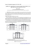
Fig. 1 Landslide damage cost ha
-1
on forest in Maichau District
10.19
17.31
25.38
34.26
39.13
50.25
53.29
51.69
45.97
39.96
34.19
26.95
20.85
15.22
13.88
22.47
31.00
40.76
51.90
64.59
79.13
0.00
10.00
20.00
30.00
40.00
50.00
60.00
70.00
80.00
90.00
1st 2nd 3rd 4th 5th 6th 7th 8th 9th 10th 11th 12th 13th 14th
Lifetime (Year)
Damage (VND million)
Bamboo Acacia
Đỗ Văn Nhạ
183
Mil. to VND79 mil., respectively. On the other
hand, the damage to bamboo was glanced as a
concave down parabola with the highest peak of
VND53.3 mil. at the year
+7
of the lifetime. The
downward went gradually into the year
+1
and
year
+14
with around VND10.0 mil. and VND15.0
mil., respectively. Thus, the economic income in
the year
+6
, year
+7
, year
+8
of bamboo rotation and
year
+7
of acacia rotation was the largest. As the
revenue was the largest and the investment was
the lowest in this period
The results assume that the year
+7
of acacia
rotation and the year
+6
, year
+7
, year
+8
of bamboo
rotation were important periods of forest
lifetime. If landslides happen in this time, total
losses will be the largest. The hypotheses
suggest that if proper types of land use are
proposed to prevent landslides in this time,
such damages could be lessened to as low as
possible. These results also have important
implications for land users and planners in land
use and land use policies in the present and
future development.
3.3. Damage of actual landslides to
residential area and peoples‘ lives (2000-
2010)
Land where the users are allowed to have one
of the following rights: to exchange, transfer,
lease, sub-lease, inherit, donate, mortgage land
use rights, provide guarantee or make capital
contribution with land use rights (article 61)
(Anonymous, 2003). In addition, population
growth is high (around >1%), indeed it is 1.05%
in 2010 (GSO, 2010). According to demographic
investigation, the average growth from 1999 to
2009 was 1.2% in comparison with 1.7% in the
previous period (Anonymous, 2010). Therefore,
the growth has caused a huge pressure to
expand the residential area.
Table 4. Damage of actual landslides on residential area (2000-2010)
Commune
ID of
Landslide
No of
destroyed
household
Damage on
house
(VND
million)
Affected
area (m
2
)
Price of
residential
land (1000
VND/m
2
)
Damage on
residential
land (VND
million)
Landslide
Damage
Cost (VND
million)
1 2 4 5 6 7 8=6x7 9=5+8
Pa Co 2 0 400 50 20.00 20.00
Pa Co 3 0 308 35 10.78 10.78
Hang Kia 4 1 100.00 300 30 9.00 109.00
Tan Son 7 0 300 55 16.50 16.50
Bao La 20 1 100.00 2,100 50 105.00 205.00
Bao La 23 1 80.00 400 45 18.00 98.00
Tan Mai 56 13 245.00 1,000 35 35.00 280.00
Phuc San 58 11 269.00 1,400 60 84.00 353.00
Dong Bang 61 3 300.00 700 55 38.50 338.50
Ba Khan 64 0 400 30 12.00 12.00
Tong Dau 66 1 30.00 1,200 60 72.00 102.00
Dong Bang 67 1 130.00 400 60 24.00 154.00
Dong Bang 68 3 370.00 320 60 19.20 389.20
Dong Bang 69 2 100.00 1,500 60 90.00 190.00
Tong Dau 76 5 125.00 1,200 110 132.00 257.00
Noong luong 101 0 400 30 12.00 12.00
Noong luong 104 0 800 30 24.00 24.00
Van Mai 116 12 580.00 1,200 70 84.00 664.00
Pu Bin 119 0 800 35 28.00 28.00
Total 19 54 2,429.00 15,128 833.98 3,262.98
Source: Own investigation and calculation
Damage of landslide on land use from 2000 to 2010 in Maichau district, Hoabinh province, Vietnam
184
In the research area, the calculation of
landslide damage cost on residential area
included damage on residential land and damage
on houses. Residential land has the highest value
in comparison with agricultural and forest land.
It is considered as the most valuable asset for
farmers. Therefore, the value of land should be
included in the landslide damage cost. The price
of residential land was stipulated by the
Maichau District’ People Committee Chairman
in Decision No 34/2011/QD-UBND. The price
ranged from VND30,000 to VND600,000 for
rural area and from VND 45,000 to
VND2,200,000for urban area.
Totally, 19 landslides that affected
residential area were investigated in 11
communes of the district. In fact, 63 households
were affected by landslides from 2000-2010. In
which, 54 houses of households were destroyed
by landslides. The household interview questions
included: How much residential area was
affected by landslides? Was the house destroyed
by landslides? How much money was lost by
landslides? The results are shown in table 4.
The results indicated that from 2000-2010,
residential area was affected by 19 landslides,
of which the damage of landslides to residential
land was nearly VND834 mil And the damage
on local people’s houses was estimated as very
high with VND2.429 mil. belonging to 54
households severely devastated by 12 landslides
in 7 communes in the research district. Total
landslide damage cost on residential area
including damage on residential land and
damage on houses was roughly VND3.263 mil.
that contributed largely to total landslide
damage cost from 2000 to 2010 in Maichau
District.
According to the investigation, 6 deaths
were caused by landslides from 2000 to 2010 in
the district. All killed individuals were from 30
to 35 years old. They could have worked in the
next 30 years, if landslides had not occurred.
Based on the economic point of view, this
“damage” can be approximated in monetary
terms using per capita GDP figures. The data in
table 5 showed that total damage of landslides
on deaths was VND541.14 mil.
3.4. Damage of actual landslides to road
system (2000-2010)
The investigation was carried out at the
Department of Transportation and at
communes. The statistical data on the damage
of actual landslides to the road system was
collected directly. Specifically, the length of the
road, the volume of removed land and the cost
of reconstruction of the road were surveyed in
the Department of Transportation. Finally, this
data were confirmed in the communes when the
field trip was conducted.
The results showed that a total of 1,275 m
of the road system was impacted by 10
landslides from 2000-2010. The landslide
damage cost on roads was calculated by the cost
of reconstruction these roads and the cost of
removal of land triggered by landslides. The
price to remove land and reconstruct the slid
roads was calculated based on the Decision No
2107/2007/QD-UBND stipulated by the people
committee chairman of Hoabinh Province. The
cost to remove land ranged from VND82,000 to
VND118,000 per m
3
depending on the rock
level in land. The cost of reconstruction was
roughly VND2.0 billion to VND2.5 billion per
km. The table 6 showed that the total landslide
damage cost on the road system was around
VND5.8 billion which also accounted
significantly for the total landslide damage cost
in the district.
Table 5. Damage of actual landslides on death (2000 – 2010)
Number of
death
GDP per capita
(Million VND)
Working duration
(year)
Interest rate
(%)
NPV (Total loss)
(Million VND)
6 8.0 30 9 541.14
Source: Own investigation and calculation
Đỗ Văn Nhạ
185
Table 6. Damage of actual landslides on road system (2000 – 2010)
Commune
ID of
landslide
Length of
Road (m)
Volume of
removed land
(m
3
)
Cost of movement
of land(VND
million)
Cost of
reconstruction
(VND million)
Landslide damage
cost (VND million)
Tan Son 10 150 3150 270.90 375.00 645.90
Cum Pheo 14 250 4500 531.00 625.00 1,156.00
Bao la 23 100 2800 240.80 250.00 490.80
Tan Dan 38 100 2000 164.00 250.00 414.00
Phuc San 60 200 4800 412.80 500.00 912.80
Ba Khan 65 50 900 106.20 125.00 231.20
Dong Bang 69 100 2700 232.20 250.00 482.20
Na Meo 83 150 3150 258.30 375.00 633.30
Thung Khe 97 125 2250 265.50 312.50 578.00
Van Mai 113 50 1050 123.90 125.00 248.90
Total 10 1,275 27,300 2,605.60 3,187.50 5,793.10
Source: Own investigation and calculation
According to equation (1) total landslide
damage cost was nearly VND13.42 billion
including damage to agriculture (VND1.15
billion ), forest (VND2.68 billion), residential
land (VND3.80 billion) and road (VND5.79
billion).
4. CONCLUSIONS
The impact of the landslides on the
district’s economy was quite large. Nearly 3% of
Maichau’s GDP in 2010 (VND422 billion (GSO
Mai Chau, 2010) ) was lost by landslides. With
annual GDP per capita VND8.0 mil. (GSO Mai
Chau, 2010), the landslides in the past 10 years
caused the loss of income of around 1,600
inhabitants or roughly 350 households. Local
people and the district’s economic situation
were, therefore, burdened substantially with
landslide damage cost. Indeed, total landslide
damage cost of 122 actual landslides from 2000
to 2010 was around VND13.42 billion and 6
deaths in the research district. Total damaged
area was 114.10 ha, including: 56.28 ha
agriculture, 55.48 ha forest, 1.51 ha residential
land and 0,83 ha road (1.3 km). Furthermore,
others damages of landslides likely affected the
living conditions of local people, such as:
transportation problems caused by road
damages or reduced or degraded water supply.
In terms of the landslide damage analysis,
the effect on the road system was very large.
Own data can be used here, however, as a
starting point for more detailed investigations.
For example, a future LUP may suggest to plant
forest trees on the high areas along to the roads
and build special constructions in the high
susceptibility areas to protect the road system.
At the level of detailed results, the
landslide damage analysis demonstrated that
the damage on rice crop was greatest, followed
by maize and cassava. For forest, if landslides
happen in the year
+7
for acacia and year
+6,+7,+8
for bamboo, the damage will be the largest. This
finding is meaningful for land users and
authorities to propose proper solutions to
protect forest trees in the vital periods of the
forest rotation and the annual crops.
REFERENCES
Ahlheim, Michael, Oliver Frör, Antonia Heinke, Alwin
Keil, Minh Duc Nguyen, & Van Dinh Pham.
(2008). Landslides in mountainous regions of
Northern Vietnam: Causes, protection strategies
and the assessment of economic losses
Hohenheimer Diskussionsbeiträge aus dem institut
Damage of landslide on land use from 2000 to 2010 in Maichau district, Hoabinh province, Vietnam
186
für volkswirtschafslehre der Universität
Hohenheim.
Anonymous. (2001). The report on land use planning of
Maichau District - Hoabinh Province: People's
committee of Maichau District.
Anonymous. (2003). The Vietnam Landlaw in 2003. In
Vietnam Government (Ed.).
Anonymous. (2010). General demographic
investigation 2009 in Vietnam Hanoi: Vietnamese
government.
Bickel, J. Eric, & Lee Lane. (2010). Clime change
engineering. In B. Lomborg (Ed.), Smart solutions
to climate change: Comparing Costs and Benefits
(pp. p9-61): Cambrige University Press.
Boardman, Anthony. E, David. H Greenberg, Aidan. R
Vining, & David. L Weimer. (2006). Cost - Benefit
Analysis: Concepts and Practice (Vol. Third
Edition): Pearson Prentice Hall. Upper Saddle
River, New Jersey 07458, USA.
Coelho-Netto, Ana Luiza, André S. Avelar, Manoel C.
Fernandes, & Willy A. Lacerda. (2007). Landslide
susceptibility in a mountainous geoecosystem,
Tijuca Massif, Rio de Janeiro: The role of
morphometric subdivision of the terrain.
Geomorphology, 87, p120-131.
Cuong, Pham Manh. (2005). Land-use change in the
Northwestern uplands of Vietnam. Georg-August
University, Goettingen, Germany.
Downton, Mary. W, & Roger A. Pielke. (2005). How
Accurate are Disaster Loss data? The case of U.S.
Flood Damage. Natural Hazards, 35, P211-228.
Fraser, Rob. (2009). Land Heterogeneity, Agricultural
Income Forgone and Environmental Benefit: An
Assessment of Incentive Compatibility Problems
in Environmental Stewardship Schemes. Journal of
Agricultural Economics, 60(1), P190-201.
GSO. (2010). National statistical data in 2010. National
statistical office.
GSO Hoa Binh. (2010). Statistical data in 2010.
Provincial statistical office of Hoa Binh.
GSO Mai Chau. (2010). Statistical data in 2010.
District statistical office of Mai Chau.
Guzzetti, Fausto. (2000). Landslide fatalities and the
evaluation of landslide risk in Italy. Engineering
Geology, 58, p89-107.
Guzzetti, Fausto, Alberto Carrara, Mauro Cardinali, &
Paola Reichenbach. (1999). Landslide hazard
evaluation: a review of current techniques and their
application in a multi-scale study, Central Italy.
Geomorphology, 31(1-4), 181-216.
Ha, Tran Viet. (2010). Growth and quality of
indigenous bamboo species in the mountainous
regions of Northern Vietnam. Georg-August-
Universität Göttingen, Goettingen.
Lee, Saro, Ueechan Chwae, & Kyungduck Min. (2002).
Landslide susceptibility mapping by correlation
between topography and geological structure: the
Janghung area, Korea. Geomorphology, 46, 149-
162.
Lee, Saro, & Nguyen Tu Dan. (2005). Probabilistic
landslide susceptibility mapping in the Lai Chau
province of Vietnam: focus on the relationship
between tectonic fractures and landslides. Environ
Geol, 48, 778-787.
Neuhäuser, Bettina , & Birgit Terhorst. (2007).
Landslide susceptibility assessment using
“weights-of-evidence” applied to a study area at
the Jurassic escarpment (SW-Germany).
Geomorphology, 86, 12-24.
Pradhan, Biswajeet, Shattri Mansor, Asro Lee, &
Manfred F. Buchroithner. (2008). Application of a
data mining model for landslide hazard mapping.
The international Archives of the Photogrammetry,
Remote Sensing and Spartial Information Sciences,
XXXVII (Part B8), p187-196.
Richard, S. J. Tol. (1995). The Damage Costs Of
Climate Change Toward More Comprehensive
Calculations. Environmental and Resource
Economics, 5, P353-374.
Sidle, Roy C, & Hirotaka Ochiai. (2006). Landslides:
Processes, Prediction, and Land Use: American
Geophysical Union, Washington DC, USA.
Thieken, A. H., V. Ackermann, F. Elmer, H. Kreibich,
B. Kuhlmann, U. Kunert, et al. (2008). Methods
for the evaluation of direct and indirect flood
losses: 4th International Symposium on Flood
Defence: Managing Flood Risk, Reliability and
Vulnerability. Toronto, Ontario, Canada
Van, Tran Tan, Le Viet Dung, Pham Hong Duc Phuoc,
& Le Van Du. (2006). Vetiver system for natural
disaster mitigation and environmental protection in
Vietnam - An overview Hanoi Vietnam: Ministry
of Natural Resources and Environment.
Varnes, David .J. (1984). Landslide hazard zonation: a
review of principles and practice. Paris: The
United Nations educational, scientific and cultural
organization.
Westen, C. J. van, T. W. J. van Asch, & R. Soeters.
(2006). Landslide hazard and risk zonation—why is it
still so difficult? Bull Eng Geol Env, 65, 167–184.