EM_1110-2-1100_App_A - Kỹ thuật công trình biển - App A
Bạn đang xem bản rút gọn của tài liệu. Xem và tải ngay bản đầy đủ của tài liệu tại đây (264.84 KB, 95 trang )
APPENDIX A
GLOSSARY OF COASTAL TERMINOLOGY
EM 1110-2-1100
(Change 1)
31 July 2003
Table of Contents
A-1. Glossary . . . . . . . . . . . . . . . . . . . . . . . . . . . . . . . . . . . . . . . . . . . . . . . . . . . . . . . . . . . . . . . . . . . A-1
A-2. Sources . . . . . . . . . . . . . . . . . . . . . . . . . . . . . . . . . . . . . . . . . . . . . . . . . . . . . . . . . . . . . . . . . . A-92
A-3. Acknowledgments . . . . . . . . . . . . . . . . . . . . . . . . . . . . . . . . . . . . . . . . . . . . . . . . . . . . . . . . . A-94
Appendix A Glossary of Coastal Terminology
A-i
EM 1110-2-1100 (Change 1)
31 Jul 03
Usage note: CAPITALIZATION within a definition indicates that the term is defined elsewhere in the
glossary. Figure numbers refer to the main text of the Coastal Engineering Manual.
A
ABRASION
The mechanical wearing away by rock material transported by wind or water
ABRASION PLATFORM
A rock or clay platform which has been worn by the processes of abrasion.
ACCELEROMETER
A device used in wave buoys for measuring acceleration.
ACCRETION
May be either natural or artificial. Natural accretion is the buildup of land, solely by the action of the forces of
nature, on a beach by deposition of water- or airborne material. Artificial accretion is a similar buildup of land by reason of
an act of man, such as the accretion formed by a GROIN, BREAKWATER, or beach fill deposited by mechanical means.
Also AGGRADATION.
ACTIVE MARGIN
A margin of a continental plate consisting of a continental shelf and slope, and an oceanic trench or basin.
ADJUSTABLE GROIN
A GROIN whose permeability can be changed, usually with gates or removable sections.
ADVANCE (of a beach)
(1) A continuing seaward movement of the shoreline. (2) A net seaward movement of the shoreline over a specified
time. Also PROGRESSION.
ADVECTION
Changes in a sea water property (salinity, temperature, oxygen content, etc.) that take place in the presence of
currents. Also, changes in atmospheric properties in the earth’s atmosphere.
AEOLIAN
See EOLIAN.
AGE, WAVE
The ratio of wave velocity to wind velocity (in wave forecasting theory).
AGGRADATION
See ACCRETION.
ALIGNMENT
The course along which the center line of a channel, canal or drain is located.
ALLUVIAL DEPOSITS
Detrital material which is transported by a river and deposited – usually temporarily – at points along the flood plain
of a river. Commonly composed of sands and gravels.
ALLUVIAL PLANE
A plain bordering a river, formed by the deposition of material eroded from areas of higher elevation.
ALLUVIUM
Soil (sand, mud, or similar detrital material) deposited by streams, or the deposits formed.
Appendix A Glossary of Coastal Terminology
A-1
EM 1110-2-1100 (Change 1)
31 Jul 03
ALONGSHORE
Parallel to and near the shoreline; LONGSHORE.
ALTIMETER
An instrument that determines its distance above a particular surface.
ALTIMETER, LASER
An instrument that determines altitude by measuring the length of time needed for a pulse of coherent light to travel
from the instrument to the surface and back, and multiplies half this time by the speed of light to get the straight-line distance
to the surface.
ALTIMETER, LIDAR
See ALTIMETER, LASER.
AMPLITUDE, WAVE
(1) The magnitude of the displacement of a wave from a mean value. An ocean wave has an amplitude equal to the
vertical distance from still-water level to wave crest. For a sinusoidal wave, the amplitude is one-half the wave height. (2)
The semirange of a constituent tide.
ANCHOR ICE
Spongy underwater ice formed on a submerged object or attached to the bottom of a shallow body of water which is
itself not frozen; syn. bottom ice
ANGLE OF REPOSE
The maximum slope (measured from the horizontal) at which soils and loose materials on the banks of canals, rivers
or embankments will stay stable.
ANISOTROPIC
Having properties that change with changing directions.
ANOXIC
Refers to an environment that contain little or no dissolved oxygen and hence little or no benthic marine life. These
conditions arise in some basins or fjords where physical circulation of seawater is limited.
ANTIDUNES
BED FORMS that occur in trains and are in phase with, and strongly interact with, gravity water-surface waves.
ANTINODE
See LOOP.
APRON
Layer of stone, concrete or other material to protect the toe of a structure.
AQUATIC MATERIAL PLACEMENT
Comprises all placement options under which the dredged material is submerged under water and remains
water-saturated after placement terminates.
AQUIFER
A geologic formation that is water-bearing, and which transmits water from one point in the formation to another.
ARCHIPELAGO
A sea that contains numerous islands; also the island group itself.
A-2
Appendix A Glossary of Coastal Terminology
EM 1110-2-1100 (Change 1)
31 Jul 03
ARMOR LAYER
Protective layer on a BREAKWATER or SEAWALL composed of armor units.
ARMOR UNIT or STONE
A relatively large quarrystone or concrete shape that is selected to fit specified geometric characteristics and
density. It is usually of nearly uniform size and usually large enough to require individual placement. In normal cases it is
used as primary wave protection and is placed in thicknesses of at least two units.
ARTIFICIAL NOURISHMENT
The process of replenishing a beach with material (usually sand) obtained from another location.
ASTRONOMICAL TIDE
The tidal levels and character which would result from gravitational effects, e.g. of the Earth, Sun and Moon,
without any atmospheric influences.
ATOLL
A ring-shaped coral REEF, often carrying low sand islands, enclosing a shallow LAGOON. The reef is surrounded
by deep water of the open sea.
ATTENUATION
(1) A lessening of the amplitude of a wave with distance from the origin. (2) The decrease of water-particle motion
with increasing depth. Particle motion resulting from surface oscillatory waves attenuates rapidly with depth, and practically
disappears at a depth equal to a surface wavelength.
AUTOCHTHONOUS
A term applied to shelves on which older shelf sediments are primarily being reworked by modern shelf processes.
AUTOMATIC TIDE GAGE
An instrument that automatically registers the rise and fall of the tide. In some instruments, the registration is
accomplished by printing the heights at regular intervals, in others by a continuous graph in which the height of the tide is
represented by the ordinates of the curve and the corresponding time by the abscissae.
AVULSION
(1) Rapid EROSION of the shore land by waves during a storm. (2) A sudden cutting off of land by flood, currents
or change in course of a body of water.
AWASH
Situated so that the top is intermittently washed by waves or tidal action. Condition of being exposed or just bare at
any stage of the tide between high water and chart datum.
Appendix A Glossary of Coastal Terminology
A-3
EM 1110-2-1100 (Change 1)
31 Jul 03
B
BACK BARRIER
Pertaining to the lagoon-marsh-tidal creek complex in the lee of a coastal barrier island, barrier spit, or baymouth
barrier.
BACKBEACH
See BACKSHORE.
BACKRUSH
The seaward return of the water following the uprush of the waves. For any given tide stage the point of farthest
return seaward of the backrush is known as the Limit of backrush or limit backwash.
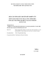
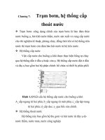
BACKSHORE
That zone of the shore or beach lying between the foreshore and the coastline comprising the BERM or BERMS
and acted upon by waves only during severe storms, especially when combined with exceptionally high water. Also
BACKBEACH. (See Figure A-1)
BACKWASH
(1) See BACKRUSH. (2) Water or waves thrown back by an obstruction such as a ship, BREAKWATER, or cliff.
BACKWASH RIPPLES
Low amplitude ripple marks formed on fine sand beaches by the Backwash of the waves.
BACKWATER CURVE
The longitudinal profile of the water surface in an open channel where the depth of flow has been increased by an
obstruction as a weir or a dam across the channel, by increase in channel roughness, by decrease in channel width or by a
decrease of the bed gradient
BANK
(1) The rising ground bordering a lake, river, or sea; or of a river or channel, for which it is designated as right or
left as the observer is facing downstream. (2) An elevation of the sea floor or large area, located on a continental (or island)
shelf and over which the depth is relatively shallow but sufficient for safe surface navigation (e.g., Georges Bank); a group of
shoals. (3) In its secondary sense, used only with a qualifying word such as “sandbank,” “gravelbank,” or “spoil bank,” a
shallow area consisting of shifting forms of silt, sand, mud, and gravel.
BAR
A submerged or emerged embankment of sand, gravel, or other unconsolidated material built on the sea floor in
shallow water by waves and currents. See BAYMOUTH BAR, CUSPATE BAR.
BARRIER BEACH
A bar essentially parallel to the shore, the crest of which is above normal high water level. Also called offshore
barrier and BARRIER ISLAND.
BARRIER FLAT
The flat area, often marshy and populated with low vegetation, on the bay or lagoon side of a barrier island
A-4
Appendix A Glossary of Coastal Terminology
EM 1110-2-1100 (Change 1)
31 Jul 03
a.
Typical Beach Profile
Coastline
Low Water Line
Shore
Coast
Toe of Shoreface
(Approx. Position)
Shoreface
Beach
Nearshore
--Upland Q M M M M M b M 。 ⦅ 」 ⦅ ォ ⦅ ウ ⦅ ィ ⦅ ッ M イ ・ M M M M M L M M M f M ッ ⦅ イ ⦅ ・ ⦅ ウ ⦅ ィ ⦅ ッ ⦅ イ ⦅ ・ ⦅ K M M M M M M M M M M M M M M M M セ L Offshore - Shore*
Bar • 1
Swash* Surf* Breaker
Breaker
I
1-Z>-o..n_et-_Z_o_n_e_-l-z...o_n.,e-1-,___s_u_rf
__z_o_n_e_*_-t_ _コ ⦅ ッ ⦅ ョ ⦅ ・ ⦅ ⦅ L セ
Dune
Crest
Transition
Zone
I
I
I
I
I
_ _ _ _ .L_ __ _
MHW
I
I
·.Berm.-":··
·:scarp.:. _..:....:
.·· ...
·:..·: .. ····
* -
セMZZ
Location and Width Vary
as Wove Conditions Change
':
. . .... •.·.. :' ·:. . . . N Z N セ . .. ::·.·... セ Z ...セ ᄋ :..-...·.. :.:.·. セ .ᄋ N セ ..Z -.ᄋ セ N ᄋ N ᄋ N ᄋ N ᄋ [ ᄋ N ᄋ セ セ
:
........ · .......
· · : . : . ..••• •• 1o
. · ·..:.
.; ......
セ セ セMセNZ
'
':
Trough and Bar
Position Variable
b.
Berm
Crest
.·
'.
セ
.: .
セ
Typical Bluff Profile
- - - - - - - - - - - - - - - - - - - - - - - - - - - - - - MHW
..
:·_.._..·
M
M
M
M
M
M
.·.:: ..····
M
M
___
..,..
. ·->.
Overwash
Fan
. ·.... ·'··:.
.. .:····
·..
. .. ...... .
M
c.
\:
M
M
M
M
M
M
M
M
M
M
M
M
M
M
M
M
M
M
m
セ
.. ,.
t イ セ オ ァ ィ .••.
....
..
:'::
..•'···
.,
:-
.... . :.··
_
Typical Overwash Profile
Berm.:
Crest ..' , ,. ·
MHW
..· .
. ·;.'
·.,
MLW
.Low·':,.·.:::
Tide
·. •·. Terrace
.....
_
....
. . . ...
·- ..
:...· ..
セ
Figure A-1. Definition of terms and features describing the coastal zone
Appendix A Glossary of Coastal Terminology
A-5
EM 1110-2-1100 (Change 1)
31 Jul 03
BARRIER ISLAND
A detached portion of a barrier beach between two inlets. It commonly has DUNES, vegetated areas, and swampy
terranes (see BARRIER FLAT) extending from the beach into the lagoon. Example: Outer Banks, North Carolina.
BARRIER LAGOON
A bay roughly parallel to the coast and separated from the open ocean by barrier islands. Also, the body of water
encircled by coral islands and REEFS, in which case it may be called an ATOLL lagoon.
BARRIER REEF
A coral REEF parallel to and separated from the coast by a lagoon that is too deep for coral growth. Generally,
barrier reefs follow the coasts for long distances and are cut through at irregular intervals by channels or passes. Example:
Great Barrier Reef, Queensland, Australia.
BARRIER SPIT
Similar to a BARRIER ISLAND, but connected to the mainland.
BASIN
A depressed area with no surface outlet, such as a lake basin or an enclosed sea.
BASIN, BOAT
A naturally or artificially enclosed or nearly enclosed harbor area for small craft.
BASTION
A massive groin, or projecting section of seawall normally constructed with its crest above water level.
BATHYMETRIC CHART
A topographic map of the bed of the ocean, with depths indicated by contours (isobaths) drawn at regular intervals.
BATHYMETRY
The measurement of water depths in oceans, seas, and lakes; also information derived from such measurements.
BAY
A recess in the shore or an inlet of a sea between two capes or headlands, not as large as a gulf but larger than a
cove. See also BIGHT, EMBAYMENT.
BAYMOUTH BAR
A bar extending partly or entirely across the mouth of a bay .
BAYOU
A minor sluggish waterway or estuarial creek, tributary to, or connecting, other streams or bodies of water, whose
course is usually through lowlands or swamps. Sometimes called SLOUGH. Term is commonly used in the southern United
States.
BEACH
The zone of unconsolidated material that extends landward from the low water line to the place where there is
marked change in material or physiographic form, or to the line of permanent vegetation (usually the effective limit of storm
waves). The seaward limit of a beach--unless otherwise specified--is the mean low water line. A beach includes foreshore
and backshore. (See Figure A-1) See also SHORE, SUSTAINABLE BEACH, and SELF-SUSTAINING BEACH, and
TIDELANDS.
BEACH ACCRETION
See ACCRETION.
A-6
Appendix A Glossary of Coastal Terminology
EM 1110-2-1100 (Change 1)
31 Jul 03
BEACH BERM
A nearly horizontal part of the beach or backshore formed by the deposit of material by wave action. Some beaches
have no berms, others have one or several. (See Figure A-1)
BEACH CREST
The point representing the limit of normal HIGH TIDE wave run-up (see BERM CREST)
BEACH CUSP
See CUSP.
BEACH EROSION
The carrying away of beach materials by wave action, tidal currents, littoral currents, or wind.
BEACH FACE
The section of the beach normally exposed to the action of the wave uprush. The FORESHORE of a BEACH. (Not
synonymous with SHOREFACE.)
BEACH FILL
Material placed on a beach to renourish eroding shores, usually pumped by dredge but sometimes delivered by
trucks.
BEACH HEAD
The cliff, dune or sea wall looming above the land ward limit of the active beach
BEACH MATERIAL
Granular sediments, usually sand or shingle moved by the sea.
BEACH NOURISHMENT
See BEACH FILL.
BEACH PLAN SHAPE
The shape of the beach in plan; usually shown as a contour line, combination of contour lines or recognizable
features such as beach crest and/or the still water line
BEACH PROFILE
A cross-section taken perpendicular to a given beach contour; the profile may include the face of a dune or sea wall,
extend over the backshore, across the foreshore, and seaward underwater into the NEARSHORE zone.
BEACH RIDGE
See RIDGE, BEACH.
BEACH SCARP
See SCARP, BEACH.
Appendix A Glossary of Coastal Terminology
A-7
EM 1110-2-1100 (Change 1)
31 Jul 03
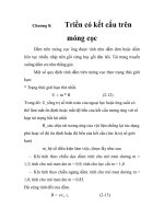
Table A-1
Beaufort Wind Scale
Beaufort
Number
Wind Speed
(knots)
WMO Description
0
<1
Calm
1
1-3
Light air
2
4-6
Light breeze
3
7 - 10
Gentle breeze
4
11 - 16
Moderate breeze
5
17 - 21
Fresh breeze
6
22 - 27
Strong breeze
7
28 - 33
Near gale
8
34 - 40
Gale
9
41 - 47
Strong Gale
10
48 - 55
Storm
11
56 - 63
Violent storm
12
$ 64
Hurricane
1
1
World Meteorological Organization, from
(28 Aug.
2001)
BEACH WIDTH
The horizontal dimension of the beach measured normal to the shoreline and landward of the higher-high tide line
(on oceanic coasts) or from the still water level (on lake coasts)
BEAUFORT SCALE
Classification of the force of the winds in accordance with a scale established by Rear-Admiral, Sir Francis
Beaufort in which the range of intensity varies in integers from 0 to 12, with a description of the state and behavior of a "wellconditioned man-of-war."
BED
The bottom of a watercourse, or any body of water.
BED FORMS
Any deviation from a flat bed that is readily detectable by eye and higher than the largest sediment size present in
the parent bed material; generated on the bed of an alluvial channel by the flow.
A-8
Appendix A Glossary of Coastal Terminology
EM 1110-2-1100 (Change 1)
31 Jul 03
BED LOAD
Sediment transport mode in which individual particles either roll or slide along the bed as a shallow, mobile layer a
few particle diameters deep, the part of the load that is not continuously in suspension.
BED PROTECTION
A (rock) structure on the bed in order to protect the underlying bed against erosion due to current and/or wave
action.
BED SHEAR STRESS
The way in which waves (or currents) transfer energy to the sea bed.
BEDDING PLANE
A surface parallel to the surface of deposition, which may or may not have a physical expression. The original
attitude of a bedding plane should not be assumed to have been horizontal.
BEDROCK
The solid rock that underlies gravel, soil, and other superficial material. Bedrock may be exposed at the surface (an
outcrop) or it may br buried under a few centimeters to thousands of meters of unconsolidated material.
BENCH
(1) A level or gently sloping erosion plane inclined seaward. (2) A nearly horizontal area at about the level of
maximum high water on the sea side of a dike.
BENCH MARK, TIDAL
A bench mark whose elevation has been determined with respect to MEAN SEA LEVEL at a nearby tide GAUGE;
the tidal bench mark is used as reference for that tide gauge.
BENCH MARK
A permanently fixed point of known elevation. A primary bench mark is one close to a tide station to which the
tide staff and tidal datum originally are referenced.
BENEFICIAL USE OF DREDGED MATERIAL
Placement or use of dredged material for some productive purpose. Examples: BEACH FILL or NEARSHORE
BERM construction.
BENEFITS
The asset value of a scheme, usually measured in terms of the cost of damages avoided by the scheme, or the
valuation of perceived amenity or environmental improvements
BENTHIC
Pertaining to the sub-aquatic bottom.
BENTHOS
Those animals who live on the sediments of the sea floor, including both mobile and non-mobile forms.
BERM
(1) On a beach: a nearly horizontal plateau on the beach face or backshore, formed by the deposition of beach
material by wave action or by means of a mechanical plant as part of a beach renourishment scheme. Some natural beaches
have no berm, others have several. (2) On a structure: a nearly horizontal area, often built to support or key-in an armor
layer.
BERM, BEACH
See BEACH BERM.
Appendix A Glossary of Coastal Terminology
A-9
EM 1110-2-1100 (Change 1)
31 Jul 03
BERM BREAKWATER
Rubble mound structure with horizontal berm of armor stones at about sea level, which is allowed to be (re)shaped
by the waves.
BERM CREST
The seaward limit of a BERM. Also called BERM EDGE. (See Figure A-1)
BIGHT
A bend in a coastline forming an open BAY. A BAY formed by such a bend.
BIOTURBATION
The disturbance of sediment bedding by the activities of burrowing organisms.
BIRDFOOT DELTA
A river DELTA formed by many levee-bordered DISTRIBUTARIES extending seaward and resembling in plan the
outstretched claws of a bird. Example: Mississippi River delta.
BLANKET (FOUNDATION or BEDDING)
A layer or layers of graded fine stones underlying a BREAKWATER, GROIN or rock embankment to prevent the
natural bed material from being washed away.
BLOWN SANDS
See EOLIAN SANDS.
BLOWOUT
A depression on the land surface caused by wind erosion.
BLUFF
A high, steep bank or cliff.
BOG
A wet, spongy, poorly drained area which is usually rich in very specialized plants, contains a high percentage of
organic remnants and residues and frequently is associated with a spring, seepage area, or other subsurface water source. A
bog sometimes represents the final stage of the natural processes of eutrophication by which lakes and other bodies of water
are very slowly transformed into land areas.
BOIL
An upward flow of water in a sandy formation due to an unbalanced hydrostatic pressure resulting from a rise in a
nearby stream, or from removing the overburden in making excavations.
BOLD COAST
A prominent landmass that rises steeply from the sea.
BORE
A very rapid rise of the tide in which the advancing water presents an abrupt front of considerable height. In
shallow estuaries where the range of tide is large, the high water is propagated inward faster than the low water because of the
greater depth at high water. If the high water overtakes the low water, an abrupt front is presented, with the high-water crest
finally falling forward as the tide continues to advance. Also EAGER.
BOTTOM (nature of)
The composition or character of the bed of an ocean or other body of water (e.g., clay, coral, gravel, mud, ooze,
pebbles, rock, shell, shingle, hard, or soft). (See Figure A-1)
A-10
Appendix A Glossary of Coastal Terminology
EM 1110-2-1100 (Change 1)
31 Jul 03
BOTTOM BOUNDARY LAYER
The lower portion of the water flow that experiences frictional retardation based on its proximity to the bed.
BOTTOMSET
One of the horizontal or gently inclined sediment layers deposited in front of the advancing forest beds of a delta.
BOULDER
A rounded rock more than 256 mm (10 inch) in diameter; larger than a cobblestone. See SOIL CLASSIFICATION.
BOUNDARY CONDITIONS
Environmental conditions, e.g. waves, currents, drifts, etc. used as boundary input to physical or numerical models
BOX GAGE
A tide GAUGE that is operated by a float in a long vertical box to which the tide is admitted through an opening in
the bottom. In the original type of box gauge the float supported a graduated rod which rose and fell with the tide.
BRAIDED RIVER
A river type with multiple channels separated by shoals, bars and islands
BREACHING
(1) Formation of a channel through a barrier spit or island by storm waves, tidal action, or river flow. Usually
occurs after a greater than normal flow, such as during a hurricane. (2) Failure of a dike allowing flooding.
BREAKER
A wave breaking on a shore, over a REEF, etc. Breakers may be classified into four types (See Figure II-4-1):
COLLAPSING--breaking occurs over lower half of wave, with minimal air pocket and usually no splash-up.
Bubbles and foam present.
PLUNGING--crest curls over air pocket; breaking is usually with a crash. Smooth splash-up usually follows.
SPILLING--bubbles and turbulent water spill down front face of wave. The upper 25 percent of the front face may
become vertical before breaking. Breaking generally occurs over quite a distance.
SURGING--wave peaks up, but bottom rushes forward from under wave, and wave slides up beach face with little
or no bubble production. Water surface remains almost plane except where ripples may be produced on the beachface during
runback.
BREAKER DEPTH
The still-water depth at the point where a wave breaks. Also called BREAKING DEPTH.
BREAKER INDEX
Ratio of breaking wave height to DEEPWATER wave height
BREAKER ZONE
The zone within which waves approaching the coastline commence breaking, typically in water depths of between 5
and 10 meters for ocean coasts, but sometimes in shallower water.
BREAKING
Reduction in wave energy and height in the surf zone due to limited water depth
BREAKWATER
A man-made structure protecting a shore area, harbor, anchorage, or basin from waves. A harbor work.
Appendix A Glossary of Coastal Terminology
A-11
EM 1110-2-1100 (Change 1)
31 Jul 03
BREASTWORK
Vertically-faced or steeply inclined structure usually built with timber and parallel to the shoreline, at or near the
beach crest, to resist erosion or mitigate against flooding.
BUFFER AREA
A parcel or strip of land that is designed and designated to permanently remain vegetated in an undisturbed and
natural condition to protect an adjacent aquatic or wetland site from upland impacts, to provide habitat for wildlife and to
afford limited public access.
BULKHEAD
A structure or partition to retain or prevent sliding of the land. A secondary purpose is to protect the UPLAND
against damage from wave action.
BULK DENSITY
Identical to apparent specific gravity, Ga = soil density ÷ density of water. “Apparent” means that the basis of
measurement is the total soil volume including voids, not just the individual soil particles.
BULL NOSE
Substantial lip or protuberance at the top of the seaward face of a wall, to deflect waves seaward.
BUOY
A float; especially a floating object moored to the bottom, to mark a channel, anchor, shoal rock, etc. Some
common types include: a nun or nut buoy is conical in shape; a can buoy is squat and cylindrical above water and conical
below water; a spar buoy is a vertical, slender spar anchored at one end; a bell buoy, bearing a bell, runs mechanically or by
the action of waves, usually marks shoals or rocks; a whistling buoy, similarly operated, marks shoals or channel entrances; a
dan buoy carries a pole with a flag or light on it.
BUOYANCY
The resultant of upward forces, exerted by the water on a submerged or floating body, equal to the weight of the
water displaced by this body.
BYPASSING, SAND
Hydraulic or mechanical movement of sand from the accreting updrift side to the eroding downdrift side of an inlet
or harbor entrance. The hydraulic movement may include natural movement as well as movement caused by man.
A-12
Appendix A Glossary of Coastal Terminology
EM 1110-2-1100 (Change 1)
31 Jul 03
C
CAISSON
Concrete box-type structure.
CALCAREOUS
Containing calcium carbonate (CaCO3), chiefly as the minerals calcite and aragonite. When applied to rock, it
implies that as much as 50 percent of the rock is carbonate (e.g., calcareous sand).
CALM
The condition of the water surface when there is no WIND WAVES or SWELL.
CANAL
An artificial watercourse cut through a land area for such uses as navigation and irrigation.
CANYON
A relatively narrow, deep depression with steep slopes, the bottom of which grades continuously downward. May
be underwater (submarine) or on land (SUBAERIAL).
CAPE
A land area jutting seaward from a continent or large island which prominently marks a change in, or interrupts
notably, the coastal trend; a prominent feature. Examples: Cape Cod, Massachusetts; Cape Hatteras, North Carolina.
CAPILLARY WAVE
A wave whose velocity of propagation is controlled primarily by the surface tension of the liquid in which the wave
is traveling. Water waves of length less than about 1 inch are considered capillary waves. Waves longer than 1 inch and
shorter than 2 inches are in an indeterminate zone between capillary and gravity waves. See RIPPLE.
CARTOGRAPHY
The science and art of making maps.
CATCHMENT AREA
The area which drains naturally to a particular point on a river, thus contributing to its natural discharge.
CAUSEWAY
A raised road across wet or marshy ground, or across water.
CAUSTIC
In refraction of waves, the name given to the curve to which adjacent orthogonals of waves refracted by a bottom
whose contour lines are curved, are tangents. The occurrence of a caustic always marks a region of crossed orthogonals and
high wave convergence.
CAY
See KEY.
CELERITY
Wave speed.
CENTRAL PRESSURE INDEX (CPI)
The estimated minimum barometric pressure in the eye (approximate center) of a particular hurricane. The CPI is
considered the most stable index to intensity of hurricane wind velocities in the periphery of the storm; the highest wind
speeds are associated with storms having the lowest CPI.
Appendix A Glossary of Coastal Terminology
A-13
EM 1110-2-1100 (Change 1)
31 Jul 03
CHANNEL
(1) A natural or artificial waterway of perceptible extent which either periodically or continuously contains moving
water, or which forms a connecting link between two bodies of water. (2) The part of a body of water deep enough to be used
for navigation through an area otherwise too shallow for navigation. (3) A large strait, as the English Channel. (4) The
deepest part of a stream, bay, or strait through which the main volume or current of water flows (see THALWEG).
CHANNEL CAPACITY
The maximum flow which a channel is capable of transmitting without its banks being overtopped.
CHANNEL-MOUTH BAR
A bar built where a stream enters a body of standing water, resulting from decreased flow velocity.
CHARACTERISTIC WAVE HEIGHT
See SIGNIFICANT WAVE HEIGHT.
CHART
A special-purpose map, esp. one designed for navigation such as a bathymetric chart.
CHART DATUM
The plane or level to which soundings (or elevations) or tide heights are referenced (usually LOW WATER
DATUM). The surface is called a tidal datum when referred to a certain phase of tide. To provide a safety factor for
navigation, some level lower than MEAN SEA LEVEL is generally selected for hydrographic charts, such as MEAN LOW
WATER or MEAN LOWER LOW WATER. See DATUM PLANE.
CHEMICAL WEATHERING
Disintegration of rocks and sediments by chemical alteration of the constituent minerals or of the cementing matrix.
It is caused by exposure, oxidation, temperature changes, and biological processes.
CHENIER
A long, narrow wooded beach ridge or sandy hummock forming roughly parallel to a prograding shore, usually
seaward of marsh and mud-flat deposits (as along the south coast of Louisiana)
CHOP
The short-crested waves that may spring up quickly in a moderate breeze, and which break easily at the crest. Also
WIND CHOP.
CHOPPY SEA
Short, rough waves tumbling with a short and quick motion. Short-crested waves that may spring up quickly in a
moderate breeze, and break easily at the crest.
CLAPOTIS
The French equivalent for a type of STANDING WAVE. In American usage it is usually associated with the
standing wave phenomenon caused by the reflection of a nonbreaking wave train from a structure with a face that is vertical
or nearly vertical. Full clapotis is one with 100 percent reflection of the incident wave; partial clapotis is one with less than
100 percent reflection.
CLASTIC ROCKS
Rocks built up of fragments which have been produced by weathering and erosion of pre-existing rocks and
minerals and, typically, transported mechanically to their point of deposition.
CLAY
A fine grained, plastic, sediment with a typical grain size less than 0.004 mm. Possesses electromagnetic properties
which bind the grains together to give a bulk strength or cohesion. See SOIL CLASSIFICATION.
A-14
Appendix A Glossary of Coastal Terminology
EM 1110-2-1100 (Change 1)
31 Jul 03
CLIFF
A high, steep face of rock; a precipice. See also SEA CLIFF.
CLIMATE
The characteristic weather of a region, particularly regarding temperature and precipitation, averaged over some
significant internal of time (years).
CLOSING LINE
The line dividing inland waters and the territorial sea at the mouth of a river, bay, or harbor.
CLOSURE DEPTH
The water depth beyond which repetitive profile or topographic surveys (collected over several years) do not detect
vertical sea bed changes, generally considered the seaward limit of littoral transport. The depth can be determined from
repeated cross-shore profile surveys or estimated using formulas based on wave statistics. Note that this does not imply the
lack of sediment motion beyond this depth.
CNOIDAL WAVE
A type of wave in shallow water (i.e., where the depth of water is less than 1/8 to 1/10 the wavelength). The surface
profile is expressed in terms of the Jacobian elliptic function cn u; hence the term cnoidal.
CO-TIDAL LINES
Lines which link all the points where TIDE is at the same stage (or phase) of its cycle.
COAST
(1) A strip of land of indefinite width (may be several kilometers) that extends from the SHORELINE inland to the
first major change in terrain features. (See Figure A-1.) (2) The part of a country regarded as near the coast.
COASTAL AREA
The land and sea area bordering the SHORELINE. (See Figure A-1)
COASTAL CURRENTS
(1) Those currents which flow roughly parallel to the shore and constitute a relatively uniform drift in the deeper
water adjacent to the surf zone. These currents may be tidal currents, transient, wind-driven currents, or currents associated
with the distribution of mass in local waters. (2) For navigational purposes, the term is used to designate a current in coastwise
shipping lanes where the tidal current is frequently rotary.
COASTAL DEFENSE
General term used to encompass both coast protection against erosion and sea defense against flooding.
COASTAL FORCING
The natural processes which drive coastal hydro- and morphodynamics (e.g.winds, waves, tides, etc).
COASTAL PLAIN
The plain composed of horizontal or gently sloping strata of clastic materials, generally representing a strip of sea
bottom that has emerged from the sea in recent geologic time. May extend inland many km.
COASTAL PROCESSES
Collective term covering the action of natural forces on the SHORELINE, and near shore seabed
COASTAL STRIP
A zone directly adjacent to the waterline, where only coast related activities take place. Usually this is a strip of
some 100 m wide. In this strip the coastal defense activities take place. In this strip often there are restrictions to land use.
Appendix A Glossary of Coastal Terminology
A-15
EM 1110-2-1100 (Change 1)
31 Jul 03
COASTAL ZONE
The transition zone where the land meets water, the region that is directly influenced by marine and lacustrine
hydrodynamic processes. Extends offshore to the continental shelf break and onshore to the first major change in topography
above the reach of major storm waves. On barrier coasts, includes the bays and LAGOONS between the BARRIER and the
mainland.
COASTAL ZONE MANAGEMENT
The integrated and general development of the coastal zone. Coastal Zone Management is not restricted to coastal
defense works, but includes also a development in economical, ecological and social terms. Coastline Management is a part of
Coastal Zone Management.
COAST LINE
The term used in the Submerged Lands Act to describe the low-water line and closing lines across the mouths of
inland water bodies.
COASTLINE
(1) Technically, the line that forms the boundary between the coast and the shore. (2) Commonly, the line that
forms the boundary between the land and the water, esp. the water of a sea or ocean. The SHORELINE. A more general
term than COAST LINE.
COBBLE (COBBLESTONE)
A rock fragment between 64 and 256 mm in diameter, usually rounded. See SOIL CLASSIFICATION.
COFFERDAM
A temporary watertight structure enclosing all or part of the construction area so that construction can proceed in
the dry.
COHESIVE SEDIMENT
Sediment containing significant proportion of clays, the electromagnetic properties of which cause the sediment to
bind together.
COLLOID
As a size term refers to particles smaller than 0.00024 mm, smaller than clay size.
COMBER
(1) A DEEPWATER wave whose crest is pushed forward by a strong wind; much larger than a whitecap. (2) A
long-period breaker.
COMPETENCE
The ability of a wind or water current to transport detritus, in terms of particle size rather than amount, measured as
the diameter of the largest particles.
COMPLEX SPIT
A large RECURVED SPIT with secondary spits developed at its end. Example: Sandy Hook, New Jersey.
CONFLUENCE
The junction of two or more river reaches or channels (the opposite of a bifurcation) .
CONSOLIDATION
The gradual, slow compression of a cohesive soil due to weight acting on it, which occurs as water is driven out of
the voids in the soil. Consolidation only occurs in clays or other soils of low permeability.
A-16
Appendix A Glossary of Coastal Terminology
EM 1110-2-1100 (Change 1)
31 Jul 03
CONTINENTAL SHELF
(1) The zone bordering a continent extending from the line of permanent immersion to the depth, usually about 100
m to 200 m, where there is a marked or rather steep descent toward the great depths of the ocean. (2) The area under active
littoral processes during the HOLOCENE period. (3) The region of the oceanic bottom that extends outward from the
shoreline with an average slope of less than 1:100, to a line where the gradient begins to exceed 1:40 (the CONTINENTAL
SLOPE).
CONTINENTAL SLOPE
The declivity from the offshore border of the CONTINENTAL SHELF to oceanic depths. It is characterized by a
marked increase in slope.
CONTOUR
A line on a map or chart representing points of equal elevation with relation to a DATUM. It is called an
ISOBATH when connecting points of equal depth below a datum. Also called DEPTH CONTOUR.
CONTROLLING DEPTH
The least depth in the navigable parts of a waterway, governing the maximum draft of vessels that can enter.
CONVERGENCE
(1) In refraction phenomena, the decreasing of the distance between orthogonals in the direction of wave travel.
Denotes an area of increasing wave height and energy concentration. (2) In wind-setup phenomena, the increase in setup
observed over that which would occur in an equivalent rectangular basin of uniform depth, caused by changes in planform or
depth; also the decrease in basin width or depth causing such increase in setup.
CORAL
(1) (Biology) Marine coelenterates (Madreporaria), solitary or colonial, which form a hard external covering of
calcium compounds or other materials. The corals which form large REEFS are limited to warm, shallow waters, while those
forming solitary, minute growths may be found in colder waters to great depths. (2) (Geology) The concretion of coral
polyps, composed almost wholly of calcium carbonate, forming reefs and tree-like and globular masses. May also include
calcareous algae and other organisms producing calcareous secretions, such as bryozoans and hydrozoans.
CORAL REEF
A coral-algal mound or ridge of in-place coral colonies and skeletal fragments, carbonate sand, and organicallysecreted calcium carbonate. A coral reef is built up around a wave-resistant framework, usually of older coral colonies.
CORE
(1) A cylindrical sample extracted from a beach or seabed to investigate the types and depths of sediment layers.
(2) An inner, often much less permeable portion of a BREAKWATER or BARRIER BEACH
CORIOLIS EFFECT
Force due to the Earth's rotation, capable of generating currents. It causes moving bodies to be deflected to the right
in the Northern Hemisphere and to the left in the Southern Hemisphere. The "force" is proportional to the speed and latitude
of the moving object. It is zero at the equator and maximum at the poles.
COVE
A small, sheltered recess in a COAST, often inside a larger EMBAYMENT.
COVER LAYER
The outer layer used in a rubble system as protection against external hydraulic loads
CREEK
(1) A stream, less predominant than a river, and generally tributary to a river. (2) A small tidal channel through a
coastal MARSH.
Appendix A Glossary of Coastal Terminology
A-17
EM 1110-2-1100 (Change 1)
31 Jul 03
CREEP
Very slow, continuous downslope movement of soil or debris.
CRENULATE
An indented or wavy shoreline beach form, with the regular seaward- pointing parts rounded rather than sharp, as in
the cuspate type.
CREST
Highest point on a beach face, BREAKWATER, or SEAWALL.
CREST LENGTH, WAVE
The length of a wave along its crest. Sometimes called CREST WIDTH.
CREST OF WAVE
(1) the highest part of a wave. (2) That part of the wave above still-water level. (See Figure II-1-4.)
CREST OF BERM
The seaward limit of a berm. Also called BERM EDGE. (See Figure A-1.)
CREST WIDTH, WAVE
See CREST LENGTH, WAVE.
CROSS-BEDDING
An arrangement of relatively thin layers of rock inclined at an angle to the more nearly horizontal BEDDING
PLANES of the larger rock unit. Also referred to as cross-stratification.
CROSS-SHORE
Perpendicular to the SHORELINE.
CROWN WALL
Concrete superstructure on a rubble mound.
CURRENT
(1) The flowing of water, or other liquid or gas. (2) That portion of a stream of water which is moving with a
velocity much greater than the average or in which the progress of the water is principally concentrated. (3) Ocean currents
can be classified in a number of different ways. Some important types include the following: (1) Periodic - due to the effect
of the tides; such Currents may be rotating rather than having a simple back and forth motion. The currents accompanying
tides are known as tidal currents; (2) Temporary - due to seasonal winds; (3) Permanent or ocean - constitute a part of the
general ocean circulation. The term DRIFT CURRENT is often applied to a slow broad movement of the oceanic water; (4)
Nearshore - caused principally by waves breaking along a shore.
CURRENT, COASTAL
One of the offshore currents flowing generally parallel to the shoreline in the deeper water beyond and near the surf
zone; these are not related genetically to waves and resulting surf, but may be related to tides, winds, or distribution of mass.
CURRENT, DRIFT
A broad, shallow, slow-moving ocean or lake current. Opposite of CURRENT, STREAM.
CURRENT, EBB
The tidal current away from shore or down a tidal stream. Usually associated with the decrease in the height of the
tide.
CURRENT, EDDY
See EDDY.
A-18
Appendix A Glossary of Coastal Terminology
EM 1110-2-1100 (Change 1)
31 Jul 03
CURRENT, FEEDER
Any of the parts of the nearshore current system that flow parallel to shore before converging and forming the neck
of the RIP CURRENT.
CURRENT, FLOOD
The tidal current toward shore or up a tidal stream. Usually associated with the increase in the height of the tide.
CURRENT, INSHORE
See INSHORE CURRENT.
CURRENT, LITTORAL
Any current in the littoral zone caused primarily by wave action; e.g., LONGSHORE CURRENT, RIP CURRENT.
See also CURRENT, NEARSHORE.
CURRENT, LONGSHORE
The littoral current in the breaker zone moving essentially parallel to the shore, usually generated by waves
breaking at an angle to the shoreline.
CURRENT METER
An instrument for measuring the velocity of a current
CURRENT, NEARSHORE
A current in the NEARSHORE ZONE. (See Figure A-1)
CURRENT, OFFSHORE
See OFFSHORE CURRENT.
CURRENT, PERIODIC
See CURRENT, TIDAL.
CURRENT, PERMANENT
See PERMANENT CURRENT.
CURRENT, RIP
See RIP CURRENT.
CURRENT, STREAM
A narrow, deep, and swift ocean current, as the Gulf Stream. CURRENT, DRIFT.
CURRENT SYSTEM, NEARSHORE
See NEARSHORE CURRENT SYSTEM.
CURRENT, TIDAL
The alternating horizontal movement of water associated with the rise and fall of the tide caused by the
astronomical tide-producing forces. Also CURRENT, PERIODIC. See also CURRENT, FLOOD and CURRENT, EBB.
CURRENT-REFRACTION
Process by which wave velocity, height, and direction are affected by a current
CUSP
One of a series of short ridges on the FORESHORE separated by crescent-shaped troughs spaced at more or less
regular intervals. Between these cusps are hollows. The cusps are spaced at somewhat uniform distances along beaches.
They represent a combination of constructive and destructive processes. Also BEACH CUSP. (See Figure III-2-23.)
Appendix A Glossary of Coastal Terminology
A-19
EM 1110-2-1100 (Change 1)
31 Jul 03
CUSPATE BAR
A crescent-shaped bar uniting with the shore at each end. It may be formed by a single spit growing from shore and
then turning back to again meet the shore, or by two spits growing from the shore and uniting to form a bar of sharply cuspate
form.
CUSPATE SPIT
The spit that forms in the lee of a shoal or offshore feature (BREAKWATER, island, rock outcrop) by waves that
are refracted and/or diffracted around the offshore feature. It may eventually grow into a TOMBOLO linking the feature to
the mainland.
CUTTERHEAD DREDGE
A hydraulic dredge that uses a rotating steel head consisting of hardened cutting blades and a backing ring to
dislodge bottom material. The head is mounted at the suction entrance of the hydraulic pipeline, and fluidized material is
picked up by suction and carried away through the pipe.
CYCLOIDAL WAVE
A steep, symmetrical wave whose crest forms an angle of 120 degrees and whose form is that of a cycloid. A
trochoidal wave of maximum steepness. See also TROCHOIDAL WAVE.
CYCLONE
A system of winds that rotates about a center of low atmospheric pressure. Rotation is clockwise in the Southern
Hemisphere and anti-clockwise in the Northern Hemisphere. In the Indian Ocean, the term refers to the powerful storms
called HURRICANES in the Atlantic.
A-20
Appendix A Glossary of Coastal Terminology
EM 1110-2-1100 (Change 1)
31 Jul 03
D
DAM
Structure built in rivers or estuaries, basically to separate water at both sides and/or to retain water at one side.
DATUM
Any permanent line, plane or surface used as a reference datum to which elevations are referred.
DATUM, CHART
See CHART DATUM.
DATUM, PLANE
The horizontal plane to which soundings, ground elevations, or water surface elevations are referred. Also
REFERENCE PLANE. The plane is called a TIDAL DATUM when defined by a certain phase of the tide. The following
datums are ordinarily used on hydrographic charts:
MEAN LOW WATER--Atlantic coast (U. S.), Argentina, Sweden, and Norway.
MEAN LOWER LOW WATER--Pacific coast (U. S.).
MEAN LOW WATER SPRINGS--United Kingdom, Germany, Italy, Brazil, and Chile.
LOW WATER DATUM--Great Lakes (U. S. and Canada).
LOWEST LOW WATER SPRINGS--Portugal.
LOW WATER INDIAN SPRINGS--India and Japan (See INDIAN TIDE PLANE).
LOWEST LOW WATER--France, Spain, and Greece.
A common datum used on United States topographic maps is MEAN SEA LEVEL. See also BENCH MARK.
DAVIDSON CURRENT
Deep-ocean boundary current off the west coast of the U.S. which brings warmer, saltier, low oxygen, high
phosphate equatorial type water from low to high latitudes.
DEBRIS LINE
A line near the limit of storm wave uprush marking the landward limit of debris deposits.
DECAY AREA
Area of relative CALM through which waves travel after emerging from the generating area.
DECAY DISTANCE
The distance waves travel after leaving the generating area (FETCH).
DECAY OF WAVES
The change waves undergo after they leave a generating area (FETCH) and pass through a calm, or region of lighter
winds. In the process of decay, the significant wave height decreases and the significant wavelength increases.
DEEP WATER
Water so deep that surface waves are little affected by the ocean bottom. Generally, water deeper than one-half the
surface wavelength is considered deep water. Compare SHALLOW WATER.
Appendix A Glossary of Coastal Terminology
A-21
EM 1110-2-1100 (Change 1)
31 Jul 03
DEEP WATER WAVES
A wave in water the depth of which is greater than one-half the WAVE LENGTH.
DEFLATION
The removal of loose material from a beach or other land surface by wind action.
DEGRADATION
The geologic process by means of which various parts of the surface of the earth are worn away and their general
level lowered, by the action of wind and water.
DELTA
(1) An ALLUVIAL DEPOSIT, usually triangular or semi-circular, at the mouth of a river or stream. The delta is
normally built up only where there is no tidal or current action capable of removing the sediment at the same rate as it is
deposited, and hence the delta builds forward from the coastline. (2) A TIDAL DELTA is a similar deposit at the mouth of a
tidal INLET, the result of TIDAL CURRENTS that flow in and out of the inlet.
DELTA PLAIN
The nearly-level surface composing the landward portion of a large DELTA.
DENSITY
Mass (in kg) per unit of volume of a substance; kg/m3. For pure water, the density is 1000 kg/m3, for seawater the
density is usually more. Density increases with increasing salinity, and decreases with increasing temperature. More
information can be found in "properties of seawater". For stone and sand, usually a density of 2600 kg/m3 is assumed.
Concrete is less dense, in the order of 2400 kg/m3. Some types of basalt may reach 2800 kg/m3.
For sand, including the voids, one may use 1600 kg/m3, while mud often has a density of 1100 - 1200 kg/m3.
DENSITY CURRENT
Phenomenon of relative flow within water due to difference in density. For example, the salt-water wedge is a
density current, as is a volcanic nuée ardente.
DENSITY STRATIFICATION
The lateral expansion of a sediment plume as it moves out of the distributary mouth, where salt and fresh water mix.
This is most likely to occur where the speed of the river flow is moderate to low and the distributary mouth is relatively deep.
DENSITY-DRIVEN CIRCULATION
Variations in salinity create variations in density in estuaries. These variations in density create horizontal pressure
gradients, which drive estuarine circulation.
DEPRESSION
A general term signifying any depressed or lower area in the ocean floor.
DEPTH
The vertical distance from a specified datum to the sea floor.
DEPTH CONTOUR
See CONTOUR, also ISOBATH.
DEPTH, CONTROLLING
See CONTROLLING DEPTH.
DEPTH FACTOR
See SHOALING COEFFICIENT.
A-22
Appendix A Glossary of Coastal Terminology
EM 1110-2-1100 (Change 1)
31 Jul 03
DEPTH OF BREAKING
The still-water depth at the point where the wave breaks. Also BREAKER DEPTH.
DERRICK STONE
See STONE, DERRICK.
DESIGN HURRICANE
See HYPOTHETICAL HURRICANE.
DESIGN STORM
A hypothetical extreme storm whose waves coastal protection structures will often be designed to withstand. The
severity of the storm (i.e. return period) is chosen in view of the acceptable level of risk of damage or failure. A DESIGN
STORM consists of a DESIGN WAVE condition, a design water level and a duration.
DESIGN WAVE
In the design of HARBORS, harbor works, etc., the type or types of waves selected as having the characteristics
against which protection is desired.
DESIGN WAVE CONDITION
Usually an extreme wave condition with a specified return period used in the design of coastal works.
DETACHED BREAKWATER
A BREAKWATER without any SUBAERIAL connection to the shore.
DETRITUS
Small fragments of rock which have been worn or broken away from a mass by the action of water or waves.
DIFFERENTIAL EROSION / WEATHERING
These features develop in rocks which have varying resistance to the agencies of erosion and/or weathering so that
parts of the rock are removed at greater rates than others. A typical example is the removal of soft beds from between harder
beds in a series of sedimentary rocks. The term may be applied to any size of feature, from small-scale ‘etching’ to the
regional development of hills and valleys controlled by hard and soft rocks.
DIFFRACTION (of water waves)
The phenomenon by which energy is transmitted laterally along a wave crest. When a part of a train of waves is
interrupted by a barrier, such as a BREAKWATER, the effect of diffraction is manifested by propagation of waves into the
sheltered region within the barrier's geometric shadow. (See Figure II-7-2)
DIFFRACTION COEFFICIENT
Ratio of diffracted wave height to DEEPWATER wave height.
DIFFUSION
The distributing or spreading-out of molecules, atoms, or substances into a vacuum, fluid, or porous medium so that
the concentration equalizes in all parts of the system
DIKE
Earth structure along sea or river in order to protect low lands from flooding by high water; dikes along rivers are
sometimes called LEVEES. Sometimes written as DYKE
DISCHARGE
The volume of water per unit of time flowing along a pipe or channel.
Appendix A Glossary of Coastal Terminology
A-23
EM 1110-2-1100 (Change 1)
31 Jul 03
DISPERSION
(1) Pattern of geographic distribution of individuals within a species. (2) Distortion of the shape of a seismic wave
train or ocean wave train because of variations of velocity with frequency.
DISTRIBUTARIES
Multiple branches of a river.
DITCH
A channel to convey water for irrigation or drainage.
DIURNAL
Having a period or cycle of approximately one TIDAL DAY.
DIURNAL CURRENT
The type of tidal current having only one FLOOD and one EBB period in the tidal day. A ROTARY CURRENT is
diurnal if it changes its direction through all points of the compass once each tidal day.
DIURNAL INEQUALITY
The difference in height of the two high waters or of the two low waters of each day. Also, the difference in velocity
between the two daily flood or EBB CURRENTS of each day.
DIURNAL TIDE
A tide with one high water and one low water in a tidal day. (See Figure II-5-16)
DIVERGENCE
(1) In refraction phenomena, the increasing of distance between orthogonals in the direction of wave travel.
Denotes an area of decreasing wave height and energy concentration. (2) In wind-setup phenomena, the decrease in setup
observed under that which would occur in an equivalent rectangular basin of uniform depth, caused by changes in planform or
depth. Also the increase in basin width or depth causing such decrease in setup.
DIVERGING WAVE
Waves that move obliquely out from a vessel’s sailing line. (See Figure II-7-40)
DIVERSION CHANNEL
A waterway used to divert water from its natural course. The term is generally applied to a temporary arrangement
e.g. to by-pass water around a dam site during construction.
DOCK
The slip or waterway between two piers, or cut into the land, for the reception of ships.
DOLPHIN
A cluster of piles.
DOWNDRIFT
The direction of predominant movement of littoral materials.
DOWNSTREAM
Along coasts with obliquely approaching waves there is a longshore (wave-driven) current. For this current, one
can define an upstream and a DOWNSTREAM direction. For example, on a beach with an orientation west-east, the sea is to
the north. Suppose the waves come from NW, then the current flows from West to East. Here, UPSTREAM is west of the
observer, and east is downstream of the observer.
A-24
Appendix A Glossary of Coastal Terminology