Desalination Trends and Technologies Part 3 ppt
Bạn đang xem bản rút gọn của tài liệu. Xem và tải ngay bản đầy đủ của tài liệu tại đây (7.23 MB, 25 trang )
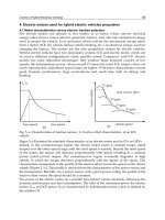
Water Desalination by Membrane Distillation
39
Karakulski, K.; Gryta, M. & Morawski, A. (2002). Membrane processes used for potable
water quality improvement,
Desalination, Vol. 145, No.1-3 (September 2002) 315–
319, ISSN 0011-9164
Karakulski, K. & Gryta, M. (2005). Water demineralisation by NF/MD integrated processes,
Desalination, Vol.177, No.1-3 (June 2005) 109–119, ISSN 0011-9164
Karakulski, K.; Gryta, M. & Sasim,M. (2006). Production of process water using integrated
membrane processes,
Chem. Pap., Vol.60, No.6 (November 2006) 416–421, ISSN
0366-6352
Khayet, M. & Matsuura, T. (2003). Application of surface modifying macromolecules for the
preparation of membranes for membrane distillation,
Desalination, Vol. 158, No.1-3,
(August 2003) 51–56, ISSN 0011-9164
Khayet, M.; Godino, M.P. & Mengual, J.I. (2004). Study of asymmetric polarization in direct
contact membrane distillation,
Sep. Sci. Technol., Vol. 39, No. 1 (January 2004) 125–
147, ISSN 0149-6395
Khayet, M.; Matsuura, T.;. Mengual, J.I. & Qtaishat, M. (2006). Design of novel direct contact
membrane distillation membranes,
Desalination, Vol.192, No.1-3 (May 2006) 105–
111, ISSN 0011-9164
Lawson, K.W. & Lloyd, D. R. (1997). Membrane distillation.
J. Membr. Sci., Vol.124, No.1
(February 1997) 1–25, ISNN 0376-7388
Lee, S. & Lee, Ch. (2000). Effect of operating conditions on CaSO
4
scale formation
mechanism in nanofiltration for water softening,
Water Res., Vol.34, No.15, (October
2000) 3854–3866, ISSN 0043-1354
Li, B. & Sirkar, K.K. (2004). Novel membrane and device for direct contact membrane
distillation-based desalination process,
Ind. Eng. Chem. Res., Vol. 43, No.17 (August
2004) 5300–5309, ISSN 0888-5885
Martínez-Díez, L. & Vázquez-González, M.I. (1999). Temperature and concentration
polarization in membrane distillation of aqueous salt solutions,
J. Membr. Sci., Vol.
156, No.2 (April 1999) 265–273, ISSN 0376-7388
Ortiz de Zárate, J.M.; Rincón, C. & Mengual, J.I. (1998) Concentration of bovine serum
albumin aqueous solutions by membrane distillation
, Sep. Sci. Technol., Vol. 33, No.,
283–296, ISSN 0149-6395
Schäfer, A.I.; Fane, A.G. & Wait, T.D., (Eds). (2005).
Nanofiltration: Principles and Application,
Elsevier, ISBN 1-85617-405-0, Oxford
Schneider, K.; Hölz, W. & Wollbeck, R. (1988). Membranes and modules for transmembrane
distillation,
J. Membr. Sci., Vol. 39, No.1 (October 1988) 25–42, ISSN 0376-7388
Singh, R (2006).
Hybrid Membrane Systems for Water Purification, Elsevier, ISBN 1-856-17442-5,
Kidlington
Smolders, K. & Franken, A.C.M. (1989). Terminology for membrane distillation,
Desalination,
Vol. 72, No.1-2 (April/May 1989) 249–262, ISSN: 0011-9164
Srisurichan, S.; Jiraratananon, R. & Fane, A.G. (2005). Humic acid fouling in the membrane
distillation,
Desalination, Vol.174, No.1 (April 2005) 63–72, ISSN 0011-9164
Srisurichan, S.; Jiraratananon, R. & Fane, A.G. (2006). Mass transfer mechanisms and
transport resistances in direct contact membrane distillation process,
J. Membr. Sci.,
Vol. 277, No.1-2 (June 2006) 186–194, ISSN 0376-7388
Desalination, Trends and Technologies
40
Teoh, M.M.; Bonyadi, S. & Chung, T.S. (2008). Investigation of different hollow fiber module
designs or flux enhancement in the membrane distillation process,
J. Membr. Sci.,
Vol. 311, No.1-2 (March 2008) 371–379, ISSN 0376-7388
Teoh, M.M. & Chung, T.S. (2009). Membrane distillation with hydrophobic macrovoid free
PVDF–PTFE hollow fiber membranes,
Sep. Purif. Technol., Vol.66, No.2 (April 2009),
229–236, ISSN 1383-5866
Tomaszewska, M. (1996). Preparation and properties of flat-sheet membranes from
poly(vinylidene fluoride) for membrane distillation,
Desalination, Vol.104, No.1-2
(April 1996) 1–11, ISSN 0011-9164
Tomaszewska, M. (1993). Concentration of the extraction fluid from sulfuric acid treatment
of phosphogypsum by membrane distillation,
J. Membr. Sci., Vol. 78, No.3 (April
1993) 277–282, ISSN 0376-7388
Tun, C.M.; Fane, A.G.; Matheickal, J.T. & Sheikholeslami, R. (2005) Membrane distillation
crystallization of concentrated salts-flux and crystal formation,
J. Membr. Sci.,
Vol.257, No.1-2 (July2005) 144–155, ISSN 0376-7388
Qu, D.; Wang, J.; Wang, L., Hou, D.; Lian, Z. & Wang, B. (2009). Integration of accelerated
precipitation softening with membrane distillation for high-recovery desalination
of primary reverse osmosis concentrate,
Sep. Purif. Technol., Vol.67, No.1 (May 2009)
21–25, ISSN 1383-5866
Wang, K.Y.; Chung, T.S. & Gryta, M. (2008). Hydrophobic PVDF hollow fiber membranes
with narrow pore size distribution and ultra-thin skin for the freshwater
production through membrane distillation,
Chem. Eng. Sci., Vol. 63, No.9 (May
2008) 2587–2594, ISSN 0009-2509
Yun, Y.; Ma, R.; Zhang, W.; Fane, A.G. & Li, J. (2006). Direct contact membrane distillation
mechanism for high concentration NaCl solutions,
Desalination, Vol.188, No.1-3
(February 2006) 251–262, ISSN 0011-9164
3
Desalination of Coastal Karst Springs
by Hydro-geologic, Hydro-technical
and Adaptable Methods
Marko Breznik and Franci Steinman
University of Ljubljana, Faculty of Civil and Geodetic Engineering,
Slovenia
1. Introduction
The karst landscape consists of rocks such as limestone, dolomite, gypsum and various salts
which are, to a greater or lesser extent, soluble in water, and through which underground
water flows. According to this, the latest definition of the karst, 10 % of the world's land
surface, and as much as 40 % of Slovenia's surface, is covered by carbonate karst rocks,
which are the only kind of karst rocks that are important from the point of view of the
exploitation of their water resources. On typical carbonate karst, only short lengths of rivers
flowing through karst poljes are to be found. Elsewhere, due to the fact that water flows
underground, the karst is a dry area, with a lack of drinking water; next to the sea, brackish
karst springs are found.
This paper is concerned with the successes and failures of engineering -works which have
attempted to improve natural conditions through the construction of various structures for
the desalination of brackish springs. The fact that many completed works have been
successful should encourage engineers to design and build new hydro-technical structures
in karst environments (Breznik, 1998).
In the Ice ages were the differences between the lowest mean temperatures of the cold
periods and the highest ones of the warm periods 5 degrees Celsius. These differences
between the lowest ones of the Ice ages and the present highest ones are 7 degrees Celsius.
During the last 30 years, 10 warmest were between 1990 and 2006. We are living probably in
the warmest period during the last 150.000 years (Rošker, 2007). The yearly air temperatures
in Ljubljana have increased by 1,7 degrees Celsius in the last 50 years (Kajfež-Bogataj, 2006).
Sixty years ago, we had to walk for 1km over the Triglav mountains glacier, after climbing
over the Triglav's north wall, 800 m high. This glacier has nearly melted till the present.
Precipitations have decreased from 1100 to 1000 mm/year in the Trieste town during last
100 years. Italian scientists believe that the Azores Island’s anticyclone with sunny weather
has extended towards the Mediterranean. Precipitations in the Portorož town have
decreased by 14%, during the last 50 years (Kajfež-Bogataj, 2006). An about 1000 km large
belt of severe drought hazards event extends along the southern Spain, Italy, Greece, Turkey
and northern Africa to Syria and Iraq.
Lučka Kajfež-Bogataj, Professor of the Ljubljana University and the Vice-chair of the
Working Group II: Impacts, Adaptation and Vulnerability of the Intergovernmental Panel
Desalination, Trends and Technologies
42
on Climate Change (IPCC), warns that the climate changes will continue and threaten the
world population with shortages of water, energy and food. The adaptive measures have to
be taken quickly. The proposed desalination of larger karstic coastal springs could provide
fresh water for drinking and irrigation (Breznik, 1998; Breznik & Steinman, 2008).
2. Exploitation of karst ground water in coastal areas. Theory with examples
2.1 Sea water intrusion
Brackish karst springs are a regular phenomenon of any seashore consisting of limestone or
dolomite. Fresh water from a calcareous karst aquifer is contaminated by the intrusion of sea
water, which renders spring water useless. The development of brackish springs, therefore,
is of great human and economic importance for areas which are short of fresh water. The
first developments were made by the ancient Phoenicians, who covered submarine springs
with lead funnels and fed fresh water into leather bags (Kohout, 1966).
2.2 Springs in karst aquifers of isotropic permeability
The porosity and ground water movements in an isotropically permeable karst aquifer, and in
an aquifer in granular sediments, are similar. The flow of ground water is of a diffused type.
The mechanism of contamination of fresh ground water with sea water in aquifers in sand and
gravel has been explained by Ghyben (1888), Herzberg (1901) and Hubbert (1940). Fresh water
floats on denser sea water. A 40 m high column of sea water exerts the same pressure at the
bottom as a fresh water column about 41 m high. This is known as the Ghyben-Herzberg law.
The plane that separates the fresh and sea water in the aquifer is called the interface and is at a
depth of about 40 times the height of the fresh water table above sea level.
In areas in which ground water flows towards the sea, some sea water mixes with flowing
fresh water and creates a zone-of-mixing some meters high, which replaces the interface. In
this zone, ground water is brackish, while above it is fresh water and beneath it unchanged
sea water. The mixing process is partly the result of diffusion, but mostly of hydraulic
mixing due to the different velocities of fresh and sea water. The thickness of the zone-of-
mixing depends on the velocity of ground water movement and the fluctuations of the sea.
Ghyben-Herzberg rules can be used for the calculation. Numerous small, brackish springs at
small heights of 0.1 to 1 m above or some meters below sea level are typical of such a
system. Relevant examples are the lower part of the Postire and Marina Stupin valleys in
Croatia and a coastal aquifer in karstic sandstone in Israel. This paper does not discuss such
aquifers (Breznik, 1998).
2.3 Springs in karst aquifers of anisotropic permeability
2.3.1 Principle, cases, theory
In the depths of the karst, ground water circulation tends to concentrate along a limited
number of well-karstified zones. This is demonstrated by the concentration of drainage in
the direction of a few large springs. The karst of the Central Dinaric Alps, with an area of
17,500 km
2
, has only 55 large springs. Each spring, with a discharge from 7 to 9 m
3
/s, drains
a surface of 320 km
2
(Komatina, 1968). A similar situation is found on the island of Crete.
Each of three separated karst regions, Dikti, Psiloritis and Lefka Ori, with areas of 150, 300
and 400 km
2
, is drained by a single large spring, with respective discharges of 2, 6 and 8
m
3
/s. The water collecting galleries, Postire II, Dubrava, Zaton, Gustirne and Blaž, all in
Croatia, have also shown a concentration of ground water circulation (Breznik, 1973; 1998).
Desalination of Coastal Karst Springs by Hydro-geologic, Hydro-technical and Adaptable Methods
43
In an anisotropic karst aquifer, water flows through veins. The form of the veins is not
defined: A vein can be a dissolution channel, a permeable fissured zone, a system of small
connected cavities, etc. In seeking its course, water erodes paths through the least resistant
rocks, so that the veins meander and ramify in many ways. Branching of vein or vein-
branching is a place where the primary vein of karst massif branches off into the upper vein
leading to the coastal spring and into the lower vein leading to the submarine estavelle. This
is the conduit type of ground water circulation in karst. The mechanism of contamination
with sea water, therefore, cannot be the same as in karst of isotropic permeability or in
grained sediments of uniform porosity and with a semi-laminar diffused type circulation of
ground water. In karst of anisotropic permeability, contamination occurs in the vein-
branchings. This contamination was first explained by Gjurašin (1943), and in detail by
Kuščer (1950), and Breznik (1973, 1978, 1990 and 1998), and Breznik & Steinman (2008).
In 1938, Prof. Gjurašin of Zagreb University developed a theory on the basis of the flow of
sea water into the Gurdić spring on the Adriatic coast, that the various specific weights of
sea and fresh water are the cause of the sea intruding into springs along the coast and
coastal karst aquifers. The conduction channel splits into a larger upper vein and smaller
lower vein, the mouth of which must be below sea level. Springs above sea level are only
contaminated in a case in which the following equation is fulfilled:
m
SV
hh
γγ
γ
−
⋅
>
where γ is the specific weight of fresh water, γ
m
is the specific weight of sea water, h
S
is the
depth of the vein-branching below sea level, h
V
is the height of the spring above sea level
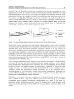
(Breznik, 1998). He also illustrated his theory pictorially for three hydrological conditions
(Fig. 1; Gjurašin, 1943).
Fig. 1. Outflows of the Gurdić spring in the southern Adriatic (Gjurašin, 1943).
Field observations were performed by I. Kuščer and colleagues in 1938-1940 and in 1947.
Seventy coastal and submarine springs, as well as thirty submarine estavelles, were
registered near a sawmill at Jurjevo in the Northern Adriatic (Fig. 2). During rainy periods,
all the springs deliver fresh water. The discharge of estavelle KEa is 1 m
3
/s at a depth of 9 m
below sea level. With the discharge decreasing in springtime, the outflow of estavelle KF
stops and sea water intrudes into the vein. Estavelle KE and the springs KC and KD are
contaminated by 700 mg/1 of CI
-
. In July, the springs KA and KB start delivering brackish
water. In dry summers, the estavelles KEb and Kola swallow about 0.1 m
3
/s of sea water,
and the salinity of springs KB increases to 9000 mg/1 of CI
-
. The estavelle Kola changes
Desalination, Trends and Technologies
44
Legend:
Q - Brackish coastal spring
o - Submarine spring
- - - - - Presumed underground
connection
r
1
-r
4
- Branchings of the
underground connections
KA-KD - Subgroups of springs with
similar characteristics
KE-KF - Submarine estavelles
Fig. 2. Jurjevo bay in Northern Adriatic (Kuščer, 1950).
from a spring to a swallow hole very quickly, in 1 to 2 days, and the salinity of the KB
springs also increases quickly. After the autumn rains and throughout the winter, all the
springs and estavelles discharge fresh water (Kuščer, 1950).
A tracer test with 300 g of fluoresceine was performed on July 30th, 1947. The tracer was
poured into the strongest submarine swallowhole, KEa. Colored water appeared after 5
hours in the springs KB, reached the highest concentration after 1 hour, and thereupon
slowly decreased. After 6.5 hours, spring KA was also colored by a 2 to 3 times weaker
concentration. Kuščer (Kuščer, 1950; Kuščer et al., 1962) indicates in his figure the estimated
position of the veins and their important branchings. These field observations confirmed the
type of contamination in vein-branchings. This scheme of sea water intrusion into a system
of karst conduits is explained on a simplified section with the smallest number of necessary
veins (Fig. 3).
Breznik examined the coastal springs and the estavelles in 40 karst places in the former
Yugoslavia, Greece and Turkey since 1956 (Fig. 4).
Desalination of Coastal Karst Springs by Hydro-geologic, Hydro-technical and Adaptable Methods
45
Fig. 3. Coastal spring of conduit type flow in karst aquifer (Kuščer, 1950).
Legend:
1 BROJNICA
2 SEČOVLJE
3 BLAŽ
4 KOROMAČNO
5 JURJEVO PRI SENJU
6 BOKANJAČKO BLATO – BADNJINE
7 VRILO
8 DUBRAVA
9 KOVČA – ZATON
10 LITNO
11 MARINA – STUPIN
12 GUSTIRNA
13 ZALIV POLJICE
14 PANTAN
15 VRULJA NA KAŠTELANSKEM ZALIVU
16 VRULJA pri kraju D.BRELA
17 POSTIRE
18 JELSA
19 KORITA
20 PIŠTICA
21 ŽRNOVICA
22 BILAN
23 TRPANJ
24 ŽULJANA
25 MOJDEŽ
26 OPAČICA
27 MORINJSKI IZVIRI
28 GURDIĆ, ŠKURDA
Fig. 4. Investigated karstic coastal springs along the eastern Adriatic coast (Breznik, 1973).
Fresh water from the karst massif is drained through the primary vein. This vein branches
off into the lower vein, connected with the sea, and into the upper vein, leading to the
spring. The present lower veins were formed in past geological periods by fresh water
flowing towards the sea at a lower level, and were primary veins in these periods. Sea water
later drowned them, either due to tectonic subsidence of the massifs in the Tertiary to
Holocene periods, or due to the melting of Pleistocene ice. The level of the Mediterranean
Sea in the Pleistocene period was initially 23 m higher, and then 120 m lower than at present
Desalination, Trends and Technologies
46
(Fig. 13). Karst water formed new channels to the actual sea surface, and these are the
present upper veins and springs (Breznik, 1998).
All the changes in the direction of flow and salinities are shown in Figs. 7 and 8, whether
there is fresh or brackish water in the same coastal spring or submarine estavelle, with either
a fresh water outflow or sea water intrusion, are determined in the vein-branchings, and
depend on the pressure of water in the veins forming the vein-branching. The piezometric
head and density of water in each vein determine the pressure. In rainy periods, the head of
water in the primary vein is high, and fresh water flows out of the lower vein as a
submarine spring forming characteristic 'wheels' on the sea surface, and out of the upper
vein as a fresh water coastal spring. In a dry period, the karst massif is drained and the
piezometric head in the primary vein subsides. An equal or slightly higher pressure of sea
water in the lower vein enables intrusion of sea water into the vein-branching. Brackish
water flows through the upper vein to the spring. The energy for this flow pattern is derived
from the fresh water head in the karst massif. Some submarine or coastal springs stop
flowing in dry periods, since the fresh water head cannot counterbalance the sea water
pressure. In such cases, the vein-branching and the lower part of the primary vein are
flooded with sea water. This happens first in deeper vein-branchings (Figs. 5 and 7; Breznik,
1973; 1989; and 1998). Notations used in following figures and equations are shown in Fig. 5.
Legend:
m
0
- Sea
gm - Sea level
i - Coastal spring – brackish water
v - Primary vein with fresh water
r - Branching of veins
s - Upper vein – brackish water
m - Lower vein – sea water
m
min
- Lowest point of lower vein
u - Mouth of the lower vein
h - Height above some reference level
ρ
v
- Density of fresh water
ρ
m
- Density of sea water
2 - Reference level
3 - Piezometric head line of the primary
and upper veins
4 - Piezometric head line of the lower
vein
5 - Energy head line of the primary and
upper veins
6 - Energy head line of the lower vein
3-6 - All the heads are expressed through
the head of fresh water
Fig. 5. Scheme of veins in the conduit type karst aquifer of a coastal spring (Breznik, 1973).
The pressure at the right side of the vein-branching is expressed by equation (1):
()
2
0
2
m
mr m m m
v
pp h h Tg fQ
g
ρ
⎛⎞
′
=+ −− − =
⎜⎟
⎜⎟
⎝⎠
(1)
and the pressure at the left side by equation (2):
()
2
0
2
r
ir s s s
v
p
phh Tg fQ
g
ρ
⎛⎞
′′
=+ −− + =
⎜⎟
⎜⎟
⎝⎠
(2)
Desalination of Coastal Karst Springs by Hydro-geologic, Hydro-technical and Adaptable Methods
47
Sea water can penetrate into a vein-branching if the pressure in the lower vein exceeds that
in the upper one. In inequation (3) Breznik (1973) states this requirement:
()
()
22
2
mmmssssmm
ir im
ms ms ms
TTv v
hh hh
g
ρ
ρρ ρ ρ
ρρ ρρ ρρ
+−
−> ⋅ − + −
−−−
(3)
All the denominators in the right part of the inequation are differences in densities. The first
numerator is the height of the spring above sea level, the second the sum of the head losses
in the upper and lower veins, and the third the difference of the velocity heads in the two
veins in the vein-branching.
There are certainly very few springs with only three veins, as in Fig. 5 which explains the
mechanism of contamination. Many pairs of primary and lower veins, with branchings at
different depths, must be expected for a single spring. This might explain the progressive
contamination observed in the Almyros Irakliou spring in Greece (Fig. 6; Ré, 1968 in
Breznik, 1973).
Legend:
Q
v
+ Q
m
- Total discharge
Cl
-
- Salinity in mg/l Cl
-
h
i
–h
m
- Water level of the upper spring
in meters above sea level
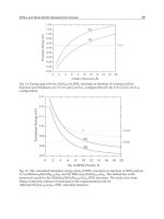
Fig. 6. Almyros Irakliou spring in Greece. Relation between discharge, water level and
salinity (Ré, 1968, published in Breznik, 1973).
In rainy periods and during the melting of snow in 2500 high Psiloritis massif, spring water
is fresh, with about 50 mg/l of Cl
-
at discharges above 12,5 m
3
/s. The relation between the
discharge and progressive salinity is a curve for discharges from 12.5 to 9 m
3
/s, and a
straight line for discharges below 9 m
3
/s. We can assume that at a discharge of 12,5 m
3
/s,
the deepest vein-branching starts to swallow some sea water. Shallower vein-branchings
start swallowing sea water when the discharge decreases to 9 m
3
/s. With smaller
discharges, all the vein-branchings swallow sea water. The Almyros spring must have one
upper vein, a long lower vein that divides into several channels at its end, some very deep
Legend:
Q
v
+ Q
m
- Total discharge
Cl
-
- Salinity in mg /l Cl
-
h
i
–h
m
- Water level of the upper spring
in meters above sea level
Desalination, Trends and Technologies
48
vein-branchings at different depths, and one or several primary veins connected with
different vein-branchings. The above system requires a conduit type flow pattern. Many
drowned karst channels connected in many directions are a characteristic of a diffused flow
pattern that cannot explain the very high level of the Almyros spring in 1977 and 1987
during tests with a spring level by a 1976 dam raised to 10 m ASL.
2.3.2 Equilibrium plane
Many karst springs are fresh during high discharges. When the discharge decreases,
contamination begins. Let us suppose the discharge just before the beginning of the
contamination is an equilibrium discharge Qeq. The lower vein is already filled with sea
water which has not yet penetrated into the vein-branching. There are no losses of fresh
water through the lower vein either. Hence
()
() ()
eq
2
s
eqs
2
s
s
sm
s
mi
sm
m
ri
mvs
m
2
m
mm
Qf
g2
v
,QfT
g2
v
Thhhh
028,1,0,1,0
g2
v
,0T,0Q
==
⎟
⎟
⎠
⎞
⎜
⎜
⎝
⎛
−⋅
ρ−ρ
ρ
+−⋅
ρ−ρ
ρ
=−
=ρ=ρ=ρ=
ρ
==
(4)
An equilibrium point in a karst vein filled with fresh water at one side, and with sea water
at the other, is the point at which the pressure of sea water is equal to that of fresh water. In
a karst aquifer of anisotropic permeability, an equilibrium plane is an interrupted plane that
connects all the equilibrium points in the veins. It can be detected only in the veins in which
it exists, and is found in very few boreholes (Breznik, 1973).
In a karst aquifer of isotropic permeability, or in an aquifer in granular soil, the sea water
zone is separated from the fresh water zone by an interface, or a zone-of-mixing. The
interface and the zone-of-mixing are continuous planes and can be detected in all boreholes
in the area. The difference between an interface and an equilibrium plane is similar to the
difference between the ground water table of a phreatic aquifer and the piezometric surface
of a confined one. The first can be detected in any borehole in the area, while the second
only in boreholes which have penetrated into the confined aquifer.
The elevation of the equilibrium plane changes in accordance with the elevation of the
piezometric surface of fresh water. In rainy periods, the piezometric surface of fresh water is
in a high position and the equilibrium plane in a low one. Fresh water flows out of the lower
vein as a submarine spring and out of the upper vein as a coastal spring. In this period, the
equilibrium plane is below the vein-branching and below the lower vein (Fig. 7, Phase A).
During the decline of the discharge, the piezometric surface of fresh water subsides and the
equilibrium plane consequently rises (Phase B). When the equilibrium plane crosses the
vein-branching, sea water from the lower vein intrudes into the vein-branching (Phase C).
Brackish water fills the upper vein and flows out of the coastal spring. In the dry period, the
piezometric surface in the karst massif continues to subside and the equilibrium plane in the
coastal zone rises. When the equilibrium plane has risen above the vein-branching and
crossed its primary vein, the outflow of fresh water through this vein-branching is blocked
(Phase D). Fresh water drained from the karst massif flows through higher vein-branchings
Desalination of Coastal Karst Springs by Hydro-geologic, Hydro-technical and Adaptable Methods
49
and is there contaminated. On the surface, we observe these phenomena in dry periods as a
decrease in discharge of all springs, some coastal springs dry out, all submarine springs stop
flowing, all submarine estavelles start swallowing sea water, and all springs deliver brackish
water (Breznik, 1989; 1998).
Fig. 7. Coastal spring with a siphon-like lower vein in a karst conduit flow aquifer, pi -
piezometric surface, eq - equilibrium plane. Four Flow: Salinity regimes (Breznik, 1989;
1998).
Heavy rains period
Dry period Very dry period
Fig. 8. Coastal spring with a rising lower vein in a karst conduit flow aquifer. Three Flow:
Salinity regimes (Breznik, 1989; 1998).
There are certainly very few springs with only 3 veins. Many pairs of primary and lower
veins, with the branchings of different depth, must be expected for a single spring. This
explains the progressive contamination observed in the Almyros spring (Fig. 6).
2.3.3 The case of the 'Sea mills' on Kefalonia Island
Sea water flowing into swallow holes of the 'Sea mills' on Kefalonia Island in Greece was
marked with 100 kg of uranine in 1963. The total inflow of sea water was about 1.7 m
3
/s and
Desalination, Trends and Technologies
50
the brackish outflow of the Sami springs about 20 m
3
/s. The brackish water of these springs
contained from 10 to 12% sea water. The tracer reappeared after 16 to 23 days.
The distance between the mills and the Sami springs being 15 km, the mean velocity of
tracer movement was 1 cm/s (Fig. 9). Glanz (1965) was of the opinion that this sea water
intrusion of 1.7 m
3
/s could not be ascribed to a Venturi-tube suction effect, because such an
arrangement, together with the simultaneous dissolution of calceros Venturi pumps, would
be too complex to resist under natural conditions. He explained the inflow of sea water by a
natural injector effect of fresh karst water submersed in sea water, working on the principle
of a water jet pump. A physical model supported that explanation (Fig. 10, Glanz, 1965; Fig.
11, Maurin, 1982). The phenomenon of the 'Sea mills' could be more easily explained by
mixing in a deep vein-branching on the different densities principle (Breznik, 1998; Fig. 12,
Breznik & Steinman, 2008).
Fig. 9. Kefalonia Island in Greece. Ponor of sea water near Argostolion (Glanz, 1965).
Many terrain observations talk against the hydro-dynamic method of infusion. A flow of sea
water has been noted in summer in the lower part of the source channel of the Port Miou
springs in France. Even the construction of underground desalination barriers in the spring
was not entirely successful, since source water still contained around 4000 mg/l CI. Further
development of the springs was then abandoned.
A similar phenomenon, i.e. a powerful inflow of sea water into the estavelle on the floor of
the gulf of Bali, and thus into the coastal karst aquifer, was observed in the summer of 1991
and the outflow in October 1970 and May 1983 on the island of Crete (Fig. 18).
All the above springs have fresh water in rainy periods and cannot have been contaminated
by a hydrodynamic effect, which should be greatest at high discharges. These springs are
contaminated in the vein-branchings in conduit flow aquifers because of different densities
Desalination of Coastal Karst Springs by Hydro-geologic, Hydro-technical and Adaptable Methods
51
of sea and fresh water. The vein-branchings can be deep in coastal karst aquifers, which is
partially a result of the 120 m lower sea level in the Pleistocene period (Fig. 13) and partially
the effect of inflow of sea water into deep syphons (Figs. 22 and 23).
Fig. 10. “Sea water mill” on Kefalonia Island in Greece (Glanz, 1965).
Fig. 11. Scheme of hydro-geological water circulation in the karstic rock mass of Kefalonia
Island (Maurin, 1982).
Fig. 12. “Sea water mill” on Kefalonia Island in Greece, explained by the different densities
principle (Breznik & Steinman, 2008).
The consequence of deep vein-branching is high salt water contamination in dry periods, of
springs such as Almyros Irakliou 10 m above sea level, Kournas lake 17 m and
Desalination, Trends and Technologies
52
Annavaloussa 12 m, on the island of Crete and Pantan 4 m in Croatia. The hydrodynamic
method of salination cannot explain such high level of contaminated springs in dry periods,
and this is the major indirect evidence of the method of contamination by the different
densities of fresh and sea water, in deep vein-branchings in coastal conduit flow karst
aquifers of anisotropic permeability (Breznik, 1973; 1998).
Fig. 13. Fluctuations of sea level in the Pleistocene period (Bonifay et al., 1974).
Fig. 14. Brackish spring contaminated by a diffuse saline intrusion in the main conduit
(Arfib, 2005).
In the Pleistocene period was the sea level till 120 m deeper and the Livadi bay on Kefalonia
Island, with a 30 m deep sea now, a karstic polje with a ponor and an outflow to the Sami
coast. This paleo-primary vein is a lower vein now, and with a vein-branching at 100 m BSL.
We can easily explain the inflow of sea water into the "mill ponor" by the different densities
of fresh and sea water. The 100 m deep column of sea water in the vein-branching provides
a 2,5 m rise of the piezometric head, expressed by the head of fresh water. Out of this are 0,8
m losses of the head, used for the flow of sea water through the 15 km long lower vein and
1,7 m is the denivelation of the sea level below the mill (Breznik & Steinman, 2008).
In the Arfib’s one vein karst system, it would be difficult to explain a change from the
outflow to the inflow of the estavelles during 1 to 2 days in the Jurjevo bay (Kuščer, 1950).
Desalination of Coastal Karst Springs by Hydro-geologic, Hydro-technical and Adaptable Methods
53
Also a 20 to 30 m high rise of the Almyros spring level would be an utopian proposal
(Breznik, 1984 b; 1989).
2.3.4 Investigations
In such natural conditions, explorations are difficult and have to be scheduled by stages,
with the less costly in the beginning and expensive ones undertaken only for important and
promising springs. The first investigations include observations and recording of all natural
phenomena over the course of a year. Discharge, salinity and duration of flow of coastal
springs, intensity and duration of flow of submarine springs, and meteorological processes
in the recharge area, must be observed. The second stage of explorations comprises
measurements of spring level, discharge and salinity. Relations among discharge: salinity:
level must be known for different periods of the year (Arandjelović, 1976).
The third stage of explorations must already be oriented towards the most promising
development technique. For the 'isolation of fresh water from sea water method',
geophysical measurements, drilling and salinity detection in boreholes have to ascertain the
position and depth of the lower vein, which must be sealed. Tracer tests are also sometimes
useful. Reliable values of salinity in boreholes are obtained only by 'bottom point'
measurements, which means in boreholes with their casing open at the bottom only. It is not
possible to distinguish between fresh and sea water zones in boreholes with a casing
perforated throughout its length, because of the flow and mixing of water inside the casing.
For the 'interception of fresh water inside a karst massif method', trace lines, or lineaments,
of karst and tectonic phenomena on the surface indicate the direction of underground water
circulation. Fractured zones identified from aerial photos or satellite pictures may be chosen
as favorable locations for drainage galleries or wells.
For the 'rise spring-level method', several discharge: salinity: level curves are needed,
specifically for the original natural conditions, and for the conditions created by an artificial
rise of 3 to several meters in spring level. Observations of the piezometric level in the
recharge area of the spring during different periods of the year could give clues for
ascertaining the depth of the vein-branching. A detailed program of exploration must be
prepared and later modified according to the results obtained. For each proposed method of
exploration, the program must be determined in advance: what is the aim and what are the
possible results. The idea of 'let us explore and later see what that brings' consumes time
and funds (Breznik, 1998).
The fourth stage of investigation starts with a partial and provisional construction of the
proposed development structures. Their adaptability has to be foreseen in the program
because final success can never be assured in advance by the first three stages only.
3. Methods of the desalination
3.1 Hydro-geological interception method
The idea of this method is to capture fresh water inside the karst massif, outside the present
sea water influence. Successful are the deep drilled wells Klariči in Slovenia with 0,25 m
3
/s,
the system Zvir II with the dug and the drilled deep wells with 0,6 m
3
/s in Croatia, Gonies
and Krousonas deep wells in Greece and elsewhere. Unsuccessful are due to
overexploitation and salination the deep wells in Tyllisos and Keri areas in Greece, many
drilled deep wells in the Murgia, Salento and Taranto coastal aquifers in the southern Italy
and in other places (Pavlin, 1990).
Desalination, Trends and Technologies
54
3.2 Hydrotechnical isolation method
The idea is to prevent the inflow of sea water into the karst massif by a diaphragm wall or a
grout curtain. Positive examples are the grout curtains for the Žrnovica and Bačvice springs
in Croatia and negative the grout curtain for the Tabačina spring in Montenegro, the
diaphragm wall for the Malavra spring in Greece and the others (Breznik, 1998; Nonveiller,
1989; Vlahović, 1983).
3.3 Hydrotechnical rise-spring-level method
The idea of this method is to prevent the inflow of sea water by raising the spring level by a
dam, a grout curtain or a diaphragm wall. This method could succeed only in an aquifer
with a siphon shaped lower vein. But also there a too high rise could induce the losses of
fresh water through the lower vein into sea, shown on Fig. 7 from the period C by a human
rise of the spring level to the period B, and not by a to high rise, to the period A (Breznik,
1971, 1973; Breznik & Steinman, 2008).
3.4 Adaptable method of the reduced pumping discharge in dry periods
In many coastal aquifers a reduced pumping discharge could maintain a low salinity of
water in the dry periods. A reduction of pumping prevents the salination of the drainage
galleries Kovča - Zaton, Roman wells (Bakar, Trogir), Šipan in Croatia (Biondič, 2005), and
Klariči in Slovenia (Breznik, 1998; Breznik & Steinman, 2008; and elsewhere) during the dry
periods.
4. Cases
4.1 Investigation of the underground storage of the Rižana spring
The municipal water supply of the town of Koper in Slovenia, from the Rižana karst spring,
was constructed 50 years ago. Observations over a period of about 100 years are available.
The mean discharge of the spring is about 4 m
3
/s, the maximum is about 80 m
3
/s, the
annual minimum 0.27 m
3
/s and the absolute minimum 0.11 m
3
/s, measured in 1921 after
two very dry years. There is now a suggestion to increase the exploitation over the annual
minimum, by over pumping the underground storage in dry periods. The recession curves
of the spring discharge have indicated an underground storage of 7 million m
3
which has
regulated the outflow at the present spring level. Several analyses using the stable isotopes
deuterium and
18
O have ascertained a retention time of 4 months between winter
precipitation and the outflow of this water the following summer. This pointed to a large
underground storage of over 30 million m
3
.
The Vaclusian type spring on a small limestone plateau is separated by a 1 km wide layer of
marls from the main recharge area, an imbricate structure of about 180 km2 in limestone.
The spring is at an elevation of 70 m above MSL and the recharge area is at 500 to 1100 m
above MSL. Exploitation of this additional underground storage is possible only by
lowering the present water table to a lower level in dry periods. In spite of this very clear
principle, it is not clear where and how to capture water from this storage that is, at present,
dead storage of the spring. In the event of this storage being a constantly rising water table,
of it being uniform over a large area and connected with the spring by a deep siphon, it
would be possible, during the dry period, to pump water out of the existing deep wells in
the spring area.
Desalination of Coastal Karst Springs by Hydro-geologic, Hydro-technical and Adaptable Methods
55
A more probable supposition is that there are various dead storages at different levels,
subdivided by either less permeable rock steps or contracted conduits. In such a case, each
storage has to be captured by separate drainage tube wells, or a drainage gallery with a
water gate and an access tunnel. We have noted that the locations of the underground
storage are not known in advance (Fig. 15). They must be searched for individually, and
individual deep wells drilled in each case for test pumping in dry periods. Eight new deep
wells were built, with a total capacity of 0.92 m
3
/s, at distances of 0.5 to 1.5 km upstream
from the spring. In the dry summer of 1993, pumping began from the underground storage
at a rate of 0.39 m
3
/s from the wells, and a further 0.16 m
3
/s flowed from the spring.
Because of the rapid lowering of the water surface in the wells, by about 10 m, pumping had
to be reduced after a few days to 0.15 m
3
/s. The volume of the underground storage in the
Podračje imbricate structure was assessed at about a quarter of a million m
3
of water. About
10 million m
3
of accumulated underground water are needed to increase the minimum
flows of Rižana for some months. Since speedy solutions were required, we proposed that
further exploration of this source be abandoned for 25 years (Breznik, 1993; 1998).
Fig. 15. Rižana springs in Slovenia. Possible type and situation of karstic underground
reservoirs (Breznik, 1990; 1998).
4.2 Kras coastal aquifer in northern Adriatic
The surface of the Kras aquifer is 730 km
2
, with a larger part in Slovenia and a coastal
outflow area in Italy. Recharged is by the infiltration of the precipitations of 1100 mm/year,
by the Notranjska Reka with 5 m
3
/s (lowest measured: 0,18 m
3
/s only) inflow in the ponors
near Škocjan, by 1 m
3
/s inflow in the ponors of the Vipava River and by the Isonzo (Soča)
river ponors buried beneath gravel along the Doberdo karst. The mean outflow is 35 m
3
/s in
rainy periods and 10 m
3
/s in dry periods - the majority of it in the Timavo springs area, a
small part of 0,2 m
3
/s out of small coastal springs and an important out of the estavelles in
the Duino sea, which swallow sea water in the dry periods (Petrič, 2005; Steinman, 2007;
Breznik, 2006).
In the Klariči pumping station 3 deep wells, VB-4 from 16 m ASL to 54 m BSL, were drilled
near the B4 borehole and fresh water captured in a karst conduit of 1,3 m at a depth about 25
m below sea level (Krivic, 1982). The Klariči station with a limited pumping discharge of 250
l/s supplies drinking water to the Kras region with 25.000 people since 1986 and till 130 l/s
of water is flown in dry periods to the Slovene coastal region with 40.000 people since 1994.
Coastal region has also the Rižana karst spring with only 200 l/s m the dry periods (Petrič,
2005). Fresh water demand of the coastal region is 500 l/s in summer (Bidovec, 1965; Krivic
and Drobne, 1980; Steinman et al., 2004; 2006; 2007). The level of the main Timavo spring
Legend :
A - Undivided reservoir
B - Divided reservoir, with cascades
ra - Recharge area
l - Limestone, Cretaceous
pl - Plated limestone, dolomite,
marlstone, Paleocene -Eocene
ml - Marlstone, sandstone, Eocene
us - Underground reservoir
w-Deep-well
i - Rižana spring
o - Sea level
Desalination, Trends and Technologies
56
was risen about 1,5 m ASL with a small weir and was the main water source for the Trieste
town until 30 years ago.
The lowest static water level in Klariči was 2,5 m ASL. Karst ground water pumped in
Klariči is recharged in the eastern part from the Kras during rainy periods and from Isonzo
river ground water mainly during dry periods. Isonzo river ground water infiltrates in
paleo-ponors buried beneath gravel in the NW part of the Doberdo karst plateau. Three
large estavelles about 1 km from the Duino (Devin) coast, are the main outflow of this water
in rainy periods, and swallow sea water in dry periods. They were important springs of a
part of the Isonzo river in a dry upper Adriatic land during the Lower Pleistocene (Šegota,
1968). The estavelles indicate a geologic border on sea bottom between the karstified
carbonate rocks of the Cretaceous against impervious Flysh sediments of the Eocene
(Breznik & Steinman, 2008).
Fig. 16. Outflow area of Kras aquifer (Krivic, 1982).
How sustainable are good quantity and quality of this water? We explain these in Klariči
station at 4 km from the coast and water pumped out a karst conduit at 25 m below sea
level, by a human raised level of the Timavo spring, by a large outflow of Timavo springs of
10 m
3
/s in dry periods, by a shallow karstifications due to an impermeable Flysh barrier on
sea bottom of 20 m BSL at the outflow of the estavelles, by a low permeability of the karst
rock mass of a conduit and by a chance of an absence of the human pollution until now.
Land reclamations in the Timavo springs area, f. e. for new storage places of the shipyard,
with drainage ditches and a destruction of the small weir would lower water level there and
also in the Klariči station and could induce a salination of water.
Desalination of Coastal Karst Springs by Hydro-geologic, Hydro-technical and Adaptable Methods
57
Mercury ore was excavated in the Idrija mine, which is closed now, for 500 years. Idrijca and
Soča rivers transport 1500 kg of Hg to sea every year, washed out of old mine’s deposits. In
water pumped out of VB4 well in Klariči 1,2 ng/l of Mercury was measured. This very small
quantity of Hg is not harmful for the health, but could accumulate in the cave deposits
(Doctor et al., 2000). A third threat could be human pollution as there are no protection
areas.
We propose to pump 2-3 m
3
/s of the Rižana river to a 100 m higher large Dragonja storage
reservoir in the rainy period and to flow it out in the dry periods to Rižana with an existing
drinking water treatment plant and towards the pipeline from the Gradole spring in Croatia,
where the contract of an obligatory water supply has expired in 2005. The elevation of water
in Dragonja reservoir at about 170 m ASL enables always a gravitational outflow to the
supply system without electricity. In the dry periods, could be the lower layer of euthropic
water of Dragonja reservoir released, in cascades enriched with oxygen and used for the
irrigation of Dragonja and Sečovlje plains, what is a 25 years old proposal. The mixing of
reservoir water, with the aim to prevent eutrophication, will not be necessary. Two inflows
of water, from the northern Rižana and southern Dragonja directions, into the coastal water
supply system, will increase its safe operation.
Fig. 17. Doberdo karst conduit (Breznik & Steinman, 2008), Kras aquifer (Krivic, 1982).
The proposed, and designed new Padež or Suhadolca storage reservoirs with a 35 km long
new pipe-line, will be "on the other side of the hill" and will need a 250 m high pumping, all
around the year. The electrical energy is however not always at disposal as few-days-lasting
black outs in 2006 and 2007 in California, New York and Western Europe have
demonstrated. These reservoirs would need also an artificial mixing of water with the aim to
prevent eutrophication (Breznik & Steinman, 2008).
Desalination, Trends and Technologies
58
4.3 Bali bay coastal aquifer in Greece
The catchment area of the Bali bay aquifer is the Talea Ori karstic massif with 50 km2. In the
wet period fresh water flows out of coastal springs and estavelles in the Bali bay
(Economopoulos, 1983). We explored Syphona spring No 3 at 12 m BSL with an outflow of
some m
3
/s of brackish water with around 10.000 mg/l CI in the late summer of 1970. Divers
led by P. Economopoulos were hampered by poor visibility in the outflow funnel of the
spring, what indicates the mixing of fresh and sea water there (Breznik, 1998). French divers
studied estavelles-ponors in the Bali bay in late summer 1991. At a depth of 12 m there were
a number of smaller and 3 larger estavelles which swallow more than 1 m
3
/s of sea water
(Barbier et al., 1992). Position of estavelles in the wet period and the outflow of the Syphona
spring in the dry period indicate the direction of the Talea Ori underground flow.
Geophysical methods: Map of electrical potentials "mise à la masse" with one electrode in
the Syphona spring and the Very low frequency (VLF) of radio waves (Mueller et al., 1986)
should determine the position of the main Talea Ori water conduit to the Syphona spring
(Breznik, 1998; Breznik & Steinman, 2008).
The next exploration works are: capture ground water of the conduit with drilled
interception wells; excavate a ditch with a regulation valve from the interception wells to
sea at 2 m ASL; plug with a concrete and a grouting the conduit between the interception
wells and the Syphona spring; construct a one row grout curtain, distance of the boreholes
2-3 m, till 60 m and 120 m BSL; rise the water level by the regulation valve to 5 m and 10 m
ASL; find out possible water losses along the coast by registration of new springs and by the
temperature logging of coastal water from a helicopter; construct additional grout curtains if
necessary.
We evaluate there is a 70% probability to desalinate 0,5 to 1,0 m
3
/s of the Talea Ori ground
water that could be used in the Rhetimnon city area.
Fig. 18. Structures for the desalination of the Bali bay springs and estavelles (Breznik &
Steinman, 2008). Bali bay springs and estavelles (Economopoulos, 1983).
4.4 Anavalos-Kiveri coastal springs in Greece
Tripoli and other poljes are drained by coastal and submarine springs along the NE coast of
the Peloponnesus peninsula in Greece (Gospodarič et al., 1986). A 180 m long semicircular
dam was founded on calcareous breccia at 10 m BSL and with a top at 4 m ASL in 1968. We
visited the place in the spring 1969. The sluices of the dam were open and a river of greenish
Desalination of Coastal Karst Springs by Hydro-geologic, Hydro-technical and Adaptable Methods
59
color flowed out, that clearly differed from the blue sea. We observed a typical circle of
ground water flowing out of an estavelle at a distance about 0,5 km.
Prof. Ständer from Germany, who proposed the isolation of springs, answered in a letter
that a major development was achieved by the isolation of the springs area with the dam,
thereupon the salinity decreased to 200-300 mg/l CI. A second phase of the development
was completed with a rise of the pool level to 3 m ASL at a discharge of 12 m
3
/s and the
inflow of sea water stopped (Ständer, 1971). A photo shows a present outflow of ground
water outside the Kiveri dam (Lambrakis, 2005). The average springs discharge is 6 m
3
/s.
During the irrigation periods 1955-1990 the ground water quality worsened due to the over
pumping and the sea water intrusion (Monopolis et al., 1997; Tiniakos et al., 2005).
A short analysis of the available data indicates that the isolation of the Kiveri springs against
sea water inflow is not completed. A dam founded on much karstified breccia without a
consolidation of the limestone mass and without a grout curtain, is not a completed
structure. Prof. Ständer estimated the depth of the karstification at 90 m BSL. We suppose
this depth to be either 30 m deeper of the sea bottom at the estavelle observed in 1969, or 30
m deeper than a 120 m BSL deep sea level in the Pleistocene if the Argos bay is deep enough
(Breznik, 1998; Tiniakos et al., 2005).
Fig. 19. Underground water connections of the Peloponnesus, found by tracing experiments
(Gospodarič & Leibungut, 1986).
Desalination, Trends and Technologies
60
We propose to prevent the sea water inflow by a grout curtain. The exploratory works
should be done in phases:
- First phase: boreholes drilled at a distance of 4 m along the crest of the dam and
grouted to a depth of 65 m BSL, then consolidation grouting of the karstified breccia
below the dam from 10 m to 35 m BSL.
- Second phase: boreholes, in between boreholes of the first phase, drilled and grouted till
130 m BSL.
- Third phase: grout curtain below the road extended for 100 and later 200 m on both
sides of the dam.
- Forth phase: additional grout curtains behind the smaller springs to the north if needed
and a higher rise of the pool’s level. In all this exploratory phases a testing with a rise-
spring-level to be made, the results analyzed and the next phases adjusted. A 4 m rise
enables the existing dam (Breznik, 1998).
Fig. 20. Kivery dam. Desalination structures proposed (photo Breznik, 1969; Breznik, 1998;
Breznik & Steinman, 2008).
This is a general proposal for exploration activities and they should be adapted to the partial
results obtained. A final success with a 70% probability is to desalinate spring's water to 50
mg/l Cl
-
in dry periods, and a 90% probability in wet periods.
Desalination of Coastal Karst Springs by Hydro-geologic, Hydro-technical and Adaptable Methods
61
Legend:
1 - Marl-limestone –
Neogene
2 - Flysch
3 - Plated limestone –
Eocene
4 - Tripolitza limestone,
Mesozoic – Eocene
5 - Schists and
dolomites
Permian – Triassic
6 - Green rocks
7 - Fault scarps
8 - Anticline
9 – Polje
10 – Gorges
11 – Springs
1 - Flysch
2 - Plated limestone –
Eocene
3 - Tripolitza limestone
Fig. 21. Morpho-structural sketch of the Psiloritis massif and the Psiloritis-Anogia geological
section with Almyros Irakliou and Bali springs (Bonnefont, 1972).
Legend:
1 - Neogene – sand, clay
2 - Tripolitza series –
mostly limestone
3 - Metamorphic
schists –
quartzitic phyllite,
chlorite, marble
etc.
4 - Direction of flow
in veins during
the dry period
i - Almyros spring
v - Primary vein
r - Branching of
veins
s - Upper vein
m - Lower vein
m
min
- Lowest point of
the lower vein
u - Mouth of the
lower vein
f - Fault
gm - Sea level
Fig. 22. Almyros Irakliou spring in Greece. Schematic geological block diagram with the
supposed disposition of the spring veins in the conduit-flow karstic aquifer (Breznik, 1978).
Desalination, Trends and Technologies
62
4.5 Almyros Irakliou brackish spring in Greece
The characteristic of this spring, at 1 km from the sea coast, with many primary veins, of a
300 km
2
karstic recharge area and with very deep vein-branchings at differed depths, is a
very slow increase of the salinity during a decrease of the discharge (Ré, 1968; Fig. 6;
Breznik, 1971; 1973; 1998; Breznik & Steinman, 2008; Monopolis et al., 2005; Panagopoulos,
2005; Soulios, 1989).
All the veins are in Mesozoic limestone and the lower veins below the Festos-Irakliou
graben filled with Neogene deposits. This spring was investigated by the United Nations -
UNDP-FAO and Greek Government in the years 1967-1972. Between the spring and sea
coast 15 deep boreholes, with a mean depth of 240 m, were drilled, with the aim to find, and
to seal with a grout curtain, a conduit with sea water inflow. The result of investigation was
that this conduit is not between the nearest sea and the spring, but is below Neogene
deposits at about 800 m BSL and about 14 km long.
Almyros spring has a mean discharge of 8 m
3
/s, a temperature of water 16° C and had a
tritium content of 45 T. U. of samples taken in August 1969, analyzed at IAEA in Vienna.
Fig. 23. Almyros Irakliou brackish spring. Main aquifers of the Psiloritis and Keri massifs
and of the Irakliou graben (Breznik, 1984; 1998).
Precipitations at Rhodos island had 1100 T.U. in 1963, 200 T.U. in 1964 and 50 T.U. in 1969,
while in Ljubljana 120 T.U. in 1975, what confirms a large volume of the Psiloritis
underground storage and a slow, many years lasting outflow of precipitations. A week
aquifer in Neogene deposits had a discharge of 0,12 m
3
/s, a temperature of water 19-20° C
and 19-13 T. U. in the same period (Breznik, 1971).
We proposed to explore the desalination of the Almyros spring by the isolation, rise-spring-
level and interception methods. A 10 m rise of spring level was proposed (Breznik, 1971). A
new dam was constructed (1976) and spring level was raised at 10 m ASL for some month in
1977 and 1987. Spring water remained brackish (negative result) but the discharge
diminished only slightly and no estavelles appeared in the Irakliou Sea (positive results).
We concluded that a higher elevation of the level should be determined by a winter test
with a larger discharge of water (Breznik, 1978), proposed a 20 to 30 m rise (Breznik, 1984)
and calculated a 28,76 m, however with uncertain data (Breznik, 1989).
Desalination of Coastal Karst Springs by Hydro-geologic, Hydro-technical and Adaptable Methods
63
4.6 Rise-spring-level method of the development
This method requires a siphon shaped lower vein. Almyros has indeed a very deep lower
vein, formed by a gradual subsidence of the Festos-Irakliou graben. We propose a 25 to 35 m
ASL spring level with a construction of an underground dam.
The exploration phases with testing are: First phase: excavate a shaft, of 8 m diameter, with
reinforced concrete lining, from surface to 5 m ASL with 2 table valves; drill interception
wells into the main karst conduit till 30 m BSL; excavate 2 bottom outlets, of 5 m
2
with
reinforced concrete lining, with valves at the outlets; seal the conduit with a concrete plug
and a consolidation grouting. Raise the spring level, register the salinity and locate water
losses. Second phase: construct a grout curtain of one row boreholes at a 4 m distance, till a
depth of 80 m BSL. Raise the spring level and register the results. Third and other phases:
condense and extain the grout curtain, with boreholes at 2 m distance, till a depth of 120 m
BSL, construct a small dam around an expected overflow karst spring in the Keri ravine.
Raise the spring level to 25-35 m ASL. When the salinity is below 50 mg/l CI and losses of
water are small the exploration phases are completed. We expect, with an 80% probability, a
safe yield of fresh water of about 2 m
3
/s in dry periods and a 90% probability of fresh water
in wet periods.
Fig. 24. View of the Almyros Irakliou spring area (photo Breznik, 1970).
The main object of the underground dam is the concrete plug with grouting (No. 5 in Fig.
25). The ground water flow through the place of the proposed plug could be blocked, by
diverting the flow through the extended bottom outlet (No. 3), bellow the 1976 dam. This is
achieved by raising the water level of the spring pool to about 6 m ASL, by regulating the
water valves of the 1976 dam. Down flow of the fresh concrete into the steep main karst
conduit (No. 1), could be prevented by a downside planking of the plug.
The first possibility is a planking of closely drilled boreholes of 60 m depth, of 30 cm
diameter with casing filled with concrete. Two to three additional boreholes with pipes will
enable pumping of concrete from the surface.
The second possibility is a new access shaft of 3 m diameter and 45 m depth at a 10 m
distance upstream from the plug. Divers have to construct steel planking and install pipes
for pumping concrete from a surface to a depth of about 25 m below water level.
Constructors could propose other solutions.