Nghiên cứu cơ sở địa lý học trong khai thác sử dụng đất đai phục vụ quy hoạch bền vững thành phố đà lạt và vùng phụ cận tỉnh lâm đồng tt tiếng anh
Bạn đang xem bản rút gọn của tài liệu. Xem và tải ngay bản đầy đủ của tài liệu tại đây (1.84 MB, 29 trang )
MINISTRY OF EDUCATION
AND TRAINING
VIETNAM ACADEMY OF
SCIENCE AND TECHNOLOGY
GRADUATE UNIVERSITY OF SCIENCE AND TECHNOLOGY
-----------------------------
NGUYEN THI THUY
STUDY ON GEOGRAPHIC BASIS IN EXPLOITING
AND USING LAND FOR SUSTAINABLE PLANNING
IN DA LAT CITY AND ITS VICINITIES
- LAM DONG PROVINCE
Major: Geography of Resource and Environment
Code: 9 44 02 20
THESIS SUMMARY FOR GEOGRAPHY DOCTOR
Hà Nội - 2019
The thesis was completed in:
Graduate University of Science and TechnologyVietnam Academy of Science and Technology
Science instructor 1: Ph.D. Nguyen Dinh Ky
Science instructor 2: Prof. Ph.D. Sc. Hoang Van Huay
Reviewer 1: ………………………………………………
Reviewer 2: ………………………………………………
Reviewer 3: ………………………………………………
The thesis will be defended in front of the Institute's doctoral
thesis evaluation council, meeting at the Graduate University of
Science and Technology - Vietnam Academy of Science and
Technology at …… hour ……, date …… month …… year 201 ……
Thesis can be found in:
- The Library of Graduate University of Science and Technology
- Vietnam’s National Library
INTRODUCTION
1. The necessity of the thesis
Urbanization is an inevitable trend in the history of social development.
Urban population has now reached 50% of the total world’s population,
with rapid urbanization, especially in developing countries. Urban
concentration has brought greater economic scales to cities and territories,
but its downside can lead to negative impacts on resource degradation and
environmental pollution. To address these challenges, various approaches
in urban and territorial planning have been studied and implemented.
Located on Lang Biang Plateau, with an average altitude of 1,500m
above sea level, Da Lat City is the first-class city of Lam Dong province.
This is a famous vacation and tourism place of Vietnam. However, over
120 years of formation and development, today's landscape of Da Lat has
had a great change. The city's space has been constantly expanding in terms
of residential land and agricultural production land, narrowing forest land,
increasing the density of housing and agricultural production works,
concentrating in the central area, which have changed the landscape
structure and polluted the city. It can be seen that the changes in the land
use exploitation structure are the direct reasons that cause Da Lat to be in
danger of losing the "proportion of space" in the landscape structure and
the decline of the entire ecosystem. In order to overcome the problems and
develop Da Lat City sustainably, an optimal solution is directed, that is to
promote the potential of vicinities with similar climate - soil conditions. On
that basis, the government approved the "General Plan of Da Lat City and
its vicinities until 2030 and vision to 2050" (May 2014). According to the
plan, Da Lat city will become a major city, the boundary will be expanded
to vicinities and cover an area of 8.5 times as much as today. The urgent
problem is that there is a need for comprehensive studies and assessments
of the natural potential, situation and demand of land use, thereby
establishing a sustainable land use planning and solution to expand the land
use spaces of Da Lat City, resolving the conflicts in exploitation and land
use between spaces, and meeting the development orientation of the city in
the future.
Researching on integrated natural geography is a comprehensive and
spatially specific approach, a comprehensive research of natural and socioeconomic components in the complex interplay and interaction in a specific
territory. Since then, the direction and solution of resource use and socioeconomic development have been set in accordance with the geographical
laws of the territory. This is an effective research method for the planning
of rational use of resources and nature protection in the direction of
sustainable development for any territory.
Stemming from the urgent requirements of Da Lat city, with the desire to
contribute to the city's sustainable development, the thesis: "Study on
geographic basis in exploiting and using land for sustainable planning of Da
Lat city and its vicinities - Lam Dong province" has been selected to perform.
1
2. Research objectives
Establishment of scientific grounds for sustainable planning and land
use of Da Lat city and its vicinities on the basis of research, exploitation
and use of land based on geographic approach.
3. Research implementions
- Overview of related documents, as a basis for building a theoretical basis
and methods, research process of land use exploitation based on geographic
approach for sustainable planning and land use of Da Lat City and its
vicinities;
- Analyzing characteristics of arising conditions – degeneration of soil and
land resources in Da Lat city and its vicinities;
- Identifying causes, process of soil degradation and evaluation of
aggregated soil degradation in Da Lat city and its vicinities;
- Assessing and classify land in Da Lat city and its vicinities for the main
land use types;
- Determining the percentile and norm system, and making a geographic
zoning map of the soil of Da Lat city and its vicinities;
- Proposing spatial orientation and solutions for sustainable land use
planning in Da Lat city and its vicinities.
4. Research area and objects
- Research area: Da Lat city and its vicinities (including Lac Duong, Don
Duong, Duc Trong and Lam Ha districts).
- Research objects: Arising geographical factors - degradation and land
resources.
5. Protected thesic points
- Point 1: The diverse and complex differentiation of the soil cover
reflects the specific geographic laws and the corresponding processes of
land generation, development and degradation in the territory of Da Lat city
and its vicinities, expressed through a system of land units and geographic
zoning units with diverse characteristics and potentials.
- Point 2: Integrating results of research on characteristics and directions
of land use and protection of each soil sub-region with results of land
classification and soil degradation assessment, creating a reliable scientific
basis for the proposal of spatial orientation and solutions for sustainable
land use planning of Da Lat city and its vicinities.
6. New thesic points of
- Clarifying the regular characteristics and spatial division of soil cover of
Da Lat city and its vicinities, as evidenced by the system of soil geographic
zoning units shown on the map at 1: 100,000 scale.
- Proposing spatial orientation and solutions for sustainable land use of Da
Lat city and its vicinities, based on an integrated analysis of the results of
assessment of land classification, integrated soil degradation assessment
and soil geographic zoning.
2
7. Scientific and practical contributions
- Scientific contributions: Contribute to supplementing the theoretical basis
and research methods of land use exploitation based on geographic approach
for sustainable planning and land use of tropical highland urban areas. Enrich
the research direction of applied geography in rational planning and
protection of natural resources for sustainable development of the territory.
- Practical contributions: The research results are a scientific basis for the
locality to refer to territorial organizations, planning and land use planning
in the orientation of sustainable development.
8. The structure of the thesis
In addition to the introduction, conclusions and recommendations,
references and appendices, the thesis content consists of 4 chapters:
Chapter 1. Theoretical basis and research methods of land use
exploitation with geographic approach for sustainable planning and land use
Chapter 2. Characteristics of arising geographical conditions degeneration of soil and land resources in Da Lat city and its vicinities;
Chapter 3. Evaluation, classification of land and general land
degradation in da lat city and its vicinities;
Chapter 4 Proposal of spatial orientation and sustainable land use
solutions for Da Lat city and its vicinities.
Chapter 1. THEORETICAL BASIS AND RESEARCH METHODS
OF LAND USE EXPLOITATION WITH GEOGRAPHIC
APPROACH FOR SUSTAINABLE PLANNING AND LAND USE
1.1. Some used concepts
1.1.1. Soil, land, land resources and environment
1.1.1.1. Soil
From a biological perspective, V.V. Docuchaev (1879) gave the
definition: “Soil is a natural entity with its own developmental origin and
history, an entity with complex and diverse processes taking place in it,
formed under the mutual influence of basement rocks, topography, climate,
organisms, humans and time”.
Fertility is a basic property of the soil, defined: “Fertility is the ability
of the soil to provide plants with water, mineral nutrients and other
necessary elements (air, temperature, etc) for plants to grow and develop”.
1.1.1.2. Land
According to FAO (1976), Land covers all elements of the natural
environment, which affect land use potential, including climate,
topography, soil, hydrology, organisms, and results of human activity in the
past and present. So land is a broader concept than soil.
1.1.1.3. Land resources and environment
Land resources: It is understood as the entire crust of the earth in
which organisms and humans can live
Land environment: Is a complex ecosystem, formed through physical,
chemical and biological processes.
3
1.1.2. Land evaluation and soil degradation
1.1.2.1. Land evaluation
Land evaluation is defined as:“Assess the effectiveness of land when
used for a specific purpose, involving the conduct of studies on soil,
climate, vegetation and other aspects of land to identify and compare the
requirements of specific types of land use and land conditions for the
purpose of the evaluation” (FAO, 1976, 2007).
1.1.2.2. Soil degradation
As defined by FAO (2002): “Soil degradation is a temporary or
permanent decrease in the productive capacity of soil".
From the perspective of synthetic natural geography, Nguyen Dinh Ky
(1987, 1990) stated that: “In the stage of generation, development, soil
degradation is governed by inherent natural processes called potential
degradation. Degeneration of each element of soil properties or
comprehensive degradation in each time of land use exploitation is
considered as current degradation”.
1.1.3. Sustainable land use and land use planning, space organization
1.1.3.1. Sustainable land use
Sustainable land use is a form of land use that helps maintain the soil's
natural fertility and allows efficient production and regeneration of natural
resources on a long-term basis.
FAO (1993) developed the definition of specific sustainability in
agriculture: "Sustainable agricultural land use is a type of land use that
can produce enough to meet the needs of current and future residents while
preserving and improving land resources to ensure production."
1.1.3.2. Land use planning
FAO/UNEP (1999) gave the definition: "Land use planning is a
systematic evaluation of land and water potentials, land use plans and
socio-economic conditions to select and apply the best land use plans." In
other words, land use planning is the key to a sustainable development of a
territory.
1.1.3.3. Space Organization
The concept of spatial organization or territorial organization is agreed
to be: The arrangement and coordination of objects in multidisciplinary
relationships in a specific area in order to rationally use natural, labor
potentials, socio-economic geographic location and technical facilities
have been and will be built to bring about high socio-economic benefits
and improve the living standards of the people in that region. Spatial/
territorial organizations devise integrated and regional development
strategies for each region to achieve the territorial sustainable development
goals.
1.2. Overview of research works on land evaluation, land classification
and soil degradation
1.2.1. The research works on land evaluation and classification
4
1.2.1.1. In the world
Irrigated land classification (1951) and potential-based land
classification (1961) are two evaluation systems built specifically for the
condition of the United States based on the constraints of land that interfere
with land use;
Evaluate and classify land according to V.V. Docuchaev's point of
view in Russia and Eastern Europe (1960) by scoring derived factors and
soil properties on the basis of an agreed benchmark scale.
In order to unify worldwide land evaluation standards, FAO (1976)
developed "Land evaluation framework". Actually, this is a set of
principles and methods, on which the land evaluation systems of any
country and at any rate can be built. FAO also provided specific guidance
on the detailed application of the "evaluation framework" for specific
subjects such as: Land evaluation for rain-fed agriculture (1983), Land
evaluation for forestry (1984), Land evaluation for irrigated agriculture
(1985), Land evaluation for extensive pastures (1991). At the same time,
along with the development of technology and its application in the land
evaluation process has contributed to quantification and correction of
research results. Studies on land evaluation based on FAO's guiding
framework and GIS application have become popular in the world, mainly
in the following directions: GIS application and available utilities of GIS;
GIS integration and advanced tools (RS, GPS, etc); GIS integration and
automated soil evaluation software (ALES).
In addition, FAO has also provided specific guidelines on the land
evaluation process in land use planning for sustainable development, such
as: land evaluation for development (1986), guidelines for land use
planning (1993), land evaluation framework for sustainable land
management (FESLM, 1993), planning for sustainable use of land
resources (1995) and two latest guidelines on integrated planning for
sustainable management of land resources (1999) and land evaluation towards a revised framework (2007). These guidelines have suggested
considering factors related to sustainability (natural suitability, high
economic efficiency, social acceptance and no negative impact on the
environment) in the land evaluation process, using the multi-criteria
decision analysis (MCDA).
1.2.1.2. In Vietnam
Since the late 1980s, FAO land evaluation studies have been conducted
extensively in localities across the country. Land evaluation becomes a
mandatory rule in land use planning. The works are carried out from large
ecological regions to provinces, districts and specific research areas, for
example: at regional level, there are studies of Vu Cao Thai (1988), Tran
An Phong (1992), Nguyen Van Toan (2005), Vu Nang Dung (2015), etc;
At the detailed level, there are studies of Nguyen Khang (2001), Tran An
Phong (2002, 2004), Luu The Anh (2003), etc.
5
At the same time, along with the technological development of the
world, current studies on land evaluation in our country are applying GIS,
in addition to combining with RS, GPS and automated soil evaluation
software and multi-criteria decision analysis. Some typical works by: Tran
An Phong (2001), Nhu Thi Xuan (2006), Le Canh Dinh (2011), Vu Nang
Dung (2014), Nguyen Thanh Tuan (2015), etc.
1.2.2. The research works on soil degradation assessment
1.2.2.1. In the world
Researching on soil degradation is gradually opened as a research
direction in soil science for effective planning and sustainable land use.
From 1987-1990, the project “Global Assessment of Human-induced Soil
Degradation (GLASOD)” developed by UNEP and ISRIC to produce a
map of global soil degradation status at 1: 10,000,000 scale.
In addition to global-scale studies, soil degradation has also been
studied in detail for regions, countries and territories, including the
following typical works: Project on Assessment of Soil Degradation in
South and Southeast Asia (ASSOD) (FAO and ISRIC, 1994-1997); Project
on Assessment of Soil Degradation in Central and Eastern Europe
(SOVEUR) (FAO and ISRIC, 1997-2000); Project on Assessment of Soil
Degradation in dry areas (LADA) in 6 countries: Argentina, China, Cuba,
Senegal, South Africa and Tunisia (FAO and GEF, 2002-2008);
Assessment of Soil Degradation in Togo ( ORSTOM, 1991 - 1994); Soil
degradation research in India (NBSS, 1992); Global Soil degradation
Mapping (Gibbs HK, et al, 2015).
1.2.2.2. In Vietnam
The studies of soil degradation in our country began in the late 1960s
and gradually became a research branch of soil science, focusing on the
following directions:
Studies on soil degradation according to types of degradation: typical
studies on soil degradation due to erosion by Nguyen Quang My (1980,
2005), Nguyen Trong Ha (1996), etc; Studies on land degradation
according to types of degradation (with application of ASSOD system) of
Vo Quang Minh (2003), Nguyen Xuan Thanh (2009), Center for Surveying
and Assessing Land Resources - Ministry of Natural Resources and
Environment (2009-2012).
Studies on land degradation based on the aggregated natural geographic
point of view of Nguyen Dinh Ky et al. (1987, 1990, 1998, 2007, 2012,
2015);
Studies on land degradation, and rehabilitation and restoration
measures of Nguyen Tu Siem and Thai Phien (1998, 1999, 2002);
In addition, studies applying other methods of soil degradation
assessment have been implemented, such as those of Nguyen Quang Viet
(2014); Nguyen Thi Thuy (2016).
6
1.2.3. The research works in Da Lat city and its vicinities
1.2.3.1. Studies on land evaluation and classification
From 1995 to 2010, the People's Committee of Lam Dong Province
conducted the program "Evaluation of agricultural land in Lam Dong",
conducted by the Southern Soils and Fertilizers Research Institute - SFRI.
Based on FAO (1976) guidelines, assessment of agricultural land for
communes at 1/10,000 scale maps, districts/cities at 1/25,000 scale to
assess land quality, proposed land use and crop intensive measures. From
2009 to 2012, Center for Surveying and Assessing Land Resources Vietnam General Department of Land Administration conducted Land
evaluation for agricultural production land in Lam Dong province at
1/100,000 scale. From 2011-2015, National Institute of Agricultural
Planning and Projection conducted Land evaluation and proposing
solutions for sustainable development of industrial crops and food crops in
Lam Dong at 1/ 100,000 scale.
In addition, there are detailed land evaluation studies in districts, such
as those of Le Canh Dinh and Pham Quang Khanh, (2005); Vo Thi Phuong
Thuy and Le Canh Dinh (2011); ect.
1.2.3.2. Studies on soil degradation
In 1998, in a cooperation program between the Institute of Geography
and the French National Research Institute for Sustainable Development
(IRD), author Brabant P. established "Soil degradation map of Lam Dong
at 1/100,000 scale" on the basis of interpreting satellite images from 1992
to 1998, combined with color aerial photographs and field survey results. In
2009-2012, the Center for Surveying and Assessing Land Resources Vietnam General Department of Land Administration conducted the
assessment of soil degradation status in Lam Dong province at 1/100,000
scale on the basis of applying the ASSOD soil degradation assessment
system. In 2011-2015, Luu The Anh, Nguyen Dinh Ky et al established
potential soil degradation, current land degradation and aggregated land
degradation maps of Lam Dong province at 1/100,000 scale from the
perspective of aggregated natural geography.
1.3. Theory of research on land use exploitation according to
geographic approach for sustainable land planning and land use
1.3.1. The nature of geographic approach in the study on rational use
and protection of natural resources
Geography is a complete scientific system, studying the natural world
on the earth's surface, development conditions and production distribution
characteristics and interaction between human society and geographic
environment (Le Ba Thao, 1987). The objects of the study of geoscience
are the geographic objects, also known as the geographic integers, in which
the geographical crust is the geographic integer at planet scale. It is the
interdependence and interaction between the geographic components that
make up the internal differentiation of the geographical crust, forming
geographic integers of different scales.
7
In order to have a basis for selecting the most appropriate territory for
different uses, it is necessary to make an overall assessment of natural
geographic integers according to ecological adaptation, economic
efficiency, environmental and social sustainability.
Thus, the geographic basis within the scope of the thesis can be
understood simply as the results of the study towards the integrated
assessment of natural geographic integers created for various purpose of
use, as a basis for proposing orientations for rational use planning and
protection of natural resources for sustainable development of a territory.
1.3.2. Researching on land use exploitation according to geographic
approach for sustainable planning and land use
Soil is a function of all other geographic factors, the most obvious
expression of a geographic integer. Accordingly, the soil cover as a
geographic structure has the structure from the simplest (soil unit) to the
most complex (soil cover). In land evaluation, land units are interpreted as
soil areas with relatively homogeneous (natural and socio-economic)
attributes whereby the boundaries between it and the others can be
distinguished. Thus, according to the geographic approach, the land units
are also the geographic integers (incomplete) and are a structural unit of the
soil cover.
Accordingly, the integrated research and evaluation of land units to
determine the direction of sustainable use and exploitation for specific
purposes of the territory is the geographic approach in the study of land use
for sustainable planning and land use. In other words, it is the study of the
arrangement of land use types on land units in a sustainable manner, both in
accordance with the arising geographical laws, the development of the soil
cover, and promoting the maximum potential of natural land, bringing high
economic efficiency and minimizing the negative impacts on land
environment resources.
Thus, the integration of land classification and soil degradation
assessment results with soil geographic zoning will more effectively show
the results of land aggregate assessment in the close relationship between
soil geographic sub-regions. The purpose of this process is to give a
direction to the land use space and develop sustainable territories, as a
scientific basis in planning and land use of the territory in the direction of
sustainable development.
1.3.2.1. Land Unit Map
Land Unit Map is the basic maps in the evaluation that completely and
objectively reflects the land properties in the relationship and the reciprocal
impact with arising geographic factors - soil degradation. The Land Unit
Mapping method is the overlap of many types of factor maps showing land
properties such as: land map, topographic slope, isometric map of rain,
temperature, watering ability, etc. The results of the construction of the
land units are relatively uniform in all criteria, shown on the map as lands
with enough characteristics to make a difference with the other land units.
8
1.3.2.2. Evaluation and classification of natural land
Land evaluation and classification are actually the process of
comparing the inherent properties of the land units with the land properties
that the land use type requires, in order to classify the natural suitability of
a land unit with that land use type. Level of suitability is a measure of how
well a land unit ensures the needs of the land use type evaluated. The land
evaluation and classification are determined according to the following
principles, standards and popularity (FAO, 1976, 1983, 1984, 1985):
Evaluation principles: (1) Limitations, (2) Dominant factors; Level of
suitability: (1) Very suitable (S1), (2) Medium suitable (S2), (3) Less
suitable (S3), (4) Not suitable (N).
1.3.2.3. General land degradation evaluation
The nature of soil degradation is the process of changing the properties
of the soil leading to a reduction or loss of production capacity. The causes
of degeneration are very diverse, complicated and associated with the
conditions of soil generation, some places are mainly caused by nature and
some are caused by humans, which are divided into different types
according to the degenerating agent. (Nguyen Dinh Ky, 1987, 1990): (1)
Potential soil degradation is the ability of natural fertility degradation of
the soil due to natural processes. It is assessed by the soil degradation
potential of soil-generated geographic conditions (including: basement
rock/ age of basement rock, mantle rock, topographical and climate
conditions, local hydrology) assuming no vegetation cover and human
impact; (2) Current soil degradation is the current soil fertility degradation
compared to the natural fertility due to the exploitation and use of humans.
It is assessed by the degradation status of soil physicochemical and
biological properties leading to a decrease in soil productivity; (3) General
soil degradation is the result of forecasting the extent of soil degradation
when used for specific purposes. It is assessed by the current fluctuation of
soil degradation level based on potential soil degradation by space.
1.3.2.4. Soil geographic zoning
- Percentile system inherited in the thesis:
The study of natural geographic zoning in general does not have a
common percentile system, each country, even each author, based on
his/her experience to come up with a percentile system, to contribute a part
to progress towards that common percentile system.
According to Vu Tu Lap (2011), each generated land unit bears the
mark of the basic natural geographic laws of zonal law and non-zonal law.
The distribution of each land unit and their spatial combinations, the
structure of the soil cover on the territory are necessarily subject to those
laws. Therefore, when determining the natural geographic zoning units for
any natural territory, it is required to analyze in detail and specifically the
evolution of these laws.
In Vietnam, the percentile system applies to the scale of the
Vietnamese territory (1/1,000,000 scale) built by the Vietnam Soil Science
Association, including 4 levels: Region - Sub – Region - Area - Zone (Ton
That Chieu, 1996). Subsequent soil geographic zoning studies were
primarily developed based on the inheritance of the above percentile
system and zoning sign for different territories. The number of zoning units
9
may be more or less depending on the size and complexity of the studied
territory. With small studied territories it is possible to divide the territory
into sub-regional units.
- Principles of soil geographic zoning:
Include arising, aggregating and dominant factors, relative
homogeneity, sharing the same territory.
1.3.3. Scientific grounds for assessing and aggregating land for
sustainable planning and land use in Da Lat city and its vicinities
1.3.3.1. Basis for determining research boundaries and scope: Based on
(1) the development history of Da Lat city through periods; (2) Planning to
expand Da Lat City to 2030 and a vision to 2050; (3) Characteristics of
natural conditions.
1.3.3.2. Some specific characteristics in land use and exploitation in Da
Lat city and its vicinities
Da Lat city and its vicinities have basic characteristics of the
mountainous highland urban area, so the characteristics of land use and
exploitation in the territory also show these characteristics, such as:
- The differentiation of soil cover is diverse and complicated due to the
influence of the non-zonal differentiation rules, especially the law of highbelt differentiation and tectonic-geomorphology differentiation, expressed
through the system of feralite soils on different types of basement rocks and
high belts, creating favorable conditions for the research area to develop a
wide variety of agro-forestry crops and form large specialized annual and
perennial tree-growing areas on the highlands.
- The natural area of the territory is mainly forestry land and
agricultural production land. However, the current forest cover in
mountainous areas has been strongly reduced, which is mainly caused by
deforestation to expand agricultural land. This is also the main conflict in
land use exploitation in the research territory. Therefore, the identification
of appropriate space, the arrangement of agricultural and forestry
production types in a scientific way, not only resolve conflicts in land use
exploitation among territorial spaces and meet the objectives of ensuring
food security and economic development (providing raw materials for
processing and export industries) but also protect land, water, forest
resources and protect the natural environment for sustainable territorial
development.
- Due to the terrain of the plateau and mountains with high slope, the
potential soil degradation processes (erosion, washout, landslides, etc.) are
very great, areas that lose their forest cover or agricultural production
lacking soil protection measures has led to serious soil degradation.
- As an area with diverse and increasing types of non-agricultural land
use. Therefore, in the orientation of sustainable development of territories,
it is necessary to consider the structure and characteristics of specific types
of non-agricultural land use in each of those territories.
1.3.3.3. General land evaluation for spatial orientation and sustainable
land use solutions in Da Lat city and its vicinities
According to the geographic approach, a general land evaluation based
on the integration of the results of land classification and evaluation and
soil degradation assessment by soil geographic zoning will determine the
10
sustainable land use type for land units in the territory, thereby providing
spatial orientation and appropriate land use solutions as a scientific basis
for sustainable planning and land use in Da Lat city and its vicinities.
From the specific characteristics of land use exploitation in the studied
territory, the natural land area as well as the conflicts and contradictions in
the territory's land use structure mainly belong to agricultural production
space and forestry space, the thesis focuses on researching, proposing
orientations and solutions for sustainable land use for these two spaces. At
the same time, analyzing the results of land use orientation for agriculturalforestry-urban production spaces by each soil sub-geographic region to
propose priority development space orientations for each territory, aiming
to organize a sustainable space in Da Lat city and its vicinities.
1.4. Research views and research methods
1.4.1. Research views: Use of specific research perspectives of the
integrated natural geography including soil biological perspective,
ecological perspective, historical perspective, system perspective,
integrated perspective and sustainable development perspective.
1.4.2. Research Methods: Methods of inheritance and integration;
Methods of survey and investigation; Methods of analyzing soil physical
and chemical properties in the laboratory; Expert methods; Methods of
assessing economic efficiency of land use types; Mapping and GIS method;
Methods of land evaluation and classification; Methods of soil degradation
assessment; Methods of soil geographic zoning.
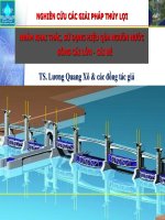
1.5. Research procedure
Study the geographical basis in land use exploition for sustainable planning in
Da Lat city and its vicinities - Lam Dong province
Define goals and missions
Characteristics of arising
geographical conditions degeneration of soil and land
resources in the research area
Determine theoretical basis and
research methods
Integrated land evaluation for sustainable land use
Land ecaluarion and classification
suitable for agriculture and forestry
production
Assess general soil degradation and
determine the degree of degradation
on land units
Geographic zoning for the research area
Proposing orientations for organizing space for sustainable land use
Figure 1.5 Diagram of research steps
11
Chapter 2. CHARACTERISTICS OF ARISING GEOGRAPHICAL
CONDITIONS - DEGENERATION OF SOIL AND LAND
RESOURCES IN DA LAT CITY AND ITS VICINITIES;
2.1. Arising conditions - soil degradation
2.1.1. Geographical location
The research area is located in the north of Lam Dong province,
including the administrative boundaries of Da Lat city and 4 adjacent
districts: Lac Duong, Don Duong, Duc Trong and Lam Ha (referred to as
Da Lat and its vicinities). The region has an average altitude above 850m
above sea level, with geographical coordinates extending from 11030'27” to
12019'4” North latitude and from 108020'18” to 108043'39” East longitude.
The total natural area is 415,101.9 ha, accounting for 42.4% of the
province's total natural area.
2.1.2. Geological and mantle rock characteristics
2.1.2.1. Geological characteristics
The long history of geological development has left the research area
complex geological structure, including ancient sediments, intrusive rocks
or ancient eruptions to basalt eruptions and quaternary and tertiary
sediments which are younger, divided into 5 main rock groups, including:
deposit and metamorphic rocks, granite intrusive rocks, neutral eruptions to
weak acids, basalt eruptions and unconsolidated quaternary sediments.
2.1.2.2. Mantle rock characteristics
In the law of forming Mantle rock (VPH) of the humid monsoon
tropics, the feralitization process (iron and aluminum accumulation) with
laterite and laterite - bauxite formations is a key trend. However, due to the
natural conditions in which the basement rock and topography play the
most important role, the research area has weathered products including:
VPH saprolite, silicite, sialite, sialferite, ferosialite, alferite.
2.1.3. Topographic and geomorphological conditions
The topography of the research area consists of mountainous areas
(medium mountains, high mountains), highlands and plains. The popular
terrain orientation is Northeast - Southwest. The terrain is clearly
hierarchical, lower from the North to the South, including: High level: is
the average high mountain range (1000 - 1500 m), completely up to the
peaks above 2000m (Chu Yang Sin 2,405 m, Lang Biang 2,163 m); Low
level are strong wavy hill-shaped plateaus, consisting of two different
surfaces of about 500m. The above ground surface is 1500m high and the
below surface is 850-1000m high.
2.1.4. Climate and hydrological characteristics
2.1.4.1. Climate characteristics
The study area is characterized by a tropical monsoon tropical climate,
strongly influenced by the monsoon tropical circulation and high belt. The
differentiate of the terrain has divided into climatic regions with different
characteristics, it can be divided into 2 regions: (1) Climate zone of Da Lat
12
plateau: There is a tropical monsoon climate, cool and cold, with an
average temperature of 18.20C, the average rainfall of 1865mm/ year and
the dry season is 3 months long; (2) Climate zone of Lam Ha - Duc Trong Don Duong: There is a warm-to-hot tropical monsoon climate, no cold
season, the average annual temperature of 21.30C, the coldest month’s
temperature is 19.60C, average annual rainfall is 1577.4 mm/year, dry
season for 3-4 months.
2.1.4.2. Hydrological characteristics
a. Surface water: Located in high mountainous terrain with strong rainfall,
the network of rivers and streams in ther research area is quite rich. The
two main rivers are Da Dang and Da Nhim Rivers.
b. Groundwater: Groundwater reserves of the research area are distributed
very unequally between regions and can be divided into the following water
storage units: (1) The gap aquifers; (2)The cracked aquifers.
2.1.5. Characteristics of vegetation
2.1.5.1. Natural forest vegetation: including broad-leaved evergreen
closed forest; mixed broad-leaved and coniferous forests; thin coniferous
forest; bamboo forest; bush and grassland.
2.1.5.2. Artificial vegetation: plantation forest community; industrial
forest community and other perennials; annual tree community.
2.1.6. Human activities in land exploitation and use
The increase in mechanical population in recent years has put pressure
on environmental resources - the need to use land for socio-economic
development is great. Most of the area has been put into use, of which the
group of agricultural land is 384,808.8 ha, accounting for 92.7% of natural
land, including agricultural production land which is 157,058.8 ha,
accounting for 37.8% of natural land and forestry land is 226,451.2 ha,
accounting for 54.6% of the natural area; Non-agricultural land is 24,843.0
ha, accounting for 6.0% of natural area. There is also unused land which is
5,450.1 ha, accounting for 1.3% of natural area.
In the agricultural land group of the region, there are 7 main types of
land use for agro-forestry production, including: Types of annual land use
(rice, crops (vegetables, flowers)); Types of perennial tree land use
(coffee, tea, mulberry, fruit trees); Types of land use for forestry
production (three-leaf pine).
2.2. Characteristics of land resources in Da Lat city and its vicinities
2.2.1. Processes of land generation: The process of washing and
accumulating clay, the process of destroying clay minerals and
accumulating aluminum iron, the process of accumulating humus and
forming humus soil in mountains, the process of gleying.
2.2.2. Classification system and characteristics of major soil groups
Land resources in the studied area are divided into 16 land units under
8 soil groups. In particular, the zonal soil group has absolute dominance
with 86.2% of the natural area, including the red-yellow soil group
13
(accounting for 85.0% of the natural area), the groups of black soil, gray
soil, soil exposing gravel and rock with negligible area; The azonal soil
group in high rims of mountains with an area accounting for 6.3% of the
natural area, including the group of red-yellow humus soil in mountains
(6.1% of the natural area) and the group of humus soils in high mountains
with very small area; The inland zonal soil group on the river alluvium
accounts for 6.4% of the natural area, including the valley soil on sloping
products (accounting for 3.7% of the natural area) and the alluvial soil
group (accounting for 2.7% of the natural area).
2.2.3. Actual soil fertility
The map of actual soil fertility reflects the soil fertility at the time of
the study. On the basis of analyzing and combining component maps
according to the norms with clear differentiation among soil types
including: pHKCl, OM, Nts, P2O5dt, K2Odt, CEC by the method of scoring and
calculating the average, it has divided the actual fertility of the studied area
into 3 levels as follows: The land area with high fertility occupies a large
proportion in the studied area, reaching 61.8% of the natural area; The land
area with average fertility reaches 31.8% of the natural area; The land area
with low fertility reaches 5.2% of the natural area.
Chapter 3. EVALUATION, CLASSIFICATION OF LAND AND
GENERAL SOIL DEGRADATIONIN DA LAT CITY AND ITS
VICINITIES
3.1. Evaluation and classification of land for agricultural and forestry
production in Da Lat city and its vicinities
3.1.1. Selection for promising types of land use
Based on the results on surveying the current state of land use and
evaluating economic efficiency of major types using agricultural - forestry
production land in the studied area. The types that use dominant land in area
and socio-economic efficiency have been selected for the evaluatin,
including: wet rice, cash crops (vegetables and flowers), Robusta coffee,
Arabica coffee, tea, mulberry trees, fruit trees, three-leave pines.
3.1.2. Establishing Land unit mapping
3.1.2.1. Selecting and decentralizing norms
Based on the study of ecological requirements of evaluated land use
types and actual land properties (including: soil, topography, climate,
hydrology, irrigation) of the studied area, 12 norms have been selected to
build land unit mapping, scale of 1/50,000: soil type, thickness of soil
layers, mechanical composition, actual soil fertility, elevation, slope,
average annual rainfall, average annual temperature, average rainfall of
two months after harvest (January, February), distribution of drought
areas, irrigation conditions.
3.1.2.2. Land unit mapping
Land unit mapping of Da Lat city and its vicinities is built by
overlaying thematic maps of 12 selected norms. Each land mapping unit
14
contains all the information presented in thematic maps and is distinguished
from other units by the difference of at least one element. The aggregate
results have identified 1,129 land mapping units (LMU), which are
decentralized according to the area scale in Table 3.2.
Table 3.2. Summary of land mapping units according to the area scale
No.
1
2
3
4
5
Area scale (ha)
<10
10 - 100
100 - 500
500 – 1.000
> 1.000
Total land area
Rivers, streams, lakes
Total natural area
Area (ha)
182.7
1,352.6
181,487.8
100,111.3
126,968.7
410,103.1
4,998.8
415,101.9
LMU quantity
176
39
693
146
75
1,129
Ratio (%)
0.1
0.3
44.3
24.4
31.0
98.8
1.2
100.0
3.1.3. Determining ecological requirements of land use types
Based on natural conditions in the studied area and referring to values
of ecological requirements of tropical and subtropical crops of Sys Ir. C.,
(1993), and inheriting the relevant results of studies, the ecological
requirements of land use types have been determined in 4 levels of
suitability: S1 - very suitable, S2 - suitable , S3 - less suitable and N - not
suitable
3.1.4. Results on evaluating and classifying land for agriculture and
forestry production
The evaluation and classification are done by comparing the
characteristics of land units with ecological requirements of the selected
land use types, according to 2 evaluation methods (limited conditions,
dominant factors) and 4 levels of land suitability (S1, S2, S3, N) of FAO
(section 1.3.2.1), based on the integration of Automated Land Evaluation
Software ALES and geographic information system GIS.
The result is that the land suitablity classification maps for different
types of agricultural and forestry production land use in the studied area are
built at 1/50,000 scale (Table 3.4).
Table 3.4. Area of land suitability level by types of land use
LUTs
1. Rice
2.
Cash
crops
(vegetables,
flowers)
3. Robusta
coffee
4. Arabica
coffee
Area / Ratio
Ha
%
Natural
land area
Ha
%
Natural
land area
Ha
%
Natural
land area
Ha
%
Natural
land area
Levels of suitablity
Very
Less
Suitable
suitable
suitable
(S2)
(S1)
(S3)
5,336.9
16,256.0
7,467.3
Not suitable
(N)
Total
natural
land area
381,042.9
410,103.1
1.3
4.0
1.8
92.9
100.0
8,588.3
71,999.1
14,953.7
314,562.0
410,103.1
2.1
17.2
3.6
77.1
100.0
2,417.8
29,308.9
56,677.1
321,699.3
410,103.1
0.6
7.1
13.8
78.4
100.0
-
52,760.8
111,144.3
246,197.9
410,103.1
-
12.9
27.1
60.0
100.0
15
5. Tea
6. Mulberry
trees
7. Fruit trees
8.
Threeleave pines
Ha
%
Natural
land area
Ha
%
Natural
land area
Ha
%
Natural
land area
Ha
%
Natural
land area
-
44,677.7
130,960.3
234,465.1
-
10.9
31.9
57.2
410,103.1
100.0
14,798.4
30,910.2
25,753.0
338,640.6
410,103.1
3.6
7.5
6.3
82.6
100.0
12,360.1
50,169.6
104,992.8
242,580.6
410,103.1
3.0
12.2
25.6
59.2
100.0
7,330.5
121,898.1
227,290.9
53,583.5
410,103.1
1.8
29.7
55.4
13.1
100.0
3.2. Evaluation on integrated soil degradation in Da Lat city and its
vicinities
3.2.1. Causes and specific soil degradation processes
3.2.1.1. Causes of soil degradation include: (1) Natural causes: The
topography is steep, sharply divided; Concentrated season rain and profound
division of rainy season and dry season; Drought; (2) Activities of exploiting
and using land by human: Deforestation for agricultural land; Unsustainable
cultivation on sloping land; Using chemical fertilizers and pesticides;
Urbanization and infrastructure development; Activities of mining and
mineral processing .
3.1.1.2. Processes of soil degradation include: Erosion, washout; Feralite laterite forming clumps, laterite; Chemical degradation; Gley; landslide;
Soil pollution.
3.2.2. Evaluation on soil degradation
3.2.2.1. Evaluation on potential soil degradation
On such basis, analyzing and evaluating the factors and processes of
soil generation - degradation of the studied area, allowing to select and
decentralize norms for evaluating potential soil degradation, including 7
norms under 4 types as follows: Soil (basement rock/specimen, mantle rock
and thickness of soil layers); Topography (topography morphology and
topography slope); Climate (degree of drought); Potential erosion level.
The combination of component maps corresponding to the evaluation
norms allows the creation of potential soil degradation maps at the scale of
1/50,000 under 3 grades: Light degradation potential (TN1) occupies the
smallest area of 30,579.3 ha, equivalent to 7.4% of total natural area;
Average degradation potential (TN2) occupies an area of 135,007.3 ha,
equivalent to 32.5% of total natural area; Strong degradation potential
(TN3) occupies a very large area with 244,516.5 ha, equivalent to 58.9% of
total natural area.
3.2.2.2. Evaluation on current soil degradation
Based on the characteristics of the studied area, the norms are selected
and decentralized to evaluate the current soil degradation, including: the
humus content (OM%), the current state of indicator vegetation and the
current erosion level.
The combination of component maps corresponding to the evaluation
16
norms allows the creation of the current soil degradation map in the studied
area at the scale of 1/50,000 under 3 grades: none or weak degradation
(HT1) dominates with 250,168.4 ha, equivalent to 60.3% of the natural
area; Average degradation (HT2) with114,133.0 ha, accounting for 27.5%
of the natural area; Strong degradation (HT3) with 45,801.6 ha, accounting
for 11.0% of the natural area
3.2.2.3. Evaluation on general soil degradation
Based on the matrix of combination between potential soil degradation
and current soil degradation, it is allowed to evaluate the level of general
soil degradationin the studied area on a map with scale of 1/50,000 under 3
grades: Slight degradation (TH1) with an area of 92,684.8 ha, accounting
for 22.3% of the natural area; Average degradation (TH2) with the largest
area of 294,168.3 ha, accounting for 70.9% of the natural area; Strong
degradation (TH3) with the smallest area of 23,249.9 ha, accounting for
5.6% of the natural area.
Chapter 4. PROPOSAL OF SPATIAL ORIENTATION AND
SUSTAINABLE LAND USE SOLUTIONS FOR DA LAT CITY AND
ITS VICINITIES
4.1. Soil geographic zoning of Da Lat city and its vincinities
4.1.1. The specificity in the differentiation of soil cover
The differentiation of soil cover by geographical latitude to form soil
geographic zoning units is not clearly shown by the influence of azonal factors,
of which the topography is the dominant factor that makes the differentiation.
However, the general nature of the soil geographic zoning unit system is still
determined by its sub-equatorial tropical monsoon climate factor.
4.1.2. Percentile system and norms of soil geographic zoning
The percentile system used for soil geographic zoning maps of Da Lat
city and its vinicities at a scale of 1/100,000 includes: soil geographic
regional level and sub-regional level. In particular, each level has specific
zoning norms as follows (Table 4.1).
Table 4.1. The soil geographic zoning system
No.
1
2
Percentile level
Region
Sub-region
Zoning norms
The homogeneity of soil complexes differentiated by topography
elevation, bioclimatology and characteristics of basement
rock/speciment on the territory formed soil geographic regions. Of
which, the dominant factordifferentiation is topography.
The homogeneity of soil complexes differentiated according to
topography and land use characteristics of each region separates
into soil geographic sub-regions.
4.1.3. Results of geographic zoning in Da Lat city and its vicinities
On the basis of the percentile system and norms of levels used in soil
geographic zoning in Da Lat city and its vicinities at the scale of 1/100,000.
The soil cover of the studied territory is divided into 5 soil geographic
regions with 19 sub-regions with different characteristics and directions of
land use and protection.
- Region with humus - yellow red feralite soil in medium mountains of Chu
Yang Sin (I), is differentiated into 3 sub-regions, of which the red-yellow
17
feralite sub-region on the acidic magma and sediments of North Lac Duong
(Sub-region 1) with the largest area, accounting for 9.1% of the natural
area.
- Region of feralite - yellow red humus land in the plains and highlands of
Dalat (II), is differentiated into 5 sub-regions, of which sub-region with
yellow red feralite soil on neutral magma to South Dalat acid (Sub-region 8)
with the largest area, accounting for 8.5% of the natural area.
- Region with red yellow feralite soil in low mountains of West Chu Yang
Sin (III), is differentiated into 2 sub-regions, of which sub-region with
yellow red feralite soil on neutral magma to acid and sediments of West
Lam Ha (Sub-region 9) with the largest area, accounting for 3.6% of the
natural area.
- Region with red brown, yellow brown feralite soil in Lam Ha - Duc Trong
basalt plateau (IV), is differentiated into 4 sub-regions, of which the subregion with yellow-brown feralite soil and sloping soil on basalt of South
Lam Ha (Sub-region 13) with the largest area, accounting for 9.7% of the
natural area.
- Region with red yellow feralite soil in low mountains of Don Duong - Duc
Trong (V), is differentiated into 5 sub-regions, of which, the sub-region
with yellow red feralite soil on shale of South Duc Trong (Sub-region 18)
with the largest area, accounting for 8.3% of the natural area.
4.1.4. Summary of evaluation results, land classification and soil
degradation according to soil geographic sub-regions
4.1.4.1. Results of land suitability classification S1, S2 according to soil
geographic ub-regions
Based on the results of evaluating land classification for agriculture
and forestry development in Da Lat city and its vicinities, the thesis has
synthesized the land area with the rating class that is very suitable (S1) and
suitable (S2) for selected land use types: annual crops (rice, cash crops),
perennial crops (Arabica coffee, Robusta coffee, tea, mulberry trees, fruit
trees), artificial forests ( three-leave pines) classified by soil geographic
sub-regions. The results have shown the land potential for agro-forestry
development of soil geographic sub-regions.
4.1.4.2. Results on evaluating general soil degradation according to soil
geographic sub-regions
Based on the results on evaluating general soil degradation in Da Lat
city and its vicinities, the thesis has synthesized the area of soil degradation
levels by soil geographic sub-regions. The results have shows the warning
level of soil degradation in exploitation and use by soil geographic subregions.
4.2. Analysis for development planning and plans related to the
territory of Dalat city and its vicinities
Including: Agriculture and forestry development planning and plans
for the 2016-2025 period and orientation to 2030; Spatial development
planning for Da Lat city until 2030 and vision to 2050.
18
SOIL GEOGRAPHIC ZONING MAP OF DA LAT CITY AND ITS VICINITIES
Prepared by: Postgraduate Nguyen Thi Thuy
4.3. Spatial orientation and sustainable land use solutions for Da Lat
city and its vicinities
4.3.1. Orientation of sustainable land use spaces for Da Lat city and its
vicinities
From the results on evaluating, classifying land and general soil
degradation, combined with the synthesis and analysis of such results with the
current state of land use, characteristics and directions of land use - protection
of soil geographic sub-regions, the development planning and plans of
agriculture and forestry sectors, spatial development planning of Da Lat city
and its vicinities, the thesis proposes spaces of sustainable land use by land unit
of Da Lat city and its vicinities. The results are shown in Table 4.6.
Table 4.6. The result for orientation of sustainable land use spaces by land units
No.
1
1.1
1.1.1
1.1.2
1.1.3
1.2
1.2.1
1.2.2
1.2.3
1.2.4
1.2.5
1.2.6
2
2.1
2.2
Land use types
Land for agriculture production
Annual crop land
Rice land
Land for cash crops
Land for other annual crops
Land for perennial crops
Land for Arabica coffee
Land for Robusta coffee
Land for tea
Land for mulberry trees
Land for fruit trees
Land for other perennial crops
Forestryland
Forest land for three-leave pines
Land piece for regenerating natural
forests
2.3
Forest land with forests and
culturing piece for protecting
natural forests
3
Urban land
3.1
Residential land
3.2
Other non-agricultural land
4
Unused land
5
Other land
Total land area
Rivers, streams
Total natural area
Current state
Diện tích
Tỷ lệ
(ha)
(%)
157,058.7
37.8
44,374.7
10.7
9,144.7
2.2
26,958.1
6.5
8,271.9
2.0
112,684.0
27.1
15,928.0
3.8
88,792.6
21.4
932.4
0.2
1,619.0
0.4
4,650.0
1.1
762.0
0.2
226,451.2
54.6
17,563.4
4.2
Proposal
Diện tích
(ha)
118,573.8
42,219.6
7,939.6
26,278.6
8,001.4
76,354.2
16,931.0
50,086.0
907.1
2,560.1
5,135.4
734.6
270,386.2
52,648.9
Tỷ lệ
(%)
28.6
10.2
1.9
6.3
1.9
18.4
4.1
12.1
0.2
0.6
1.2
0.2
65.1
12.7
Increase/
decrease
(ha)
-38,484.9
-2,155.1
-1,205.1
-679.5
-270.5
-36,329.8
1,003.0
-38,706.6
-25.3
941.1
485.4
-27.4
43,935.0
35,085.5
0
0.0
8,849.5
2.1
8,849.5
208,887.8
50.3
208,887.8
50.3
0
19,844.4
5,521.1
14,323.3
5,450.1
1,298.8
410.103,1
4.998,8
415.101,9
4.8
1.3
3.5
1.3
0.3
98.8
1.2
100.0
19,844.4
5,521.1
14,323.3
0
1,298.8
410.103.1
4.998.8
415.101.9
4.8
1.3
3.5
0.0
0.3
98.8
1.2
100.0
0
0
0
-5,450.1
0
0
0
0
4.3.2. Spatial orientation for developing soil geographic sub-regions of
Da Lat city and its vicinities
Based on the summary of the orientation of sustainable land use spaces
by soil geographic sub-regions, the analysis of characteristics and
directions of land use and protection of soil geographic sub-regions, and at
the same time referring to the spatial development planning of Dalat city
until 2030 and vision to 2050, the thesis proceeds orienting the structure of
land use spaces and development spaces for soil geographic sub-regions as
a basis for sustainable territorial organization of Da Lat city and its
vicinities, the results are shown in Tables 4.8 and 4.9.
19
Table 4.8. Orientation for the structure of sustainable land use spaces by soil
geographic sub-regions
Subregions
Subregion 1
Subregion 2
Subregion 3
Subregion 4
Subregion 5
Subregion 6
Subregion 7
Subregion 8
Subregion 9
Subregion
10
Subregion
11
Subregion
12
Subregion
13
Subregion
14
Subregion
15
Subregion
16
Subregion
17
Subregion
18
Subregion
19
Annual
crops
Perennials
0.2
0.1
Agricultural development: 0.3
0.2
0.2
Agricultural development: 0.4
0.3
0.6
Agricultural development: 1.0
4.7
4.4
Agricultural development: 9.0
10.4
5.6
Agricultural
development:
16.0
19.7
5.3
Agricultural development:
25.0
1.4
20.7
Agricultural development:
22.1
3.9
1.9
Agricultural development: 5.8
5.5
0
Agricultural development: 5.5
7.8
51.5
Agricultural development:
59.4
10.9
52.2
Agricultural development:
63.1
21.9
32.7
Agricultural development:
54.6
12.8
70.1
Agricultural development:
82.9
16.8
53.8
Agricultural development:
70.5
42.8
18.1
Agricultural development:
60.9
3.1
1.3
Agricultural development: 4.4
Forest land
with forests
and
Artificial
culturing
forests
piece for
protecting
natural
forests
1.2
3.0
95.6
Forestry development: 99.8
0.9
2.0
96.7
Forestry development: 99.5
3.4
0.4
89.8
Forestry development: 93.5
8.5
1.1
79.7
Forestry development: 89.2
25.3
3.9
47.4
Forestry development: 76.6
Land piece
for
regenerating
natural
forests
Urban
land
0.1
0.1
0
0.8
3.5
22.9
0.8
31.7
Forestry development: 55.4
18.5
23.6
0.1
50.6
Forestry development: 74.3
3.5
2.2
62.8
Forestry development: 90.8
23.5
2.8
67.4
Forestry development: 93.7
26.6
4.7
6.0
Forestry development: 37.2
2.2
23.4
1.3
6.8
Forestry development: 31.5
5.2
17.9
0.7
2.8
Forestry development: 21.4
21.7
1.8
1.4
4.1
Forestry development: 7.3
7.7
7.4
0.3
10.1
Forestry development: 17.8
5.3
17.4
1.6
9.2
Forestry development: 28.1
10.0
16.7
2.0
76.4
Forestry development: 95.1
0.4
1.7
0.1
Agricultural development: 1.8
7.2
42.0
48.9
Forestry development: 98.1
0.1
11.3
1.6
Agricultural development:
12.9
26.9
28.8
Agricultural development:
55.7
14.1
0.7
67.7
Forestry development: 82.4
2.5
9.1
0.2
23.5
Forestry development: 32.8
6.4
25.8
20
0.1
3.3
Table 4.9. Statistics of development priority spaces of soil geographic sub-regions
Orientation of development spaces
1. Forestry preserving
biodiversity,
protecting
and
supplying water
2. Protection and
production forestry
Priority for preservation and restoration for developing specialuse and protective natural forests
Priority for protection and development of riverhead protective
forests and special-use forests
Priority for protection and development of protective natural
forests and production forests in reservoir basins
Priority for protection and development of protective natural
forests in reservoir basins and planting production forests
Priority for protection of protective forests and development of
production forests
Priority for protection of protective forests and development of
production forests
Priority for development of production forests and restoration of
regenerating natural forests
3. Production forestry
and
agro-forestry
models
Priority for development of natural production forests and
agroforestry models
Priority for protection and development of protective natural
forests, production forests and agroforestry models
Priority for protection and development of protective natural
forests in reservoir basins, agroforestry models
4.
Specialized
agriculture,
agroforestry models and
populations
Priority for development of agriculture specializing in perennial
crops and agroforestry models
Priority for development of agriculture specializing in perennial
crops, agro-forestry models and populations
Priority for development of agriculture specializing in perennial
crops and populations
Priority for development of agriculture specializing in perennial
crops, agro-forestry models and populations
Priority for development of agriculture specializing annual crops,
agro-forestry models and populations
Priority for development of specialized agriculture, agroforestry
model and populations
5. Satellite towns
6. Center towns
Priority for protection of protective natural forests in reservoir
basins and development of satellite towns in combination with
forestry-agriculture models.
Priority for development of satellite towns, specialized agriculture
and agroforestry models
Priority for preservation and development of natural forests and
traditional urban landscapes combied with ecological agriculture
Subregions
Subregion 1
Subregion 2
Subregion 3
Subregion 8
Subregion 9
Subregion
16
Subregion
17
Subregion 4
Subregion 7
Subregion
18
Subregion
10
Subregion
11
Subregion
13
Subregion
14
Subregion
15
Subregion
19
Subregion 5
Subregion
12
Subregion 6
4.3.3. Solutions for sustainable land use in Da Lat city and its vicinities
4.3.1.1. Solutions to prevent, limit and improve generally degraded soil:
Consist of cultivation solutions, construction solutions, biological solutions.
4.3.3.2. Solutions for sustainable land use according to type of land use
Based on the level of general soil degradationaccording to major land
use types and sustainable land use orientations according to land units in
the studied area, solutions for sustainable land use according to land use
types on the general soil degradationunits are proposed.
21
SPATIAL ORIENTATION MAP FOR SUSTAINABLE LAND USE
IN DA LAT CITY AND ITS VICINITIES
Prepared by: Postgraduate Nguyen Thi Thuy